NASA sees wind shear end Tropical Cyclone Amos
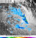
On Sunday, April 24, 2016 Tropical Cyclone Amos ran into increasing wind shear that tore the storm apart. A composite satellite image from two satellites showed waning precipitation and lack of thunderstorm development from wind shear. Visible imagery from NOAA's GOES-West on April 24, 2016 at 0252 UTC (April 23, 2016 at 10:52 p.m. EDT) and precipitation data from NASA and the Japan Aerospace Exploration Agency's Global Precipitation Measurement (GPM) Mission on April 24, 2016 at 0321 UTC (April. 23, 2016 at 11:21 a.m. EDT) was combined at the U.S. Naval Research Laboratory in Washington, D.C. The imagery showed the storm had elongated because of the wind shear. Heaviest rainfall, at about 1 inch (25 mm) per hour appeared in the northwestern quadrant of the storm on GPM radar.
By 1500 UTC (11 a.m. EDT) on April 24, 2016 Amos moved past Pago Pago and continued on an easterly track at 7 knots (8 mph/12.9 kph) while weakening. At that time, Amos' maximum sustained winds were near 40 knots (46 mph/74 kph) and it was weakening quickly.
By the end of the day, Amos had dissipated in the Southern Pacific Ocean.
NASA's Goddard Space Flight Center
Source: NASA/Goddard Space Flight Center
Articles on the same topic
- NASA sees Tropical Cyclone Amos threatening American SamoaFri, 22 Apr 2016, 20:02:56 UTC
- NASA sees Tropical Cyclone Fantala slowingFri, 22 Apr 2016, 15:03:03 UTC
- NASA sees Tropical Cyclone Amos intensifyingThu, 21 Apr 2016, 16:38:16 UTC
- NASA sees changes in Tropical Cyclone FantalaThu, 21 Apr 2016, 14:38:14 UTC
- NASA sees birth of Tropical Cyclone 20P, threatens American SamoaWed, 20 Apr 2016, 16:35:21 UTC
- NASA sees Fantala's eye wide open north of MadagascarWed, 20 Apr 2016, 14:08:01 UTC
- NASA's 3-satellite view of powerful Tropical Cyclone FantalaTue, 19 Apr 2016, 16:03:48 UTC
- NASA examines Category 5 Tropical Cyclone Fantala near MadagascarTue, 19 Apr 2016, 16:03:39 UTC
- NASA eyes major Tropical Cyclone Fantala as it triggers warnings for MauritiusTue, 19 Apr 2016, 16:03:28 UTC
Other sources
- NASA sees wind shear end Tropical Cyclone Amosfrom PhysorgMon, 25 Apr 2016, 15:20:58 UTC
- NASA sees Tropical Cyclone Amos threatening American Samoafrom PhysorgFri, 22 Apr 2016, 22:00:57 UTC
- NASA sees Tropical Cyclone Fantala slowingfrom PhysorgFri, 22 Apr 2016, 16:30:48 UTC
- NASA sees Tropical Cyclone Amos intensifyingfrom PhysorgThu, 21 Apr 2016, 17:00:59 UTC
- NASA sees changes in Tropical Cyclone Fantalafrom PhysorgThu, 21 Apr 2016, 15:00:54 UTC
- NASA sees birth of Tropical Cyclone 20P, threatens American Samoafrom PhysorgWed, 20 Apr 2016, 17:31:14 UTC
- NASA sees Fantala's eye wide open north of Madagascarfrom PhysorgWed, 20 Apr 2016, 15:31:52 UTC
- NASA's 3-satellite view of powerful Tropical Cyclone Fantalafrom PhysorgTue, 19 Apr 2016, 16:00:55 UTC
- NASA examines Category 5 Tropical Cyclone Fantala near Madagascarfrom PhysorgMon, 18 Apr 2016, 15:41:38 UTC
- NASA eyes major Tropical Cyclone Fantala as it triggers warnings for Mauritiusfrom PhysorgSat, 16 Apr 2016, 8:10:45 UTC
