NASA examines Category 5 Tropical Cyclone Fantala near Madagascar
Related images
(click to enlarge)
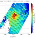
Tropical Cyclone Fantala has become a major tropical cyclone in the Southern Indian Ocean reaching Category 5 status on the Saffir-Simpson Hurricane Wind Scale. NASA's RapidScat instrument observed powerful winds wrapped tightly around the eye, and NASA's Aqua satellite saw the well-structured storm with a wide eye as it was due north of Madagascar early on April 18. On Apr. 17 at 6 a.m. UTC (2 a.m. EDT) the RapidScat instrument that flies aboard the International Space Station (ISS) measured Fantala's surface wind speed and direction over the Southern Indian Ocean. Wind speeds exceeded 30 meters per second (67 mph/108 kph) around the entire center of the storm. Surface wind speed is always lower than speeds at higher altitude. At the time RapidScat passed overhead from the ISS, Fantala was at about its closest point of approach to Madagascar.
RapidScat is an important tool for meteorologists, because it shows forecasters the location of the strongest winds in different quadrants of an area of low pressure or tropical cyclone as they are not always equally distributed.
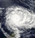
On April 18 at 10:25 UTC (6:25 a.m. EDT) the Moderate Resolution Imaging Spectroradiometer or MODIS instrument aboard NASA's Aqua satellite saw Tropical Cyclone Fantala off Madagascar. The MODIS instrument revealed a 16 nautical-mile-wide eye surrounded by a powerful ring of convective (rising air that forms storms) thunderstorms with a second convective ring beginning to develop. The MODIS image also showed powerful thunderstorms wrapping into the center from the northern and southern quadrants of the storm.
At 0900 UTC (5 a.m. EDT), Tropical Cyclone Fantala was located north of the northern tip of Madagascar, and about 783 nautical miles (901 miles/1,450 km) northwest of Port Louis, Mauritius. Fantala as about 217 miles (350 kilometers) north of Antsiranana. Antsiranana is a city in the far north of Madagascar.
Its eye was centered near 9.3 degrees south latitude and 49.7 degrees east longitude. Fantala's maximum sustained winds were near 150 knots (172 mph/ 277.8 kph). The hurricane-force winds only extended 25 miles (28.7 miles/46.3 km) from the center, making for a very powerful, compact storm. Tropical-storm-force winds extended 100 miles (115 miles/185.2 km) from the center.
Fantala was moving to the west-northwest at 4 knots (4.6 mph/7.4 kph) and generating 40-foot (12.1 meter)-high seas.
The factors steering Fantala are changing, so there's a change in the forecast direction of the storm. The Joint Typhoon Warning Center (JTWC) noted that that the steering mechanism is beginning to shift from the mid-latitude ridge (elongated area of high -pressure) positioned to the south to a building near-equatorial ridge (elongated area of high pressure) to the north of Fantala.
Residents of northern Madagascar should continue to monitor the storm as it is expected approach the island. According to the Joint Typhoon Warning Center forecasters, Fantala will gradually turn on a southeasterly course and begin moving in that direction while slowly weakening. By April 22, the storm is expected to steer toward northeastern Madagascar.
For more information on RapidScat, visit http://winds.jpl.nasa.gov/missions/RapidScat/ and http://www.nasa.gov/rapidscat.
Source: NASA/Goddard Space Flight Center
Articles on the same topic
- NASA sees wind shear end Tropical Cyclone AmosMon, 25 Apr 2016, 15:03:46 UTC
- NASA sees Tropical Cyclone Amos threatening American SamoaFri, 22 Apr 2016, 20:02:56 UTC
- NASA sees Tropical Cyclone Fantala slowingFri, 22 Apr 2016, 15:03:03 UTC
- NASA sees Tropical Cyclone Amos intensifyingThu, 21 Apr 2016, 16:38:16 UTC
- NASA sees changes in Tropical Cyclone FantalaThu, 21 Apr 2016, 14:38:14 UTC
- NASA sees birth of Tropical Cyclone 20P, threatens American SamoaWed, 20 Apr 2016, 16:35:21 UTC
- NASA sees Fantala's eye wide open north of MadagascarWed, 20 Apr 2016, 14:08:01 UTC
- NASA's 3-satellite view of powerful Tropical Cyclone FantalaTue, 19 Apr 2016, 16:03:48 UTC
- NASA eyes major Tropical Cyclone Fantala as it triggers warnings for MauritiusTue, 19 Apr 2016, 16:03:28 UTC
Other sources
- NASA sees wind shear end Tropical Cyclone Amosfrom PhysorgMon, 25 Apr 2016, 15:20:58 UTC
- NASA sees Tropical Cyclone Amos threatening American Samoafrom PhysorgFri, 22 Apr 2016, 22:00:57 UTC
- NASA sees Tropical Cyclone Fantala slowingfrom PhysorgFri, 22 Apr 2016, 16:30:48 UTC
- NASA sees Tropical Cyclone Amos intensifyingfrom PhysorgThu, 21 Apr 2016, 17:00:59 UTC
- NASA sees changes in Tropical Cyclone Fantalafrom PhysorgThu, 21 Apr 2016, 15:00:54 UTC
- NASA sees birth of Tropical Cyclone 20P, threatens American Samoafrom PhysorgWed, 20 Apr 2016, 17:31:14 UTC
- NASA sees Fantala's eye wide open north of Madagascarfrom PhysorgWed, 20 Apr 2016, 15:31:52 UTC
- NASA's 3-satellite view of powerful Tropical Cyclone Fantalafrom PhysorgTue, 19 Apr 2016, 16:00:55 UTC
- NASA examines Category 5 Tropical Cyclone Fantala near Madagascarfrom PhysorgMon, 18 Apr 2016, 15:41:38 UTC
- NASA eyes major Tropical Cyclone Fantala as it triggers warnings for Mauritiusfrom PhysorgSat, 16 Apr 2016, 8:10:45 UTC

