NASA eyes major Tropical Cyclone Fantala as it triggers warnings for Mauritius
Related images
(click to enlarge)
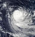
NASA's Aqua satellite spotted an eye in strengthening Tropical Cyclone Fantala while the Global Precipitation Measurement or GPM mission satellite saw heavy rainfall within the powerful hurricane. On Friday, April 15, 2016 as Fantala became a major hurricane, regional warnings were in effect for the Republic of Mauritius. A strong wind warning is in force for Rodrigues, Mauritius, St Brandon and Agalega in the Southern Indian Ocean.
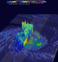
Tropical cyclone Fantala has continued to intensify while moving westward over the open waters of the South Indian Ocean. The GPM core observatory satellite passed directly over Fantala's eye on April 14, 2016 at 0148 UTC (April 13, 2016 at 9:48 a.m. EDT). At that time the tropical cyclone had maximum sustained winds estimated at 90 knots (104 mph) making in the equivalent of a category two tropical cyclone on the Saffir-Simpson hurricane wind scale. GPM's Microwave Imager (GMI) and Dual-Frequency Precipitation Radar (DPR) instruments again captured data that were used to estimate rainfall within Fantala. Rain was measured by GPM's DPR falling at a rate of almost 300 mm (11.8 inches) per hour on the southwestern side of the tropical cyclone's well defined eye. GPM also found some extremely intense showers in a feeder band wrapping around Fantala's northern side where echoes of over 58 dBZ were being returned to the satellite.
At NASA's Goddard Space Flight Center in Greenbelt, Maryland, GPM's radar (DPR Ku Band) were used to create a 3-D structure of precipitation within tropical cyclone Fantala. This image showed a 3-D vertical slice through the center of the tropical cyclone's eye. DPR measured storm top heights above Fantala's eye reaching altitudes above 13 km (8 miles). Extremely tall thunderstorms reaching heights of over 17 km (10.5 miles) were found by GPM in the feeder band on Fantala's northern side. GPM is a joint missions between NASA and the Japanese space agency JAXA.
At 0900 UTC (5 a.m. EDT) on Friday, April 15, 2016, Fantala's maximum sustained winds were near 100 knots (132.3 mph/213 kph) and still increasing. Fantala was a Category 4 hurricane on the Saffir-Simpson Wind Scale, making it a major hurricane.
Fantala was centered near 12.3 degrees south latitude and 59.7 degrees east longitude, about 488 nautical miles north-northeast of Port Louis, Mauritius. Fantala was moving to the west at 10 knots and generating 30-foot high waves.
On April 15 at 09:50 UTC (5:50 a.m. EDT) the Moderate Resolution Imaging Spectroradiometer or MODIS instrument aboard NASA's Aqua satellite captured a visible image of Tropical Cyclone Fantala showing a 10 nautical-mile-wide eye surrounded by a thick band of powerful thunderstorms. The strongest thunderstorms appear to be in the southern quadrant of the storm.
Tropical cyclone Fantala is still increasing in power. The Joint Typhoon Warning Center (JTWC) expects winds to peak at 115 knots on April 17, 2016. The storm will then curve away from Mauritius and head toward the southeast where it will slowly weaken.
Source: NASA/Goddard Space Flight Center
Articles on the same topic
- NASA sees wind shear end Tropical Cyclone AmosMon, 25 Apr 2016, 15:03:46 UTC
- NASA sees Tropical Cyclone Amos threatening American SamoaFri, 22 Apr 2016, 20:02:56 UTC
- NASA sees Tropical Cyclone Fantala slowingFri, 22 Apr 2016, 15:03:03 UTC
- NASA sees Tropical Cyclone Amos intensifyingThu, 21 Apr 2016, 16:38:16 UTC
- NASA sees changes in Tropical Cyclone FantalaThu, 21 Apr 2016, 14:38:14 UTC
- NASA sees birth of Tropical Cyclone 20P, threatens American SamoaWed, 20 Apr 2016, 16:35:21 UTC
- NASA sees Fantala's eye wide open north of MadagascarWed, 20 Apr 2016, 14:08:01 UTC
- NASA's 3-satellite view of powerful Tropical Cyclone FantalaTue, 19 Apr 2016, 16:03:48 UTC
- NASA examines Category 5 Tropical Cyclone Fantala near MadagascarTue, 19 Apr 2016, 16:03:39 UTC
Other sources
- NASA sees wind shear end Tropical Cyclone Amosfrom PhysorgMon, 25 Apr 2016, 15:20:58 UTC
- NASA sees Tropical Cyclone Amos threatening American Samoafrom PhysorgFri, 22 Apr 2016, 22:00:57 UTC
- NASA sees Tropical Cyclone Fantala slowingfrom PhysorgFri, 22 Apr 2016, 16:30:48 UTC
- NASA sees Tropical Cyclone Amos intensifyingfrom PhysorgThu, 21 Apr 2016, 17:00:59 UTC
- NASA sees changes in Tropical Cyclone Fantalafrom PhysorgThu, 21 Apr 2016, 15:00:54 UTC
- NASA sees birth of Tropical Cyclone 20P, threatens American Samoafrom PhysorgWed, 20 Apr 2016, 17:31:14 UTC
- NASA sees Fantala's eye wide open north of Madagascarfrom PhysorgWed, 20 Apr 2016, 15:31:52 UTC
- NASA's 3-satellite view of powerful Tropical Cyclone Fantalafrom PhysorgTue, 19 Apr 2016, 16:00:55 UTC
- NASA examines Category 5 Tropical Cyclone Fantala near Madagascarfrom PhysorgMon, 18 Apr 2016, 15:41:38 UTC
- NASA eyes major Tropical Cyclone Fantala as it triggers warnings for Mauritiusfrom PhysorgSat, 16 Apr 2016, 8:10:45 UTC

