NASA sees dawn and records breaking as major winter storm departs
Related images
(click to enlarge)
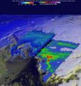
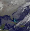
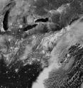
NASA and NOAA gathered night-time and daytime views of the Blizzard of 2016 from the Suomi NPP and the GOES-East satellites. NASA's GPM satellite provided a look at the moisture wrapping into the storm from the Atlantic Ocean. The 2016 blizzard occurred just 4 days before 2015's major northeast blizzard. GPM's 3-D View of Storm's Moisture From the Atlantic Ocean
On Jan. 23, 2016 at 1239 UTC (7:39 a.m. EST) NASA and the Japan Aerospace Exploration Agency's Global Precipitation Measurement (GPM) core observatory passed above the deadly winter storm that was burying the Northeast under a deep layer of snow. As GPM passed above, it observed a band of snow approaching the island of Manhattan. GPM's Microwave Imager (GMI) and Dual-frequency Precipitation Radar (DPR) instruments showed massive amounts of moisture being transported from the Atlantic Ocean over states from New York westward through West Virginia. GPM's Radar instruments provided 3-D data (DPR Ku Band) showing the 3-D structure of rainfall within bands of precipitation in the winter storm.
A Night-time View by Satellite
A combination of the day-night band and high resolution infrared imagery from the NASA-NOAA's Suomi NPP satellite showed the historic blizzard as it moved north of the Mid-Atlantic and over the New York Metropolitan area and southern New England at 06:55 UTC (1:55 a.m. EST) on January 24, 2016. The nighttime lights of the region were blurred by the high cloud tops associated with the storm.
On Sunday, Jan. 24, 2016 at 3:55 a.m. EST NOAA's National Weather Service Weather Prediction Center in College Park, Maryland said "Snow is tapering off over the Mid-Atlantic and Northeast as the winter storm system tracks further offshore. This system dumped copious amounts of snow over West Virginia, Virginia, Washington D.C., Maryland, Pennsylvania, New Jersey and New York. A few locations came close to, or surpassed all-time 1-day and 2-day snow records. Accumulations of 2 to 3 feet were common, with a few isolated areas in the West Virginia and Maryland panhandles measuring 3.5 feet."
Snowfall Records Broken in Mid-Atlantic
This storm set quite a number of snowfall records in the Mid-Atlantic north to New York City on Jan. 23, 2016. In the Baltimore/Washington metro area, all three airports recorded record snowfall according to NOAA's National Weather Service.
A record snowfall of 11.3 inches was set at Washington Reagan National airport. This breaks the old record of 11.0 set in 1935. A record snowfall of 25.5 inches was set at Baltimore BWI Thurgood Marshall airport. This breaks the old record of 11.5 set in 1935. A record snowfall for the day of 22.1 inches was set at Washington Dulles airport yesterday. This breaks the old record of 1.7 set in 1982.
Snowfall records also fell from Richmond, Virginia to Harrisburg, Pennsylvania. The NWS noted that a record snowfall of 5.3 inches was set at Richmond, Virginia. This breaks the old record of 2.7 inches set back in 1908. In central Pennsylvania, snow totals were much higher. A record daily snowfall of 26.4 inches was set at Harrisburg. This breaks the old record of 9.5 inches set on January 23 in 1982. A continuous weather record has been kept at Harrisburg since 1888.
Snowfall Records Fall in the Northeast
Newark, New Jersey, Central Park in New York City and Connecticut also reported record-breaking snowfall on Jan. 23. 2016.
A record snowfall of 27.5 inches was set at Newark, New Jersey. This breaks the old record of 4.5 set in 2005.
According to the National Weather Service, Central Park received the second greatest storm total snowfall set and the greatest daily snowfall record. Storm total snowfall for the current snowstorm at midnight was at 26.8 inches. This is only 0.1 inch shy of the all-time record storm total snowfall of 26.9 inches...set during the snowstorm of Feb. 11-12 2006. A record all time daily snowfall record snowfall of 26.6 has also been set at the park. The previous record was 24.1 inches...set on Feb. 12, 2006.
To the northeast in Connecticut, a record snowfall of 12 inches was set at Bridgeport. This breaks the old record of 7.1 set in 1965.
In Westerly, Rhode Island, 10.5 inches of snow were reported and East Harwich, Massachusetts on Cape Cod reported 15.5 inches.
A Daytime Satellite View on Jan. 24, 2016
As residents from the Mid-Atlantic to the northeastern U.S. were waking up to daylight and the record-setting snowfall at 11:45 UTC (6:45 a.m. EST) on Jan. 24, 2016, NOAA's Geostationary Operational Environmental or GOES-East satellite showed the system centered over the North Atlantic Ocean just east of Cape Cod, Massachusetts.
The image was created by the NASA/NOAA GOES Project at NASA's Goddard Space Flight Center in Greenbelt, Maryland.
GOES satellites provide the kind of continuous monitoring necessary for intensive data analysis. Geostationary describes an orbit in which a satellite is always in the same position with respect to the rotating Earth. This allows GOES to hover continuously over one position on Earth's surface, appearing stationary. As a result, GOES provide a constant vigil for the atmospheric "triggers" for severe weather conditions such as tornadoes, flash floods, hail storms and hurricanes.
One Year Ago: An Historic Northeastern U.S. Blizzard/p>
Back in 2015, NASA and NOAA satellites were covering another blizzard that happened within the same week. On Jan. 27, 2015 the National Weather Service noted "the powerful nor'easter that brought moderate to heavy snowfall and blizzard conditions to the Northeast on Monday will continue to affect the region on Tuesday, with heavy snow and blizzard conditions expected from eastern Long Island to Maine as the system slowly moves to the northeast."
Over the last two years, the last week of January has brought two record-setting storms and NASA and NOAA satellites continue to provide valuable data to forecasters.
For updated information about the storm system, visit NOAA's NWS website: http://www.weather.gov
For more information about GOES satellites, visit: http://www.goes.noaa.gov/ or goes.gsfc.nasa.gov/
For more information about Suomi NPP, visit: http://www.jpss.noaa.gov and http://npp.gsfc.nasa.gov/
For information about the January 2015 storm, visit: http://www.nasa.gov/content/goddard/nasa-and-noaas-nighttime-and-daytime-views-of-the-blizzard-of-2015
Source: NASA/Goddard Space Flight Center
Articles on the same topic
- NASA provides a look at post-blizzard snowfall and windsMon, 25 Jan 2016, 23:21:55 UTC
- NASA sees winter storm slamming eastern United StatesMon, 25 Jan 2016, 16:43:39 UTC
- NASA eyes powerful winter storm spreading into mid-AtlanticFri, 22 Jan 2016, 22:15:06 UTC
- NASA sees gulf coast severe weather from developing winter stormFri, 22 Jan 2016, 16:26:41 UTC
Other sources
- NASA Provides a Look at Post-Blizzard Snowfall and Windsfrom Newswise - ScinewsWed, 27 Jan 2016, 19:41:05 UTC
- NASA provides a look at post-blizzard snowfall and windsfrom PhysorgTue, 26 Jan 2016, 8:40:39 UTC
- NASA sees dawn and records breaking as major winter storm departsfrom PhysorgMon, 25 Jan 2016, 17:03:45 UTC
- NASA sees winter storm slamming eastern United Statesfrom PhysorgMon, 25 Jan 2016, 16:14:11 UTC
- Winter Storm Views from Space: See the Latest Satellite Imagesfrom Live ScienceSat, 23 Jan 2016, 0:21:02 UTC
- NASA eyes powerful winter storm spreading into mid-Atlanticfrom PhysorgFri, 22 Jan 2016, 23:43:35 UTC
- Winter Storm Views from Space: See the Latest Satellite Imagesfrom Space.comFri, 22 Jan 2016, 22:02:15 UTC
- NASA sees gulf coast severe weather from developing winter stormfrom PhysorgFri, 22 Jan 2016, 16:20:01 UTC
- East Coast energy under threat from winter stormfrom UPIFri, 22 Jan 2016, 14:51:01 UTC
- NASA image: Major winter storm headed for eastern U.S.from PhysorgFri, 22 Jan 2016, 11:00:39 UTC
- NASA Sees Massive Winter Storm Moving Eastfrom Space.comThu, 21 Jan 2016, 23:50:37 UTC
- NASA satellites film major snowstorm approaching East Coastfrom UPIThu, 21 Jan 2016, 20:04:09 UTC
- NASA Sees Massive Winter Storm Moving Eastfrom Live ScienceThu, 21 Jan 2016, 19:36:00 UTC
- SnOMG! Developing Blizzard Seen From Space | Time-Lapse Videofrom Space.comThu, 21 Jan 2016, 16:51:32 UTC
- SnOMG! Developing Blizzard Seen From Space | Time-Lapse Videofrom Live ScienceThu, 21 Jan 2016, 16:38:20 UTC


