NASA catches system 92W become fifth NW Pacific tropical depression
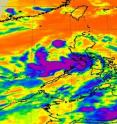
The low pressure system that has been bringing rainfall to the northwestern Philippines has strengthened into the fifth tropical depression of the Northwest Pacific Ocean's hurricane season. Tropical Depression 05W (TD05W) also known as Dodong in the Philippines was caught by infrared NASA satellite imagery on June 8 at 1741 UTC (1:41 p.m. EDT). The infrared data showed some powerful thunderstorms with very cold cloud top temperatures near the threshold of AIRS data of -63 Fahrenheit and -52 Celsius. That indicates the coldest, strongest thunderstorms within the tropical depression. Some of the strongest thunderstorms at that time were over western Luzon and stretched out over the South China Sea.
AIRS microwave imagery today showed that the banding of thunderstorms around the southern edge of the depression had the strongest storms. The storm's convection has decreased today. The decrease in convection is because of an upper-level trough (elongated area) of low pressure to the north that is preventing convection from occurring on the storm's northern side.
At 1500 UTC on June 9, TD05W was about 190 miles northwest of Manila, Philippines near 16.7 North and 118.4 East. It was moving to the north-northwest near 12 knots and had maximum sustained winds near 25 knots with higher gusts. It is now moving toward southern China and is expected to intensify into a tropical storm.
Warnings remain posted in the Philippines as TD05W continues pulling away.
Source: NASA/Goddard Space Flight Center
Articles on the same topic
- NASA's infrared image of major Hurricane Adrian reveals its stormy life's blood13 years ago
- A double-satellite NASA-style view of the first tropical storm in eastern Pacific: Adrian13 years ago
- NASA sees a hot tower in first tropical depression of the eastern Pacific13 years ago
- Possible first eastern Pacific tropical depression shaping up on NASA imagery13 years ago
Other sources
- NASA sees heavy rainfall in Tropical Storm Sarikafrom Physorg13 years ago
- NASA's infrared image of major Hurricane Adrian reveals its stormy life's bloodfrom Physorg13 years ago
- NASA catches system 92W become fifth NW Pacific tropical depressionfrom Physorg13 years ago
- A double-satellite NASA-style view of the first tropical storm in eastern Pacific: Adrianfrom Physorg13 years ago
- Season's first tropical depression formsfrom UPI13 years ago
- Season's first tropical depression formsfrom UPI13 years ago
- NASA sees a hot tower in first tropical depression of the eastern Pacificfrom Physorg13 years ago
- First Hurricane Of Season Forms In Pacificfrom CBSNews - Science13 years ago
- Satellite spots potential Pacific stormfrom UPI13 years ago
- Satellite spots potential Pacific stormfrom UPI13 years ago
- Possible first eastern Pacific tropical depression shaping up on NASA imageryfrom Physorg13 years ago


