Possible first eastern Pacific tropical depression shaping up on NASA imagery
NASA's Aqua satellite flew over a low pressure system in the Eastern Pacific and captured infrared imagery that show it to be well-defined and organizing. System 91E is shaping up to likely become the Eastern Pacific's first tropical depression of the season. Located about 425 miles south of Acapulco, Mexico, System 91E is in a good spot for development: warm sea surface temperatures and low wind shear. Those are two factors needed to help a tropical cyclone develop.
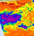
Infrared imagery on June 5 at 19:47 UTC (3:47 p.m. EDT/12:47 PDT) from the AIRS instrument that flies aboard NASA's Aqua satellite showed a large area of strong convection and thunderstorms around the low-level circulation center ofSystem 91E.
The National Hurricane Center gives this low a 90 percent chance of development over the next two days, and if it becomes a tropical storm it would get the name Adrian.
Source: NASA/Goddard Space Flight Center
Articles on the same topic
- NASA sees heavy rainfall in Tropical Storm SarikaFri, 10 Jun 2011, 19:35:45 UTC
- NASA catches system 92W become fifth NW Pacific tropical depressionThu, 9 Jun 2011, 20:37:02 UTC
- NASA's infrared image of major Hurricane Adrian reveals its stormy life's bloodThu, 9 Jun 2011, 20:36:48 UTC
- A double-satellite NASA-style view of the first tropical storm in eastern Pacific: AdrianWed, 8 Jun 2011, 21:02:46 UTC
- NASA sees a hot tower in first tropical depression of the eastern PacificTue, 7 Jun 2011, 21:02:49 UTC
Other sources
- NASA sees heavy rainfall in Tropical Storm Sarikafrom PhysorgFri, 10 Jun 2011, 19:00:28 UTC
- NASA's infrared image of major Hurricane Adrian reveals its stormy life's bloodfrom PhysorgThu, 9 Jun 2011, 21:00:46 UTC
- NASA catches system 92W become fifth NW Pacific tropical depressionfrom PhysorgThu, 9 Jun 2011, 20:31:14 UTC
- A double-satellite NASA-style view of the first tropical storm in eastern Pacific: Adrianfrom PhysorgWed, 8 Jun 2011, 22:00:25 UTC
- Season's first tropical depression formsfrom UPIWed, 8 Jun 2011, 3:30:35 UTC
- Season's first tropical depression formsfrom UPIWed, 8 Jun 2011, 0:00:20 UTC
- NASA sees a hot tower in first tropical depression of the eastern Pacificfrom PhysorgTue, 7 Jun 2011, 21:30:55 UTC
- First Hurricane Of Season Forms In Pacificfrom CBSNews - ScienceTue, 7 Jun 2011, 20:31:29 UTC
- Satellite spots potential Pacific stormfrom UPITue, 7 Jun 2011, 18:30:31 UTC
- Satellite spots potential Pacific stormfrom UPIMon, 6 Jun 2011, 22:00:12 UTC
- Possible first eastern Pacific tropical depression shaping up on NASA imageryfrom PhysorgMon, 6 Jun 2011, 21:30:35 UTC
