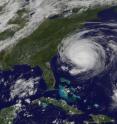
Bermuda in warnings as the GOES-13 Satellite catches Fiona approaching
Bermuda has warnings up as Tropical Storm Fiona approaches, and GOES-13 satellite imagery from today shows that Fiona, although packing a punch, is a much smaller system that her brother, the Category 4 Hurricane Earl. A tropical storm warning is in effect for Bermuda today, Sept. 2, as tropical storm force winds are expected there by late Friday. Bermuda can expect between 1 to 3 inches of rainfall from Fiona.
When the Geostationary Operational Environmental Satellite called GOES-13 captured a visible image of Tropical Storm Fiona approaching Bermuda this afternoon at 1825 UTC (2:25 p.m. EDT) it was a stark contrast in the size of two storms. The huge Category 4 Hurricane Earl nearing North Carolina's coast and is about 400 miles from end to end. Fiona appeared much smaller. Fiona's tropical storm force winds extend 115 miles from the center, although mainly to the east. If those winds were around the circumference of the storm, Fiona would be about 230 miles from end to end, but she's not even that large because most of the strong winds are on one side of the storm. By comparison, Earl dwarfs his "sister."
GOES satellites are operated by NOAA, and the NASA GOES Project at NASA's Goddard Space Flight Center in Greenbelt, Md. produces satellite images and animations from them.
At 2 p.m. EDT on Sept. 2, Tropical Storm Fiona had maximum sustained winds near 50 mph, and slow weakening is forecast in the next 2 days. Fiona was about 520 miles south-southwest of Bermuda near 25.0 North and 66.3 West. She was moving north-northwest near 17 mph, with a minimum central pressure of 1002 millibars.
Source: NASA/Goddard Space Flight Center
Articles on the same topic
- NASA imagery reveals a weaker, stretched out FionaFri, 3 Sep 2010, 18:22:40 UTC
- Infrared NASA image shows strong convection in new Atlantic Depression 9Wed, 1 Sep 2010, 19:08:44 UTC
- NASA infrared data sees convection building in Fiona's cloudsWed, 1 Sep 2010, 18:43:07 UTC
- NASA's Terra Satellite captures 3 tropical cyclones in the northwestern Pacific OceanTue, 31 Aug 2010, 19:43:15 UTC
- GOES-13 catches 3 tropical cyclones thrashing through the AtlanticTue, 31 Aug 2010, 19:43:13 UTC
Other sources
- NASA imagery reveals a weaker, stretched out Fionafrom PhysorgFri, 3 Sep 2010, 18:49:10 UTC
- NASA imagery reveals a weaker, stretched out Fionafrom Science BlogFri, 3 Sep 2010, 18:42:11 UTC
- Bermuda in warnings as the GOES-13 Satellite catches Fiona approachingfrom PhysorgThu, 2 Sep 2010, 21:22:00 UTC
- Bermuda in warnings as the GOES-13 Satellite catches Fiona approachingfrom Science BlogThu, 2 Sep 2010, 21:21:14 UTC
- NASA infrared data sees convection building in Fiona's cloudsfrom PhysorgWed, 1 Sep 2010, 20:56:26 UTC
- NASA spots ninth system of busy storm yearfrom UPIWed, 1 Sep 2010, 20:14:32 UTC
- Infrared NASA image shows strong convection in new Atlantic Depression 9from PhysorgWed, 1 Sep 2010, 20:14:22 UTC
- Infrared NASA image shows strong convection in new Atlantic Depression 9from Science BlogWed, 1 Sep 2010, 19:49:10 UTC
- NASA infrared data sees convection building in Fiona’s cloudsfrom Science BlogWed, 1 Sep 2010, 18:42:11 UTC
- GOES-13 catches 3 tropical cyclones thrashing through the Atlanticfrom PhysorgTue, 31 Aug 2010, 20:28:30 UTC
- GOES-13 catches 3 tropical cyclones thrashing through the Atlanticfrom Science BlogTue, 31 Aug 2010, 20:15:32 UTC
- GOES-13 catches 3 tropical cyclones thrashing through the Atlanticfrom Science BlogTue, 31 Aug 2010, 20:15:20 UTC
- NASA’s Terra Satellite captures 3 tropical cyclones in the northwestern Pacific Oceanfrom Science BlogTue, 31 Aug 2010, 20:15:01 UTC
- NASA's Terra Satellite captures 3 tropical cyclones in the northwestern Pacific Oceanfrom PhysorgTue, 31 Aug 2010, 19:42:23 UTC
