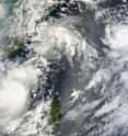
NASA's Terra Satellite captures 3 tropical cyclones in the northwestern Pacific Ocean
NASA's Terra satellite flew over the Northwestern Pacific Ocean at 10:30 p.m. EDT Aug. 30 and captured Tropical Storm Lionrock, Tropical Storm Namtheun, and Typhoon Kompasu in one incredible image. Two of these tropical cyclones are expected to merge, while the other is headed for a landfall in China. On August 31, at 0900 UTC (5 a.m. EDT), Typhoon Kompasu had maximum sustained winds near 109 mph and is 45 nm east-southeast of Kadena AB, Japan. The cyclone will track over Okinawa within the next few hours and continue on a northwestward track for the next 12 to 24 hours, then cross the Korean Peninsula (from western to eastern Korea) into the Sea of Japan, cross northern Japan and exit into the Northwestern Pacific Ocean by September 4.
When the Moderate Resolution Imaging Spectroradiometer (MODIS) instrument that flies on Terra captured the image of all three storms the center of circulation was apparent in Tropical Storm Namtheun, and the eye was visible in Typhoon Kompasu, although some high clouds were filling in the center.
At 1 a.m. EDT, Kadena Air Base wasn't reporting tropical storm force winds from Typhoon Kompasu yet. Kadena Air Base is a United States Air Force base located in the towns of Kadena and Chatan and the city of Okinawa, in Okinawa Prefecture, Japan. Kadena Air Base is the hub of U.S. airpower in the Pacific, and home to the USAF's 18th Wing and a variety of associate units. Kadena Air Base did report, however, that sea level pressure dropped and amazing 44 millibars in less than 2 hours, indicating the Typhoon was approaching.
After impacting Kadena Air Base, Typhoon Kompasu is expected to turn north, then northeast and track over the Korean Peninsula and into the Sea of Japan
The other two tropical cyclones, Tropical Storm Lionrock and Tropical Storm Namtheun, are forecast to merge in the next day or two. NASA satellite data show that the two storms are in close proximity of each other. On August 31 at 0900 UTC (5 a.m. EDT), Tropical Storm Lionrock, formerly Tropical Depression 07W, had maximum sustained winds near 57 mph. It was located about 195 nm southwest of Kaohsiung, Taiwan and it is forecast to merge with Tropical Storm Namtheun (formerly Tropical Depression 09W). Lionrock has moved east-northeastward at 2 mph. Infrared satellite imagery, such as that from the Atmospheric Infrared Sounder (AIRS) instrument that flies aboard NASA's Aqua satellite was showing a decrease in convection in the storm's center. By mid-day (Eastern Time) on Thursday, Lionrock should make the merge with Namtheun and turn northwestward. It is expected to make landfall in eastern China late on Thursday, September 2 and dissipate.
On August 31 at 0900 UTC (5 a.m. EDT) Namtheun was about 80 nautical miles west of Taipei, Taiwan and moving west-southwestward at 8 mph. Its winds were sustained near 39 mph, so it was just at the threshold for being a tropical storm. The storm's low level center is partially exposed because of an upper level trough (elongated area of low pressure) to its north causing wind shear. Despite this, Namtheun is expected to remain the dominant circulation when it merges with Lionrock.
Source: NASA/Goddard Space Flight Center
Articles on the same topic
- NASA imagery reveals a weaker, stretched out FionaFri, 3 Sep 2010, 18:22:40 UTC
- Bermuda in warnings as the GOES-13 Satellite catches Fiona approachingThu, 2 Sep 2010, 20:38:17 UTC
- Infrared NASA image shows strong convection in new Atlantic Depression 9Wed, 1 Sep 2010, 19:08:44 UTC
- NASA infrared data sees convection building in Fiona's cloudsWed, 1 Sep 2010, 18:43:07 UTC
- GOES-13 catches 3 tropical cyclones thrashing through the AtlanticTue, 31 Aug 2010, 19:43:13 UTC
Other sources
- NASA imagery reveals a weaker, stretched out Fionafrom PhysorgFri, 3 Sep 2010, 18:49:10 UTC
- NASA imagery reveals a weaker, stretched out Fionafrom Science BlogFri, 3 Sep 2010, 18:42:11 UTC
- Bermuda in warnings as the GOES-13 Satellite catches Fiona approachingfrom PhysorgThu, 2 Sep 2010, 21:22:00 UTC
- Bermuda in warnings as the GOES-13 Satellite catches Fiona approachingfrom Science BlogThu, 2 Sep 2010, 21:21:14 UTC
- NASA infrared data sees convection building in Fiona's cloudsfrom PhysorgWed, 1 Sep 2010, 20:56:26 UTC
- NASA spots ninth system of busy storm yearfrom UPIWed, 1 Sep 2010, 20:14:32 UTC
- Infrared NASA image shows strong convection in new Atlantic Depression 9from PhysorgWed, 1 Sep 2010, 20:14:22 UTC
- Infrared NASA image shows strong convection in new Atlantic Depression 9from Science BlogWed, 1 Sep 2010, 19:49:10 UTC
- NASA infrared data sees convection building in Fiona’s cloudsfrom Science BlogWed, 1 Sep 2010, 18:42:11 UTC
- GOES-13 catches 3 tropical cyclones thrashing through the Atlanticfrom PhysorgTue, 31 Aug 2010, 20:28:30 UTC
- GOES-13 catches 3 tropical cyclones thrashing through the Atlanticfrom Science BlogTue, 31 Aug 2010, 20:15:32 UTC
- GOES-13 catches 3 tropical cyclones thrashing through the Atlanticfrom Science BlogTue, 31 Aug 2010, 20:15:20 UTC
- NASA’s Terra Satellite captures 3 tropical cyclones in the northwestern Pacific Oceanfrom Science BlogTue, 31 Aug 2010, 20:15:01 UTC
- NASA's Terra Satellite captures 3 tropical cyclones in the northwestern Pacific Oceanfrom PhysorgTue, 31 Aug 2010, 19:42:23 UTC
