Fires around Moscow: A satellite perspective
Related images
(click to enlarge)
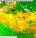
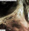
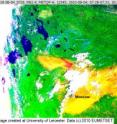
Space scientists at the University of Leicester have released satellite images of vast plumes of smoke emanating from the peat bog fires which are currently sweeping across central and western Russia. Using equipment on the European satellite MetOp-A researchers from the University's Earth Observation Science group have analysed and released still images taken on 4, 8 and 9 August.
Each satellite image is available as both a true colour image and as a false colour version in which the smoke shows up as yellow. Using this technique, the extent of the smoke plumes and their encirclement of Moscow becomes obvious.
As well as demonstrating the massive extent of the smoke clouds across Western Russia, the satellite images indicate another interesting phenomenon: pyrocumulonimbus clouds. These are water clouds, caused by hot air rising directly from a fire, which can trap airborne pollution and transport it for thousands of kilometres. The image from 8 August clearly shows these clouds moving towards Finland in the extreme top left of the picture.
Dr David Moore from the Earth Observation Science Group said,: "Using measurements from spaceborne instruments, we have been able to observe the vast extent of the smoke released from numerous wildfires in Western Russia. The pollutants contained within these smoke plumes can have a profound effect on both the local and regional air quality and atmospheric chemistry. A key aspect of our ongoing investigations will be to quantify the impact the fires have had on indirect greenhouse gases in the atmosphere, such as carbon monoxide."
The Earth Observation Science (EOS) group is based in the University of Leicester's Space Research Centre and includes staff from the Department of Physics and Astronomy, the Department of Chemistry and the Department of Geography. Earlier this year the EOS group released satellite images of the volcanic ice clouds which enveloped Europe after an eruption in Iceland.
Source: University of Leicester
Other sources
- Russian Wildfires Create Towering Dirty Cloudsfrom Live ScienceFri, 13 Aug 2010, 16:21:19 UTC
- Fires around Moscow: A satellite perspectivefrom PhysorgFri, 13 Aug 2010, 14:42:21 UTC
- Fires around Moscow: A satellite perspectivefrom Science BlogFri, 13 Aug 2010, 14:21:28 UTC
- Fires around Moscow: Satellite perspective reveals startling images of massive smoke cloudsfrom Science DailyFri, 13 Aug 2010, 13:21:28 UTC


