NASA watches as Hurricane Bill sweeps over Bermuda
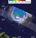
Hurricane Bill was raining on Bermuda on Friday, August 21, 2009, and NASA satellites were providing forecasters with information about Bill's rainfall, clouds and winds. NASA and the Japanese Space Agency's Tropical Rainfall Measuring Mission (TRMM) satellite flew over the center of Hurricane Bill on August 21, 2009 at 0225 UTC (August 17 at 10:25 p.m. EDT) capturing rainfall data.
TRMM rainfall images are false-colored with yellow, green and red areas, which indicate rainfall between 20 and 40 millimeters (.78 to 1.57 inches) per hour. TRMM captured Hurricane Bill's heavy rainfall on August 21 at 5:22 a.m. EDT. The yellow, green and red areas indicate rainfall between .78 to 1.57 inches per hour. The red and purple areas around Bill's eye are considered moderate to heavy rainfall.
According to the National Hurricane Center, Bill is expected to produce total rain accumulations of 1 to 3 Inches over Bermuda, with maximum amounts of 5 inches. Both a hurricane and tropical storm watch are in effect for Bermuda as the rain continues.
For live radar of Bermuda, from the Bermuda Weather Service, visit: http://www.weather.bm/radarLarge.asp
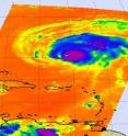
The Aqua satellite also flew over Hurricane Bill early today, Friday, August 21, and provided valuable data on his cloud top temperatures. They're important because they tell forecasters how high thunderstorms are, and the higher the thunderstorm, the more powerful it is, and Bill is pretty powerful as a Category Three Hurricane on the Saffir-Simpson Scale.
In infrared imagery, NASA's false-colored purple clouds are as cold as or colder than 220 Kelvin or minus 63 degrees Fahrenheit (F). The blue colored clouds are about 240 Kelvin, or minus 27F. The colder the clouds are, the higher they are, and the more powerful the thunderstorms are that make up the cyclone.
Although Bill has weakened slightly over the last 24 hours, forecasters say it could regain a little strength before winds and cooler waters start battering it and weakening it. Bill is forecast to parallel the eastern U.S. coast and affect Nova Scotia, Canada, on its curved track into the North Atlantic Ocean this weekend. As Bill approaches the Canadian Maritimes it will undergo a transition into an extra-tropical storm.
At 11 a.m. EDT, Hurricane Bill had maximum sustained winds near 115 mph. He was moving northwest near 18 mph and is expected to turn to the north-northwest later today. His center is currently near latitude 27.6 north and longitude 66.3 west or about 335 miles south-southwest of Bermuda and about 755 miles southeast of Cape Hatteras, North Carolina. Minimum central pressure is 958 millibars.
Meanwhile a warning is in effect now about large, and dangerous ocean swells for a huge area in the eastern Atlantic. Large swells associated with Bill will be impacting the coasts of Puerto Rico; Hispaniola; the Bahamas; Bermuda the entire eastern United States; and the Canadian Maritimes. The National Hurricane Center warns "These swells will likely cause extremely dangerous surf and life-threatening rip currents. Please consult output from your local weather office for details."
Source: NASA/Goddard Space Flight Center
Articles on the same topic
- NASA's QuikScat sees category 3 Hurricane Bill's winds go a long distanceThu, 20 Aug 2009, 18:43:04 UTC
- NASA's Aqua satellite gets 2 views of category 4 Hurricane BillWed, 19 Aug 2009, 14:30:34 UTC
- NASA's TRMM satellite sees wide-eyed Hurricane Bill strengtheningTue, 18 Aug 2009, 17:09:39 UTC
- 2 NASA satellites captures Hurricane Bill's 'baby pictures'Mon, 17 Aug 2009, 19:08:40 UTC
Other sources
- NASA watches as Hurricane Bill sweeps over Bermudafrom Science BlogSat, 22 Aug 2009, 17:49:20 UTC
- NASA watches as Hurricane Bill sweeps over Bermudafrom PhysorgFri, 21 Aug 2009, 21:28:18 UTC
- NASA watches as Hurricane Bill sweeps over Bermudafrom Science BlogFri, 21 Aug 2009, 20:28:06 UTC
- NASA's QuikScat sees category 3 Hurricane Bill's winds go a long distancefrom PhysorgThu, 20 Aug 2009, 19:14:07 UTC
- Hurricane Bill Update: Now a Major Storm, Beating Oddsfrom National GeographicWed, 19 Aug 2009, 21:21:06 UTC
- NASA's Aqua satellite gets 2 views of category 4 Hurricane Billfrom Science BlogWed, 19 Aug 2009, 16:07:29 UTC
- NASA's Aqua satellite gets two views of category 4 Hurricane Billfrom PhysorgWed, 19 Aug 2009, 15:14:08 UTC
- NASA's TRMM satellite sees wide-eyed Hurricane Bill strengtheningfrom PhysorgTue, 18 Aug 2009, 17:07:22 UTC
- 2 NASA satellites capture Hurricane Bill's 'baby pictures'from PhysorgMon, 17 Aug 2009, 20:35:50 UTC
- Hurricane Bill to Be Major, But Projected Path Is Hazyfrom National GeographicMon, 17 Aug 2009, 20:28:06 UTC
- 2 NASA satellites captures Hurricane Bill's 'baby pictures'from Science BlogMon, 17 Aug 2009, 19:21:44 UTC
- First Atlantic Hurricane Gains Strengthfrom Live ScienceMon, 17 Aug 2009, 17:49:12 UTC

