NASA's TRMM satellite sees wide-eyed Hurricane Bill strengthening
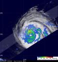
The TRMM satellite noticed a wide-eyed Hurricane Bill's rainfall is intensifying indicating he's getting stronger. Satellite images have also shown Bill's eye is widening. NASA and the Japanese Space Agency's Tropical Rainfall Measuring Mission (TRMM) satellite flew over the center of Hurricane Bill on August 18, 2009 at 0225 UTC (August 17 at 10:25 p.m. EDT) capturing rainfall data.
TRMM rainfall images are false-colored with yellow, green and red areas, which indicate rainfall between 20 and 40 millimeters (.78 to 1.57 inches) per hour. Red areas are considered moderate rainfall.
The TRMM rainfall analysis from the TRMM Microwave Imager (TMI) and Precipitation Radar (PR) instruments reveal that hurricane Bill has an eye. This feature isn't apparent on the TRMM Infrared image (VIRS) but is evidence of Bill becoming a stronger category two hurricane with wind speeds increasing to about 85 knots (~98 miles per hour). In fact, satellite imagery shows that Bill's eye is quite large, between 35-45 nautical miles in diameter!
At 11 a.m. EDT, Hurricane Bill had maximum sustained winds near 105 mph, making him a Category Two on the Saffir-Simpson Scale. He is expected to strengthen into a Category Three hurricane, a major hurricane, with winds in excess of 110 mph. Bill was centered about 705 miles east of the Leeward Islands, near 15.9 north and 51.2 west. He was heading west-northwest near 16 mph with a minimum central pressure of 963 millibars.
Interests in the Leeward Islands should monitor Bill's progress, as his track is currently expected to remain at sea and sweep past them and head in a northwesterly direction over the next two days.
Source: NASA/Goddard Space Flight Center
Articles on the same topic
- NASA watches as Hurricane Bill sweeps over BermudaFri, 21 Aug 2009, 19:07:44 UTC
- NASA's QuikScat sees category 3 Hurricane Bill's winds go a long distanceThu, 20 Aug 2009, 18:43:04 UTC
- NASA's Aqua satellite gets 2 views of category 4 Hurricane BillWed, 19 Aug 2009, 14:30:34 UTC
- 2 NASA satellites captures Hurricane Bill's 'baby pictures'Mon, 17 Aug 2009, 19:08:40 UTC
Other sources
- NASA watches as Hurricane Bill sweeps over Bermudafrom Science BlogSat, 22 Aug 2009, 17:49:20 UTC
- NASA watches as Hurricane Bill sweeps over Bermudafrom PhysorgFri, 21 Aug 2009, 21:28:18 UTC
- NASA watches as Hurricane Bill sweeps over Bermudafrom Science BlogFri, 21 Aug 2009, 20:28:06 UTC
- NASA's QuikScat sees category 3 Hurricane Bill's winds go a long distancefrom PhysorgThu, 20 Aug 2009, 19:14:07 UTC
- Hurricane Bill Update: Now a Major Storm, Beating Oddsfrom National GeographicWed, 19 Aug 2009, 21:21:06 UTC
- NASA's Aqua satellite gets 2 views of category 4 Hurricane Billfrom Science BlogWed, 19 Aug 2009, 16:07:29 UTC
- NASA's Aqua satellite gets two views of category 4 Hurricane Billfrom PhysorgWed, 19 Aug 2009, 15:14:08 UTC
- NASA's TRMM satellite sees wide-eyed Hurricane Bill strengtheningfrom PhysorgTue, 18 Aug 2009, 17:07:22 UTC
- 2 NASA satellites capture Hurricane Bill's 'baby pictures'from PhysorgMon, 17 Aug 2009, 20:35:50 UTC
- Hurricane Bill to Be Major, But Projected Path Is Hazyfrom National GeographicMon, 17 Aug 2009, 20:28:06 UTC
- 2 NASA satellites captures Hurricane Bill's 'baby pictures'from Science BlogMon, 17 Aug 2009, 19:21:44 UTC
- First Atlantic Hurricane Gains Strengthfrom Live ScienceMon, 17 Aug 2009, 17:49:12 UTC
