NASA spots Central Pacific's Madeline strengthening into a hurricane
Related images
(click to enlarge)
As Hurricane Lester in the Eastern Pacific Ocean strengthened into a major hurricane, Tropical Storm Madeline in the Central Pacific became a hurricane. NASA-NOAA's Suomi NPP satellite captured an image as Madeline was transitioning and organizing. On Aug. 27 at 11 a.m. EDT (1500 UTC) Tropical Storm Madeline developed just east of the 140 degree longitude line in the Eastern Pacific Ocean located near latitude 15.2 degrees north latitude and 138.5 degrees west longitude. Since that time, it crossed that longitude line and entered the Central Pacific Ocean Basin.
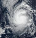
When NASA-NOAA's Suomi NPP satellite passed over Madeline it was strengthening into a hurricane. On Aug. 28 at 6:05 p.m. EDT (2205 UTC) the Visible Infrared Imaging Radiometer Suite (VIIRS) instrument aboard NASA-NOAA's Suomi NPP satellite captured an image of Tropical Storm Madeline as it was strengthening and organizing.The image showed the system had a good circulation and a band of strong thunderstorms wrapping tightly into the low-level center from the west. Madeline had taken on a comma shape.
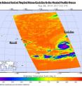
When NASA's Aqua satellite passed over the Central Pacific Ocean it gathered temperature data on Tropical Storm Madeline. The Atmospheric Infrared Sounder or AIRS instrument aboard Aqua looked at Madeline in infrared light on Aug. 28 at 7:11 p.m. EDT (2311 UTC). AIRS infrared data showed that the depression had some powerful thunderstorms with high cold cloud tops (as cold as minus 63 degrees Fahrenheit or minus 53 degrees Celsius).
On Aug. 29 at 5 a.m. EDT (0900 UTC), Madeline strengthened into a hurricane. At 11 a.m. EDT (5 a.m. HST/1500 UTC), the center of Hurricane Madeline was located near 18.2 degrees north latitude and 144.6 degrees west longitude. Maximum sustained winds are near 100 mph (155 km/h) with higher gusts. Slight strengthening is expected later today and Tuesday, followed by slight weakening early Wednesday. The estimated minimum central pressure is 975 millibars.
Madeline is moving toward the west-northwest near 10 mph (17 kph) and this motion is expected to become westerly later today through early Wednesday.
Forecaster Powell at NOAA's Central Pacific Hurricane Center (CPHC) mentioned in the discussion issued at that time that "Madeline's cloud-covered eye re-emerged by 8 a.m. EDT (1200 UTC) with a cooler-topped and increasingly well-formed eyewall. Organization continues to improve, with little or no [vertical wind] shear deformation present."
CPHC noted that there are no coastal watches or warnings in effect, however, interests in the Hawaiian Islands should monitor the progress of Madeline.
For updated forecasts on Madeline, visit the CPHC website: http://www.prh.noaa.gov/cphc
Source: NASA/Goddard Space Flight Center
Articles on the same topic
- NASA observes a weaker Tropical Cyclone Gaston, warnings up in AzoresFri, 2 Sep 2016, 16:06:28 UTC
- NASA satellite sees Hurricane Gaston headed toward the AzoresThu, 1 Sep 2016, 14:56:19 UTC
- NASA observes large eye of Hurricane GastonThu, 1 Sep 2016, 11:04:28 UTC
- NASA sees Lester strengthening into fourth major Eastern Pacific hurricaneMon, 29 Aug 2016, 18:04:26 UTC
- NASA eyes powerful Hurricane Gaston almost 600 miles from BermudaMon, 29 Aug 2016, 15:36:55 UTC
- Two NASA satellites take a bead on Gaston's movementsFri, 26 Aug 2016, 18:44:21 UTC
- NASA's GPM examines Tropical Storm LesterFri, 26 Aug 2016, 16:16:47 UTC
- NASA sees heavy rain in Gaston as it fights wind shearFri, 26 Aug 2016, 6:53:56 UTC
Other sources
- NASA observes a weaker Tropical Cyclone Gaston, warnings up in Azoresfrom PhysorgFri, 2 Sep 2016, 16:31:19 UTC
- NASA satellite sees Hurricane Gaston headed toward the Azoresfrom PhysorgThu, 1 Sep 2016, 15:01:30 UTC
- NASA observes large eye of Hurricane Gastonfrom PhysorgWed, 31 Aug 2016, 16:31:36 UTC
- NASA eyes powerful Hurricane Gaston almost 600 miles from Bermudafrom PhysorgMon, 29 Aug 2016, 16:01:23 UTC
- NASA sees Lester strengthening into fourth major Eastern Pacific hurricanefrom PhysorgMon, 29 Aug 2016, 16:01:22 UTC
- Tropical depression forms off Carolinas coast as disturbance gains strengthfrom UPISun, 28 Aug 2016, 17:21:13 UTC
- Two NASA satellites take a bead on Gaston's movementsfrom PhysorgFri, 26 Aug 2016, 21:41:45 UTC
- NASA sees heavy rain in Gaston as it fights wind shearfrom PhysorgFri, 26 Aug 2016, 6:51:15 UTC
- Tropical wave '99L' remains disorganized while Hurricane Gaston expected to weakenfrom UPIThu, 25 Aug 2016, 14:31:22 UTC
- Hurricane Gaston expected to weaken; next storm could organize Thursdayfrom UPIThu, 25 Aug 2016, 13:01:26 UTC
- Gaston expected to become hurricane Wednesday; disturbance strengthensfrom UPIWed, 24 Aug 2016, 15:31:12 UTC
- Tropical Storm Gaston to turn into hurricane by Wednesdayfrom UPITue, 23 Aug 2016, 11:31:20 UTC

