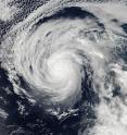
NASA sees Lester strengthening into fourth major Eastern Pacific hurricane
NOAA's Suomi NPP satellite passed over hurricane Lester it was on the verge of becoming a major hurricane. That happened less than 12 hours later. On Aug. 28 at 6:05 p.m. EDT (2205 UTC) the Visible Infrared Imaging Radiometer Suite (VIIRS) instrument aboard NASA-NOAA's Suomi NPP satellite captured an image of Hurricane Lester as it was strengthening and organizing in the Eastern Pacific Ocean. The image showed the system was developing a well-defined circulation and a cloud-filled eye. The image also revealed strong thunderstorms wrapping tightly into the low-level center.
Less than 12 hours later by 5 a.m. EDT on Aug. 29, Lester became a major hurricane hitting Category 3 status on the Saffir-Simpson Hurricane Wind Scale. At that time the ragged eye that had formed earlier had cleared out, exposing the eye to satellites. Lester has become the fourth major hurricane of the 2016 eastern North Pacific hurricane season.
At 5 a.m. EDT (0900 UTC), the center of Hurricane Lester was located near 18.0 degrees north latitude and 127.8 degrees west longitude, about 1,205 miles (1,940 km) west-southwest of the southern tip of Baja California, Mexico.
The National Hurricane Center (NHC) said that Lester is moving toward the west near 15 mph (24 kph), and this general motion is expected to continue for the next couple of days. Maximum sustained winds have increased to near 115 mph (185 kph) with higher gusts.
NHC forecasters noted that little change in strength is expected today, but slow weakening is expected to begin by Tuesday, Aug. 30.
Source: NASA/Goddard Space Flight Center
Articles on the same topic
- NASA observes a weaker Tropical Cyclone Gaston, warnings up in AzoresFri, 2 Sep 2016, 16:06:28 UTC
- NASA satellite sees Hurricane Gaston headed toward the AzoresThu, 1 Sep 2016, 14:56:19 UTC
- NASA observes large eye of Hurricane GastonThu, 1 Sep 2016, 11:04:28 UTC
- NASA spots Central Pacific's Madeline strengthening into a hurricaneMon, 29 Aug 2016, 18:04:37 UTC
- NASA eyes powerful Hurricane Gaston almost 600 miles from BermudaMon, 29 Aug 2016, 15:36:55 UTC
- Two NASA satellites take a bead on Gaston's movementsFri, 26 Aug 2016, 18:44:21 UTC
- NASA's GPM examines Tropical Storm LesterFri, 26 Aug 2016, 16:16:47 UTC
- NASA sees heavy rain in Gaston as it fights wind shearFri, 26 Aug 2016, 6:53:56 UTC
Other sources
- NASA observes a weaker Tropical Cyclone Gaston, warnings up in Azoresfrom PhysorgFri, 2 Sep 2016, 16:31:19 UTC
- NASA satellite sees Hurricane Gaston headed toward the Azoresfrom PhysorgThu, 1 Sep 2016, 15:01:30 UTC
- NASA observes large eye of Hurricane Gastonfrom PhysorgWed, 31 Aug 2016, 16:31:36 UTC
- NASA eyes powerful Hurricane Gaston almost 600 miles from Bermudafrom PhysorgMon, 29 Aug 2016, 16:01:23 UTC
- NASA sees Lester strengthening into fourth major Eastern Pacific hurricanefrom PhysorgMon, 29 Aug 2016, 16:01:22 UTC
- Tropical depression forms off Carolinas coast as disturbance gains strengthfrom UPISun, 28 Aug 2016, 17:21:13 UTC
- Two NASA satellites take a bead on Gaston's movementsfrom PhysorgFri, 26 Aug 2016, 21:41:45 UTC
- NASA sees heavy rain in Gaston as it fights wind shearfrom PhysorgFri, 26 Aug 2016, 6:51:15 UTC
- Tropical wave '99L' remains disorganized while Hurricane Gaston expected to weakenfrom UPIThu, 25 Aug 2016, 14:31:22 UTC
- Hurricane Gaston expected to weaken; next storm could organize Thursdayfrom UPIThu, 25 Aug 2016, 13:01:26 UTC
- Gaston expected to become hurricane Wednesday; disturbance strengthensfrom UPIWed, 24 Aug 2016, 15:31:12 UTC
- Tropical Storm Gaston to turn into hurricane by Wednesdayfrom UPITue, 23 Aug 2016, 11:31:20 UTC
