New study analyzes the risk to endangered whales from ships in southern California
Related images
(click to enlarge)
Researchers have identified areas off southern California with high numbers of whales and assessed their risk from potentially deadly collisions with commercial ship traffic in a study released today in the scientific journal Conservation Biology. Scientists from NOAA Fisheries, the Marine Mammal Commission and Cascadia Research Collective analyzed data collected over seven years by NOAA on marine mammal and ecosystem research surveys in the Southern California Bight. Maps predicting the density of endangered humpback, fin and blue whales were developed by merging the observed whale sightings with oceanographic conditions to identify the habitat preferred by the different whale species.
"We know several endangered species of whales occur in the waters off southern California," said Jessica Redfern, a NOAA Fisheries marine mammal biologist and lead author of the paper. "What we didn't know, and what this study helps provide, is an understanding of the areas with the highest numbers of whales."
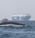
Knowing where whales are more likely to be found in the ocean environment is vitally important to reduce human impacts. Although this information could be used to assess any number of human impacts, the study specifically looked at current and alternative shipping routes to and from the Ports of Los Angeles and Long Beach and the risk to humpback, fin and blue whales from ship strikes.
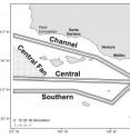
Researchers selected four routes to study; the shipping route in the Santa Barbara Channel, which is the current shipping route; a Central route south of the northern Channel Islands; a Central Fan route, or just the eastern part of the Central route; and a Southern route, a course south of the Central route and constrained by the protected areas around Santa Barbara, Santa Catalina, and San Nicolas Islands.
By overlaying the routes with the predicted whale densities, researchers found the route with the lowest risk for humpback whales (Southern route) had the highest risk for fin whales and vice versa. However, risk may be ameliorated for both species in one of the Central routes. Blue whales, however, were at approximately equal risk in all routes considered because of their more even distribution throughout the study area. The authors' estimate of the number of blue whales likely killed by ships exceeds levels established by the Marine Mammal Protection Act to ensure sustainable populations. This result suggests that it is important to find ways to reduce the risk of ships striking blue whales.
"The Southern California Bight is an incredibly complex system with a diverse set of users, including the military, shipping industry and fishing industry. All users have specific needs and their input is necessary to plan the best and safest uses of these waters," said Redfern, "This paper helps to incorporate whale habitat use in the planning process so that their needs can be considered as well."
Source: NOAA National Marine Fisheries Service
Other sources
- New study analyzes the risk to endangered whales from ships in southern Californiafrom Science DailyTue, 26 Mar 2013, 2:00:31 UTC
- Ship risks to whales in S. Calif. studiedfrom UPITue, 26 Mar 2013, 1:30:15 UTC
- New study analyzes the risk to endangered whales from ships in southern Californiafrom PhysorgMon, 25 Mar 2013, 21:02:18 UTC


