NASA: Songda becomes a super typhoon
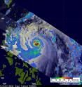
As predicted, Typhoon Songda intensified and was a super typhoon with wind speeds estimated at over 130 knots ( ~145 mph) when NASA's TRMM satellite passed directly over head on May 26, 2011 at 0806 UTC (4:06 a.m. EDT). The Tropical Rainfall Measuring Mission (TRMM) satellite captured the heavy rainfall rates within the super typhoon using TRMM's Visible and InfraRed Scanner (VIRS) instrument. The rainfall analysis from TRMM's Microwave Imager (TMI) and Precipitation Radar (PR) data showed that Songda had a circular eye with extremely heavy rainfall (as much as 2 inches/50 mm per hour) particularly in the southeast quadrant. TRMM's PR instrument data showed the concentric rain bands typical of powerful typhoons.
Warnings are in effect in the Philippines today. Public storm warning signal no 1 is in effect in the following provinces: Luzon: Catanduanes, Camarines Sur & Norte, Quirino, Albay, Aurora, Quezon Provinces, Polilio Island, Cagayan and Isabela.
At 1500 UTC (11 a.m. EDT) on May 26, Super Typhoon Songda (called Chedeng in the Philippines) had maximum sustained winds near 140 knots (161 mph/259 kmh). Typhoon-strength winds extend 45 miles out from the center, while tropical storm-force winds extend 155 miles from the center, making Songda over 300 miles wide.
Songda's center was 250 miles east-northeast of Manila, near 16.2 North and 125.1 East. It was moving northwest near 8 knots (9 mph/15 kmh). Songda is creating very rough and dangerous seas in Philippine Sea, with wave heights reaching 38 feet (11.5 meters).
Songda has intensified in favorable conditions as the forecasters at the Joint Typhoon Warning Center predicted. Songda may have reached its peak intensity and is forecast to start turning to the northeast and weaken because of increased wind shear.
Songda will then start to veer northeast and weaken due to deteriorating atmospheric conditions.
Taiwan has already posted Marine Warnings for May 27 and 28, forecasting wave heights to increase from 2 meters (~6.5 feet) to as much as 6 meters (~20 feet) on east-facing shorelines as Super Typhoon Sondga moves past (it will stay off-shore and track to the east of Taiwan). The current track from the Joint Typhoon Warning Center takes Songda over the island of Kadena on May 28, and then skirting the east coast of Japan as it continues on a northeasterly track over the weekend.
Source: NASA/Goddard Space Flight Center
Articles on the same topic
- NASA sees a 14-mile-wide eye and powerful Super Typhoon SongdaFri, 27 May 2011, 20:05:33 UTC
- NASA's TRMM satellite sees a well-organized, major Typhoon SongdaWed, 25 May 2011, 21:38:26 UTC
- NASA's infrared satellite imagery shows a stronger Typhoon SongdaWed, 25 May 2011, 14:35:42 UTC
- NASA sees Tropical Storm Songda singing of rain and gusty winds for the PhilippinesWed, 25 May 2011, 14:35:30 UTC
Other sources
- NASA sees a 14-mile-wide eye and powerful Super Typhoon Songdafrom PhysorgFri, 27 May 2011, 20:31:34 UTC
- NASA: Songda becomes a super typhoonfrom PhysorgThu, 26 May 2011, 21:30:30 UTC
- NASA's TRMM satellite sees a well-organized, major Typhoon Songdafrom PhysorgWed, 25 May 2011, 21:30:41 UTC
- NASA's infrared satellite imagery shows a stronger Typhoon Songdafrom PhysorgWed, 25 May 2011, 14:30:35 UTC
- NASA sees Tropical Storm Songda singing of rain and gusty winds for the Philippinesfrom PhysorgTue, 24 May 2011, 13:01:16 UTC
