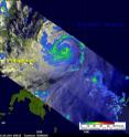
NASA's TRMM satellite sees a well-organized, major Typhoon Songda
Typhoon Songda was east of the Philippines when the Tropical Rainfall Measuring Mission (TRMM) satellite had an early evening view on May 25, 2011 at 0903 UTC (05:03 EDT) and saw good organization within the storm and heavy rainfall. Songda has intensified into a major typhoon as it tracks parallel to the east coast of the northern Philippines, spawning warnings. Both TRMM's Microwave Imager (TMI) and Precipitation Radar (PR) instruments were used to provide the rainfall analysis. TRMM's TMI had the best coverage of rainfall with Songda and showed well organized bands of moderate to heavy rainfall converging into the typhoon. TRMM is managed by both NASA and the Japanese Space Agency, JAXA.
Infrared imagery from the Atmospheric Infrared Sounder (AIRS) instrument on NASA's Aqua satellite showed an eye about 12 nautical miles wide and strong convection surrounding the eye on all sides. Songda intensified over the over the last 12 hours because of very warm sea surface temperatures between 30 and 31 Celsius, and low wind shear.
At 1500 UTC (11 a.m. EDT) on May 25, Songda's maximum sustained winds were near 105 knots (120 mph/194 kmh) making it a Category Three Typhoon on the Saffir-Simpson scale. Sondga was located about 385 nautical miles east-southeast of Manila, Philippines and is now moving northwestward near 5 knots (6 mph/9 kmh). Yesterday it was moving to the west-northwest, so the curving northward has already begun.
Songda is predicted to become a very powerful category 4 super typhoon with wind speeds peaking at 125 knots (143 mph/231 kmh) as it passes to the northeast of the Philippines. By Friday, the current forecast track takes Songda's center very close to the island with Kadena Air Base in the Northwestern Pacific Ocean.
Source: NASA/Goddard Space Flight Center
Articles on the same topic
- NASA sees a 14-mile-wide eye and powerful Super Typhoon SongdaFri, 27 May 2011, 20:05:33 UTC
- NASA: Songda becomes a super typhoonThu, 26 May 2011, 21:33:15 UTC
- NASA's infrared satellite imagery shows a stronger Typhoon SongdaWed, 25 May 2011, 14:35:42 UTC
- NASA sees Tropical Storm Songda singing of rain and gusty winds for the PhilippinesWed, 25 May 2011, 14:35:30 UTC
Other sources
- NASA sees a 14-mile-wide eye and powerful Super Typhoon Songdafrom PhysorgFri, 27 May 2011, 20:31:34 UTC
- NASA: Songda becomes a super typhoonfrom PhysorgThu, 26 May 2011, 21:30:30 UTC
- NASA's TRMM satellite sees a well-organized, major Typhoon Songdafrom PhysorgWed, 25 May 2011, 21:30:41 UTC
- NASA's infrared satellite imagery shows a stronger Typhoon Songdafrom PhysorgWed, 25 May 2011, 14:30:35 UTC
- NASA sees Tropical Storm Songda singing of rain and gusty winds for the Philippinesfrom PhysorgTue, 24 May 2011, 13:01:16 UTC
