NASA's TRMM Satellite sees Zelia born of System 94P
The low pressure area known as System 94P on January 13 strengthened into the seventh tropical cyclone of the South Pacific Cyclone season, today becoming Tropical Storm Zelia. NASA's TRMM satellite found heavy rainfall was already occurring in the storm as it was turning away from New Zealand and heading toward New Caledonia. New Caledonia just dealt with Tropical Storm Vince today, and is expecting to feel winds and rains from Tropical Storm Zelia as it passes to the southwest of the island group this weekend.
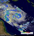
The Tropical Rainfall Measuring Mission (TRMM) satellite, managed by NASA and the Japanese Space Agency flew over Tropical Storm Zelia on January 14 at 0417 UTC (Jan. 13 at 11:17 p.m. EST). TRMM noticed that the heaviest rainfall (falling at about 2 inches/50 mm per hour) appeared to be on the northwestern and southwestern sides of the storm.
TRMM images are pretty complicated to create. They're made at NASA's Goddard Space Flight Center in Greenbelt, Md. At Goddard, rain rates in the center of the swath (the satellite's orbit path over the storm) are created from the TRMM Precipitation Radar (PR) instrument. The TRMM PR is the only space borne radar of its kind. The rain rates in the outer portion of the storm are created from a different instrument on the satellite, called the TRMM Microwave Imager (TMI). The rain rates are then overlaid on infrared (IR) data from the TRMM Visible Infrared Scanner (VIRS). For more information about TRMM, visit: http://www.trmm.gsfc.nasa.gov/.
Infrared satellite imagery shows strong convection (rapidly rising air that condenses and forms the thunderstorms that power the tropical cyclone) consolidating over the western quadrant and near the center. The storm appears well-organized as bands of thunderstorms wrapping around the center were also evident in satellite imagery.
At 1500 UTC (10 a.m. EST/ 2 a.m. on Jan. 15, Pacific/Noumea local time) Tropical Storm Zelia had maximum sustained winds near 55 knots (63 mph/101 km/hr) with higher gusts. Zelia's center was located about 860 nautical miles north of Brisbane, Australia near 13.4 South and 152.3 East. Zelia is moving southeastward near 9 knots (10 mph/~16 km/hr).
The Joint Typhoon Warning Center expects Zelia to continue moving in a general southeastern direction and strengthen into a cyclone before becoming extra-tropical.
Source: NASA/Goddard Space Flight Center
Articles on the same topic
- NASA's Aqua sees Tropical Storm Vince about to U-turn away from AustraliaFri, 14 Jan 2011, 21:32:39 UTC
- NASA satellite: Tropical Storm Vania brought heavy rains to southeastern New CaledoniaFri, 14 Jan 2011, 21:32:34 UTC
- NASA's Aqua Satellite sees tropical potential in system 94PFri, 14 Jan 2011, 15:07:19 UTC
- NASA satellites dissect Tropical Storm Vania's clouds and rainfallFri, 14 Jan 2011, 15:07:18 UTC
Other sources
- NASA's Aqua sees Tropical Storm Vince about to U-turn away from Australiafrom PhysorgFri, 14 Jan 2011, 23:00:26 UTC
- NASA's TRMM Satellite sees Zelia born of System 94Pfrom PhysorgFri, 14 Jan 2011, 23:00:25 UTC
- NASA satellite: Tropical Storm Vania brought heavy rains to southeastern New Caledoniafrom PhysorgFri, 14 Jan 2011, 23:00:24 UTC
- NASA’s TRMM Satellite sees Zelia born of System 94Pfrom Science BlogFri, 14 Jan 2011, 22:31:32 UTC
- NASA satellite: Tropical Storm Vania brought heavy rains to southeastern New Caledoniafrom Science BlogFri, 14 Jan 2011, 22:31:31 UTC
- NASA’s Aqua sees Tropical Storm Vince about to U-turn away from Australiafrom Science BlogFri, 14 Jan 2011, 22:31:30 UTC
- NASA's Aqua Satellite sees tropical potential in system 94Pfrom PhysorgFri, 14 Jan 2011, 15:02:45 UTC
- NASA satellites dissect Tropical Storm Vania's clouds and rainfallfrom PhysorgFri, 14 Jan 2011, 15:00:47 UTC
- NASA satellites dissect Tropical Storm Vania’s clouds and rainfallfrom Science BlogFri, 14 Jan 2011, 15:00:25 UTC
- NASA’s Aqua Satellite sees tropical potential in system 94Pfrom Science BlogFri, 14 Jan 2011, 15:00:24 UTC
