NASA satellites dissect Tropical Storm Vania's clouds and rainfall
NASA's Tropical Rainfall Measuring Mission (TRMM) and Aqua satellites are providing valuable information to forecasters about Tropical Storm Vania's clouds and rainfall as the system continues to impact Vanuatu and New Caledonia in the South Pacific. Using precipitation radar, infrared and visible technology, the two NASA satellites provided rainfall rates, cloud heights and temperatures.
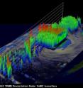
The TRMM satellite had a very good daytime look at tropical cyclone Vania in the South Pacific Ocean near Vanuatu on January 12, 2011 at 0435 UTC (11:35 p.m. EST Jan. 11). Top wind speeds were estimated at about 45 knots ( ~52 mph) indicating that it was tropical storm strength on the Saffir-Simpson scale.
TRMM's Precipitation Radar (PR) data was used to make a 3-D image that showed Vania had some thunderstorms that reached to heights of about 15 kilometers (~9.3 miles). Vania has been forecast to attain minimal hurricane force with wind speeds up to 65 knots (~74.8 mph) on January 14.
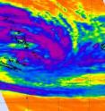
An infrared image from the NASA's Atmospheric Infrared Sounder (AIRS) instrument aboard NASA's Aqua satellite captured on Jan. 13 at 211 UTC showed that the strongest convection or heaviest rainfall and strongest thunderstorms were mostly east of Vanuatu and over open waters. Cloud top temperatures there were as cold as or colder than -63 Fahrenheit. The visible image from NASA's Aqua satellite showed shows a well-developed tropical storm with a signature swirl of clouds.
At 0900 UTC (4 a.m. EST) on January 13, Tropical Storm Vania had maximum sustained winds near 69 mph (111 km/hour). Tropical storm force winds extend out from the center up to 90 miles making the storm about 180 miles in diameter. It was located about 150 miles north-northeast of Noumeau, New Caledonia near 20.2 South and 167.8 East. Vania is moving southwestward near 7 mph (11 km/hr).
Warnings remain in effect. Vanuatu warnings include: A Red Alert for Tafea province and a Yellow Alert for Shefa province. In New Caledonia, warnings are in effect for The Loyauté (a Red alert) and the Grande Terre is on Yellow alert south of Poya and Penerihouen. For updated Vanuatu warnings, go to: http://www.meteo.gov.vu/TropicalCyclones/Warning/tabid/172/Default.aspx/. For updated New Caledonian warnings (in French) http://www.meteo.nc/cyclones/cycl_der.php/
Satellite imagery currently indicates that most of the deepest convection is over the southern semicircle of the storm, while convection is limited on the northern side.
Vania continues towards New Caledonia and is forecast to move south and brush the far eastern part of New Caledonia. After passing the main island of New Caledonia, forecasters expect stronger wind shear and cooler sea surface temperatures to sap its strength.
Source: NASA/Goddard Space Flight Center
Articles on the same topic
- NASA's TRMM Satellite sees Zelia born of System 94PFri, 14 Jan 2011, 22:01:51 UTC
- NASA's Aqua sees Tropical Storm Vince about to U-turn away from AustraliaFri, 14 Jan 2011, 21:32:39 UTC
- NASA satellite: Tropical Storm Vania brought heavy rains to southeastern New CaledoniaFri, 14 Jan 2011, 21:32:34 UTC
- NASA's Aqua Satellite sees tropical potential in system 94PFri, 14 Jan 2011, 15:07:19 UTC
Other sources
- NASA's Aqua sees Tropical Storm Vince about to U-turn away from Australiafrom PhysorgFri, 14 Jan 2011, 23:00:26 UTC
- NASA's TRMM Satellite sees Zelia born of System 94Pfrom PhysorgFri, 14 Jan 2011, 23:00:25 UTC
- NASA satellite: Tropical Storm Vania brought heavy rains to southeastern New Caledoniafrom PhysorgFri, 14 Jan 2011, 23:00:24 UTC
- NASA’s TRMM Satellite sees Zelia born of System 94Pfrom Science BlogFri, 14 Jan 2011, 22:31:32 UTC
- NASA satellite: Tropical Storm Vania brought heavy rains to southeastern New Caledoniafrom Science BlogFri, 14 Jan 2011, 22:31:31 UTC
- NASA’s Aqua sees Tropical Storm Vince about to U-turn away from Australiafrom Science BlogFri, 14 Jan 2011, 22:31:30 UTC
- NASA's Aqua Satellite sees tropical potential in system 94Pfrom PhysorgFri, 14 Jan 2011, 15:02:45 UTC
- NASA satellites dissect Tropical Storm Vania's clouds and rainfallfrom PhysorgFri, 14 Jan 2011, 15:00:47 UTC
- NASA satellites dissect Tropical Storm Vania’s clouds and rainfallfrom Science BlogFri, 14 Jan 2011, 15:00:25 UTC
- NASA’s Aqua Satellite sees tropical potential in system 94Pfrom Science BlogFri, 14 Jan 2011, 15:00:24 UTC

