3 NASA satellites capture Typhoon Megi strengthening again
Related images
(click to enlarge)
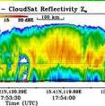
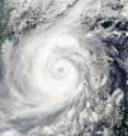
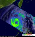
Three NASA satellites are keeping tabs on Typhoon Megi and noticed that it was strengthening in the South China Sea today, but increasing wind shear may again weaken the system over the next couple of days. NASA's TRMM, CloudSat and Aqua satellite captured images of Megi's clouds, rainfall and eye as they passed over the storm and saw clouds higher than 9 miles filled with ice, creating heavy rainfall.
The Tropical Rainfall Measuring Mission (TRMM) satellite passed over Typhoon Megi from its vantage point in space on October 18 at 2321 UTC (7:31 p.m. EDT) and saw that Megi was starting to re-organize after weakening from its encounter with the northern Philippines.
The TRMM team at NASA's Goddard Space Flight Center in Greenbelt, Md. creates rainfall imagery using data from various instruments aboard the satellite. Rain rates in the center of the TRMM swath were created from the TRMM Precipitation Radar (PR), the only spaceborne radar of its kind, while those in the outer portion are from the TRMM Microwave Imager (TMI). To put the image together, the rain rates were then overlaid on infrared data from the TRMM Visible Infrared Scanner. The October 18 TRMM daylight pass showed that Megi's eye was clearer than it was just a few hours earlier and that moderate to heavy rain showers were again completely surrounding the eye indicating it was strengthening at that time.
Also on October 18, NASA's CloudSat satellite passed over Typhoon Megi and the satellite's Cloud Profiling Radar captured a view of the typhoon's clouds from the side. The data gathered from Cloudsat revealed that the cloud tops were over 15 kilometers (9.3 miles) high, and ice was present in them. CloudSat also noticed areas of intense rainfall exceeding 30mm/hr (1.18 inches/hour).
On October 20 at 0530 UTC (1:30 a.m. EDT), the Moderate Resolution Imaging Spectroradiometer (MODIS) instrument on NASA's Aqua satellite captured a visible image of Typhoon Megi as it filled up a large part of the South China Sea. The image revealed an eye filled with high clouds and a very large system.
At 11 a.m. EDT (1500 UTC) on October 20, Typhoon Megi's maximum sustained winds had increased to 110 knots (126 mph). It was about 285 nautical miles south-southeast of Hong Kong, China near 18.7 North and 117.2 East. It was moving north at 8 mph (7 knots). Water vapor imagery has shown that its northern edge is eroding from strong upper level westerly winds. Infrared imagery, such as that from NASA's Atmospheric Infrared Sounder (AIRS) instrument on the Aqua satellite revealed that deep convection around the northern rim of the eyewall is decreasing indicating a weakening trend.
Typhoon Megi is forecast to make landfall on October 23 east of Hong Kong and then rapidly dissipate as a significant tropical cyclone.
Source: NASA/Goddard Space Flight Center
Articles on the same topic
- NASA satellites see Typhoon Megi poised for southeastern China landfallFri, 22 Oct 2010, 21:04:09 UTC
Other sources
- NASA satellites see Typhoon Megi poised for southeastern China landfallfrom Science BlogFri, 22 Oct 2010, 23:20:40 UTC
- NASA satellites see Typhoon Megi poised for southeastern China landfallfrom PhysorgFri, 22 Oct 2010, 23:20:22 UTC
- 3 NASA satellites capture Typhoon Megi strengthening againfrom Science BlogWed, 20 Oct 2010, 21:00:40 UTC
- 3 NASA satellites capture Typhoon Megi strengthening againfrom PhysorgWed, 20 Oct 2010, 20:00:41 UTC
- Typhoon Megi's heavy rainfall witnessed by NASA as it moves into the South China Seafrom PhysorgWed, 20 Oct 2010, 15:32:35 UTC
- Green: On Our Radar: A Super Typhoonfrom NY Times ScienceTue, 19 Oct 2010, 15:50:59 UTC
- What Makes a Storm a Super-Typhoon?from Live ScienceTue, 19 Oct 2010, 1:32:03 UTC


