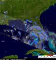
Warnings up for Tropical Depression 5 in the eastern Gulf of Mexico
One of the two systems that forecasters have been closely watching in the Atlantic Ocean Basin became the fifth tropical depression at 7:30 p.m. EDT on August 10 in the northeastern Gulf of Mexico. NASA's TRMM satellite confirmed better organization in the system's rainbands just before it was classified as a tropical depression. System 94L is now Tropical Depression 5 (TD5), and is forecast to strengthen into Tropical Storm Danielle in the next day or so.
The Tropical Rainfall Measuring Mission (TRMM) satellite passed above TD5 on August 10 at 2226 UTC (6:22 p.m. EDT). The rainfall pattern was analyzed using data from TRMM's Precipitation Radar (PR) and TRMM Microwave Imager (TMI) instrument data. The precipitation pattern showed that TD5 was slightly better organized than earlier, helping forecasters with the decision to classify the system as a tropical depression. TRMM is a joint mission between NASA and the Japanese Space Agency, JAXA.
The National Hurricane Center issued a tropical storm warning from Destin, Florida to Intracoastal City Louisiana, including Lake Pontchartrain and New Orleans. That means tropical storm conditions are expected within the warning area in 36 hours. Heavy rain, tropical storm force winds and a storm surge between 2 and 4 feet near landfall and east of landfall are forecast.
At 5 a.m. EDT on August 11, Tropical Depression 5 (TD5) had maximum sustained winds near 35 mph, and slow strengthening is expected. It was centered near 26.8 north latitude and 85.1 west longitude. Estimated minimum central pressure is 1008 millibars. It is expected to continue moving northwest near 10 mph today, and slow on Thursday, August 12 when it will be approaching the north central Gulf of Mexico in the morning.
Source: NASA/Goddard Space Flight Center
Articles on the same topic
- NASA's Aqua Satellite sees TD5's remnants stretched out in US southThu, 19 Aug 2010, 19:08:19 UTC
- NASA satellites see TD5's remnants still soaking Louisiana and MississippiWed, 18 Aug 2010, 20:36:48 UTC
- NASA satellites see Tropical Depression 5's remnants giving the Gulf a wet encoreTue, 17 Aug 2010, 18:43:39 UTC
- NASA satellites investigate: Tropical Depression 5 may rise againMon, 16 Aug 2010, 18:23:07 UTC
- NASA's TRMM satellite maps flood potential as TD5's remnants keep soaking Louisiana, MississippiFri, 13 Aug 2010, 21:07:48 UTC
Other sources
- NASA’s Aqua Satellite sees TD5’s remnants stretched out in US southfrom Science BlogThu, 19 Aug 2010, 20:14:12 UTC
- NASA's Aqua Satellite sees TD5's remnants stretched out in US southfrom PhysorgThu, 19 Aug 2010, 19:21:27 UTC
- NASA satellites see TD5’s remnants still soaking Louisiana and Mississippifrom Science BlogWed, 18 Aug 2010, 21:42:23 UTC
- NASA satellites see TD5's remnants still soaking Louisiana and Mississippifrom PhysorgWed, 18 Aug 2010, 20:42:11 UTC
- NASA satellites see Tropical Depression 5’s remnants giving the Gulf a wet encorefrom Science BlogTue, 17 Aug 2010, 20:14:21 UTC
- NASA: Tropical storm could be rebornfrom UPITue, 17 Aug 2010, 1:28:22 UTC
- NASA satellites investigate: Tropical Depression 5 may rise againfrom Science BlogMon, 16 Aug 2010, 19:49:09 UTC
- NASA satellites investigate: Tropical Depression 5 may rise againfrom PhysorgMon, 16 Aug 2010, 18:42:12 UTC
- NASA's TRMM satellite maps flood potential as TD5's remnants keep soaking Louisiana, Mississippifrom PhysorgSat, 14 Aug 2010, 8:21:14 UTC
- NASA’s TRMM satellite maps flood potential as TD5’s remnants keep soaking Louisiana, Mississippifrom Science BlogFri, 13 Aug 2010, 21:07:14 UTC
- Warnings up for Tropical Depression 5 in the eastern Gulf of Mexicofrom Science BlogWed, 11 Aug 2010, 22:28:15 UTC
- Warnings up for Tropical Depression 5 in the eastern Gulf of Mexicofrom Science BlogWed, 11 Aug 2010, 22:28:14 UTC
- Warnings up for Tropical Depression 5 in the eastern Gulf of Mexicofrom PhysorgWed, 11 Aug 2010, 21:21:19 UTC
