High pressure forcing Tropical Storm Conson farther south to Hainan Island
NASA satellites are keeping an eye on the changing track of Tropical Storm Conson and the conditions within the storm as it changes in strength on its track through the South China Sea. NASA's Infrared imagery revealed some strong convection in the storm as it takes a more westerly route toward another landfall. Just before making landfall in the northern Philippines, Tropical Storm Conson was forecast to track more to the northwest for a landfall in China in the next couple of days. Now the forecast track has changed to bring Conson further south over the weekend and toward a landfall in northern Vietnam. That's because there is a low-to-mid-level subtropical ridge (an area of high pressure) that is sitting over China, and Conson is following along the southern edge of it. The high pressure ridge acts as a barrier and Tropical cyclone like Conson are forced to go around them. Think of a basketball sitting outside in the rain, and the raindrops drip down the surface to the ground - it's the same principle.
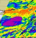
When NASA's Aqua satellite flew over Tropical Storm Conson on July 14 at 1747 UTC (1:47 p.m. EDT), the Atmospheric Infrared Sounder (AIRS) instrument captured a look at the storm's cloud-top temperatures. Cloud top temperatures tell scientists how high thunderstorms are and that translates into strength because the higher and colder the cloud tops, the stronger the thunderstorms, and typically more rain falls from them.
AIRS infrared measurements of Tropical Storm Conson's thunderstorm cloud-top temperatures revealed 2 large areas of strong convection and icy cold (high, strong thunderstorms) cloud tops that were colder than -63 Fahrenheit. That means there was a lot of energy in Tropical Storm Conson yesterday when the Aqua satellite passed overhead. Animated infrared satellite imagery today, July 15, showed tightly wrapped convective banding around the storm's center indicating its maintaining intensity.
On July 15 at 0600 UTC (4 a.m. EDT), Tropical Storm Conson's maximum sustained winds were near 50 knots (57 mph). Conson was located about 290 nautical miles east-southeast of Hainan Island near 16.6 North and 113.3 East. It was moving west near 12 knots (13 mph).
Tropical Storm Conson is in an area of strong northeasterly vertical wind shear, blowing at a speed greater than 30 knots (34 mph). Despite the strong wind shear, the storm is maintaining intensity. However, that wind shear is pushing the strongest convection southwest of Conson's center.
Meteorologists at the Joint Typhoon Warning Center are forecasting Conson to keep tracking westward and cross Hainan Island in the next 24-36 hours (mid-day Eastern Time on Friday, July 16). Thereafter, Conson is expected to make landfall in northern Vietnam and dissipate over the weekend.
Source: NASA/Goddard Space Flight Center
Articles on the same topic
- NASA's Aqua Satellite sees Tropical Storm Conson now in South China SeaWed, 14 Jul 2010, 19:24:18 UTC
- NASA's 3-D animation of Typhoon Conson's heavy rainfall and strong thunderstormsTue, 13 Jul 2010, 20:30:15 UTC
- Tropical Storm Conson sweeping through the Northern PhilippinesTue, 13 Jul 2010, 19:42:31 UTC
- Tropical Storm Conson forms in northwestern PacificMon, 12 Jul 2010, 21:36:08 UTC
Other sources
- High pressure forcing Tropical Storm Conson farther south to Hainan Islandfrom PhysorgThu, 15 Jul 2010, 20:21:50 UTC
- High pressure forcing Tropical Storm Conson farther south to Hainan Islandfrom Science BlogThu, 15 Jul 2010, 18:21:10 UTC
- NASA's Aqua Satellite sees Tropical Storm Conson now in South China Seafrom PhysorgWed, 14 Jul 2010, 21:21:25 UTC
- NASA’s Aqua Satellite sees Tropical Storm Conson now in South China Seafrom Science BlogWed, 14 Jul 2010, 20:28:12 UTC
- NASA's 3-D animation of Typhoon Conson's heavy rainfall and strong thunderstormsfrom Science DailyWed, 14 Jul 2010, 1:28:15 UTC
- Tropical Storm Conson sweeping through the Northern Philippinesfrom PhysorgTue, 13 Jul 2010, 21:21:28 UTC
- NASA’s 3-D animation of Typhoon Conson’s heavy rainfall and strong thunderstormsfrom Science BlogTue, 13 Jul 2010, 21:14:11 UTC
- NASA's 3-D animation of Typhoon Conson's heavy rainfall and strong thunderstorms (w/ Video)from PhysorgTue, 13 Jul 2010, 20:56:24 UTC
- Tropical Storm Conson sweeping through the Northern Philippinesfrom Science BlogTue, 13 Jul 2010, 20:07:14 UTC
- Tropical Storm Conson forms in northwestern Pacificfrom Science BlogMon, 12 Jul 2010, 22:21:08 UTC
- Tropical Storm Conson forms in northwestern Pacificfrom PhysorgMon, 12 Jul 2010, 21:35:14 UTC
