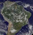
GOES-12 captures south Atlantic Tropical Storm 90Q far from Argentina's coast
The second–ever known tropical cyclone in the South Atlantic Ocean can't escape satellite eyes, and today, the Geostationary Operational Environmental Satellite, GOES-12 captured a visible image of Tropical Storm 90Q now located off the coast of Argentina. GOES-12 satellite captured an image of Tropical Storm 90Q at 1745 UTC (12:45 p.m. ET) today, March 12, when it was more than 1,350 miles east of Buenos Aires, Argentina, approximately near 36.5 degrees South latitude and 34.8 degrees West longitude. At 10 a.m. ET today, Tropical Storm 90Q still had maximum sustained winds near 46 mph (40 knots).
GOES-12 is operated by the National Oceanic and Atmospheric Administration, and images are created by NASA's GOES Project, located at NASA's Goddard Space Flight Center, Greenbelt, Md.
Tropical Storm 90Q is now moving quickly in a southeasterly direction and is starting to interact with a mid-latitude frontal system. By the end of the weekend, the Southern Atlantic Ocean's second tropical storm in recorded history is expected to be merged with a cold front and just remain in the history books.
Source: NASA/Goddard Space Flight Center
Articles on the same topic
- NASA's Aqua Satellite shows strong convection in Tropical Storm UluiFri, 12 Mar 2010, 21:30:22 UTC
- Tropical Storm Tomas approaching Nadi this weekendFri, 12 Mar 2010, 21:09:05 UTC
- Tropical Storm Tomas calls for alerts in south PacificThu, 11 Mar 2010, 23:22:27 UTC
- Second only south Atlantic tropical storm: 90Q, moving away from BrazilThu, 11 Mar 2010, 21:45:53 UTC
Other sources
- GOES-12 captures south Atlantic Tropical Storm 90Q far from Argentina's coastfrom PhysorgFri, 12 Mar 2010, 22:56:21 UTC
- GOES-12 captures south Atlantic Tropical Storm 90Q far from Argentina's coastfrom Science BlogFri, 12 Mar 2010, 22:22:06 UTC
- Tropical Storm Tomas approaching Nadi this weekendfrom Science BlogFri, 12 Mar 2010, 22:21:57 UTC
- Tropical Storm Tomas approaching Nadi this weekendfrom PhysorgFri, 12 Mar 2010, 22:14:37 UTC
- NASA's Aqua Satellite shows strong convection in Tropical Storm Uluifrom PhysorgFri, 12 Mar 2010, 21:49:32 UTC
- Second only south Atlantic tropical storm: 90Q, moving away from Brazilfrom PhysorgFri, 12 Mar 2010, 0:42:36 UTC
- Tropical Storm Tomas calls for alerts in south Pacificfrom PhysorgThu, 11 Mar 2010, 23:35:20 UTC
- Tropical Storm Tomas calls for alerts in south Pacificfrom Science BlogThu, 11 Mar 2010, 23:21:16 UTC
- Second Tropical Cyclone Ever Forms in South Atlanticfrom Live ScienceThu, 11 Mar 2010, 23:14:06 UTC
- Second only south Atlantic tropical storm: 90Q, moving away from Brazilfrom Science BlogThu, 11 Mar 2010, 22:14:13 UTC
- 90Q: A curious short-lived 'tropical' cyclone in the southern Atlanticfrom PhysorgWed, 10 Mar 2010, 22:35:55 UTC
- 90Q: A curious short-lived 'tropical' cyclone in the southern Atlanticfrom Science BlogWed, 10 Mar 2010, 21:35:23 UTC
