NASA data show Hurricane Frank's fluctuation in strength
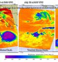
Infrared data from NASA's Aqua satellite showed a transition within Tropical Storm Frank over three days, and now Frank has become the Eastern Pacific's fifth hurricane. NASA's Aqua satellite passed over Frank on three days, July 24, 25 and 26 and gathered infrared temperature data on the storm using the Atmospheric Infrared Sounder instrument. During that three day period, Frank weakened on July 25 and infrared data showed cloud top temperatures warmed and thunderstorm activity decreased. Warming cloud tops means that the top of the clouds are not as high in the troposphere as they were before (the higher you go in the troposphere, the colder it is). Warming cloud tops indicate weaker uplift of air in the storm, making it weaker
Data showed that the area of coldest cloud top temperatures, in excess of minus 63 degrees Fahrenheit (minus 53 degrees Celsius) and strongest thunderstorms diminished on July 25 and expanded again on July 26 as Frank moved over warm waters. Forecaster Pasch of the National Hurricane Center (NHC) noted this morning, July 26 that "deep convection associated with Frank has recently increased."
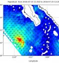
In addition to looking at temperatures, NASA's RapidScat looked at Frank's winds. The RapidScat instrument that flies aboard the International Space Station (ISS) has been analyzing the winds around Tropical Storm Frank. RapidScat is a scatterometer that can measure wind speeds over open ocean surfaces. The ISS passed over the eastern side of Tropical Storm Frank and RapidScat saw strongest winds near 27 meters per second (60.4 mph/97.2 kph) were occurring in the storm's northeastern quadrant. RapidScat found that tropical-storm-force winds extend outward up to 70 miles (110 km) from the center.
At 11 a.m. EDT (1500 UTC) on July 26, 2016 the eye of Hurricane Frank was located near latitude 21.2 degrees north and longitude 116.6 degrees west. Frank is moving toward the west-northwest at 9 mph (15 kph) and the NHC said this general motion is expected to continue for the next couple of days. Maximum sustained winds have increased to near 75 mph (120 kph) with higher gusts. Little change in strength is expected today.
NHC said that weakening is expected to begin on Wednesday as Frank moves into waters cooler than the 26.6 degree Celsius (80 degree Fahrenheit) threshold needed to maintain a tropical cyclone.
Source: NASA/Goddard Space Flight Center
Articles on the same topic
- Satellite tracks the remnants of Tropical Storm GeorgetteWed, 27 Jul 2016, 18:38:20 UTC
- NASA sees compact Tropical Storm Frank weakeningWed, 27 Jul 2016, 18:04:02 UTC
- Eastern Pacific storms Georgette and Frank see-saw in strengthTue, 26 Jul 2016, 18:06:02 UTC
- NASA spies major Hurricane GeorgetteTue, 26 Jul 2016, 18:05:37 UTC
- NASA scans Tropical Storm Frank's windsTue, 26 Jul 2016, 18:05:28 UTC
- NASA spots Tropical Storm Darby as warnings posted in HawaiiSun, 24 Jul 2016, 19:01:50 UTC
- NASA catches Estelle becoming post-tropicalFri, 22 Jul 2016, 19:23:39 UTC
- NASA's GPM observes newly formed Tropical Storm GeorgetteFri, 22 Jul 2016, 18:26:22 UTC
- NASA spots 'hot towers' in intensifying Tropical Storm FrankFri, 22 Jul 2016, 18:26:13 UTC
Other sources
- NASA sees compact Tropical Storm Frank weakeningfrom PhysorgWed, 27 Jul 2016, 20:41:19 UTC
- Satellite tracks the remnants of Tropical Storm Georgettefrom PhysorgWed, 27 Jul 2016, 20:11:16 UTC
- Eastern Pacific storms Georgette and Frank see-saw in strengthfrom PhysorgTue, 26 Jul 2016, 18:01:44 UTC
- NASA data show Hurricane Frank's fluctuation in strengthfrom PhysorgTue, 26 Jul 2016, 17:31:49 UTC
- NASA scans Tropical Storm Frank's windsfrom PhysorgMon, 25 Jul 2016, 20:31:20 UTC
- NASA spies major Hurricane Georgettefrom PhysorgMon, 25 Jul 2016, 20:01:10 UTC
- Tropical Storm Darby bearing down on Hawaiifrom UPISun, 24 Jul 2016, 1:01:11 UTC
- NASA catches Estelle becoming post-tropicalfrom PhysorgSat, 23 Jul 2016, 8:51:20 UTC
- NASA spots Tropical Storm Darby as warnings posted in Hawaiifrom PhysorgSat, 23 Jul 2016, 8:51:19 UTC
- NASA's GPM observes newly formed Tropical Storm Georgettefrom PhysorgFri, 22 Jul 2016, 18:21:41 UTC
- NASA Spots "Hot Towers" in Intensifying Tropical Storm Frankfrom PhysorgFri, 22 Jul 2016, 15:21:34 UTC
- GPM measured heavy rain in Tropical Storm Estellefrom PhysorgThu, 21 Jul 2016, 18:51:23 UTC

