Developing tropical storm triggers deadly landslides in Sri Lanka
Related images
(click to enlarge)
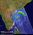
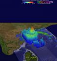
A storm does not have to be especially powerful in terms of its winds to be deadly. Such is the case with Tropical Cyclone 01B (TC 01B) in the Bay of Bengal. Despite only reaching minimal tropical storm intensity just this morning at 06 UTC 18 May 2016, the system has been responsible for dumping heavy rains in and around Sri Lanka and southern Indian over the past few days as it tried to organize itself in the southwestern Bay of Bengal. This set the stage for two massive landslides, which buried 3 villages in south central Sri Lanka. So far, although several hundred people have been rescued, it is feared from 150 to as many as 400 others may have been buried by the mudslides. The center of TC 01B itself is currently located well north of Sri Lanka just off the southeastern coast of India. GPM captured these images of Tropical Cyclone 01B at 02:38 UTC 18 May 2016 as the center was spinning just off the Indian coastline.
The first image (to the right) shows rain rates derived from the GPM GMI (outer swath) and DPR (inner swath). The image reveals that TC 01B is still in the process of getting organized. The rain field is still rather asymmetric with a single large rain band north of the system (show in green and red, indicating moderate to heavy rain) that wraps around west of the center. However, there is a very intense area of rain (shown in pink) located just west of the center within the storm's core.
The second image (below) shows that this area of intense rain is associated with a deep convective tower reaching heights of over 18 km (11.2 miles) and indicates where large amounts of heat are being released into the storm's core. This can often be a pre-cursor to intensification.
However, TC 01B's close proximity to the southeast coast of Indian can also inhibit strengthening. TC 01B is forecast to slowly strengthen into a stronger tropical storm while paralleling the east of coast India as it heads towards the northern Bay of Bengal.
GPM is a joint missions between NASA and the Japanese space agency JAXA.
Source: NASA/Goddard Space Flight Center
Articles on the same topic
- Tropical Cyclone 01B named Roanu and is strengtheningSat, 21 May 2016, 16:31:51 UTC
Other sources
- At least 15 killed as cyclone Roanu hits coast of Bangladeshfrom UPISat, 21 May 2016, 16:30:53 UTC
- Tropical Cyclone 01B named Roanu and is strengtheningfrom PhysorgThu, 19 May 2016, 17:51:17 UTC
- Developing tropical storm triggers deadly landslides in Sri Lankafrom PhysorgThu, 19 May 2016, 13:21:09 UTC

