Fort McMurray fire continues in Alberta
Related images
(click to enlarge)

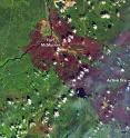
On May 12, 2016, a total of 17 wildfires were still burning in the vicinity of Fort McMurray, Canada. Provincial authorities still considered one of those fires to be "out of control." As of May 12, fires in that part of Alberta had burned up at least 2,410 square kilometers (930 square miles) of land. The Operational Land Imager (OLI) on the Landsat 8 satellite acquired this image of the burn scar on May 12. The false-color image combines shortwave infrared, near infrared, and green light (OLI bands 7-5-3). Near- and short-wave infrared help penetrate clouds and smoke (white) to reveal the hot spots associated with active fires (red). With this combination, burned areas appear brown.
References for the image and caption above: Alberta Government (2016, May 12) Wildfire Update 13: May 12 at 1:30 p.m. Accessed May 16, 2016.
NASA Earth Observatory image by Joshua Stevens, using Landsat data from the U.S. Geological Survey. Caption by Kathryn Hansen.
Instrument(s): Landsat 8 - OLI
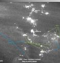
In addition, the Suomi NPP satellite took this image of the Fort McMurray fires and nearby area with the VIIRS instrument in the early morning hours of May 15, 2016. The image shows both the fire and the smoke in contrast.
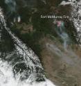
On May 15, 2016, the Suomi NPP satellite took a daytime image of the Fort McMurray fire in Alberta, Canada and provided this image.
On May 16, 2016, the Alberta, Canada government site reported that fire conditions remain extreme in the province with the Fort McMurray wildfire still out of control. The fire is estimated to cover 284,214 hectares (1,097 square miles) and four new fires started over the past 24 hours. A total of 15 wildfires are burning, with three out of control. There are 1,919 firefighters, 161 helicopters, 377 pieces of heavy equipment and 29 air tankers currently battling the fires. Fort McMurray, Anzac, Gregoire Lake Estates and Fort McMurray First Nation remain under a mandatory evacuation order.
NASA image courtesy Jeff Schmaltz LANCE/EOSDIS MODIS Rapid Response Team, GSFC. Caption by Lynn Jenner with information from the Alberta Canada government site.
Source: NASA/Goddard Space Flight Center
Other sources
- NASA satellites image Fort McMurray fires day and nightfrom PhysorgThu, 19 May 2016, 11:51:10 UTC
- Fort McMurray residents eye resettlement plans after devastating wildfirefrom UPIThu, 19 May 2016, 11:10:51 UTC
- Fires evolve to threaten Alberta oil sandsfrom UPITue, 17 May 2016, 13:31:09 UTC
- Canadian oil services start to returnfrom UPIMon, 16 May 2016, 14:00:57 UTC
- Canadian Prime Minister Justin Trudeau visits aftermath of destructive wildfiresfrom UPISat, 14 May 2016, 16:30:47 UTC

