NASA sees formation of unusual North Atlantic Hurricane Alex
Related images
(click to enlarge)
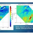
The low pressure area known as System 90L developed rapidly since Jan. 13 and became Hurricane Alex on Jan. 14. Several satellites and instruments captured data on this out-of-season storm. NASA's RapidScat instrument observed sustained winds shift and intensify in the system and NASA's Aqua satellite saw the storm develop from a low pressure area into a sub-tropical storm. NOAA's GOES-East satellite data was made into an animation that showed the development of the unusual storm. Twice on Jan. 13 NASA's RapidScat instrument measured the strongest sustained winds in what was then a tropical low pressure area called "System 90L." RapidScat flies aboard the International Space Station. RapidScat's earliest view of System 90L showed strongest sustained winds were near 27 meters per second (mps)/60.4 mph/97.2 kph) and were located northwest of center. Eight hours later at 1200 UTC (7 a.m. EST) strongest sustained winds shifted east of center and increased to near 30 mps (67.1 mph/108 kph), making them tropical-storm force.
Later in the day at 2100 UTC (4 p.m. EST) satellite images indicated that the low pressure system developed into a subtropical storm and was named Alex. At the time, Alex was located near 27.1 degrees north latitude and 30.8 degrees west longitude, about 782 miles (1,260 km) south-southwest of the Azores.
By 1500 UTC (10 a.m. EST) on January 14, hurricane force winds extended outward up to 25 miles (35 km) from the center and tropical storm force winds extend outward up to 150 miles (240 km).
An animation of GOES-East satellite visible and infrared imagery from Jan. 10 to 14 showed the development of Hurricane Alex in the Central Pacific Ocean. The animation was created at the NASA/NOAA GOES Project at NASA's Goddard Space Flight Center in Greenbelt, Maryland. The animation showed the sub-tropical low pressure area consolidate quickly on Jan. 13 and reach hurricane status on Jan. 14, 2016.
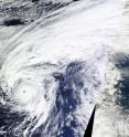
The Moderate Resolution Imaging Spectroradiometer or MODIS instrument that flies aboard NASA's Aqua satellite captured a visible image of Hurricane Alex on Jan. 14 at 15:30 UTC (10:30 a.m. EST) in the central Atlantic Ocean. The image revealed an eye and showed bands of thunderstorms spiraling into the low level center of circulation.
According to the National Hurricane Center, Alex is the first hurricane to form in the month of January since 1938. Alex is also the first North Atlantic hurricane thriving in January since Alice of 1955, which formed on Dec. 30, 1954. Alice developed on December 30, 1954 from a trough of low pressure in the central Atlantic Ocean in an area of unusually favorable conditions.
The Azores Meteorological Service has issued a Hurricane Warning for the islands of Faial, Pico, Sao Jorge, Graciosa, and Terceira in the central Azores, and a Tropical Storm Warning for the islands of Sao Miguel and Santa Maria in the eastern Azores. A Hurricane Warning is in effect for Faial, Pico, Sao Jorge, Graciosa, and Terceira in the central Azores and a Tropical Storm Warning is in effect for Sao Miguel and Santa Maria in the eastern Azores.
At 10 a.m. EST (1500 UTC), the National Hurricane Center said that the center of Hurricane Alex was located near latitude 31.5 North, longitude 28.4 West. Alex was moving toward the north-northeast near 20 mph (31 kph) and a turn toward the north with an increase in forward speed is expected over the next day or two. On the forecast track, the center of Alex will move near or over portions of the Azores Friday morning, Jan. 15.
Maximum sustained winds are near 85 mph (140 kph) with higher gusts. Little change in strength is forecast through Friday. The estimated minimum central pressure is 981 millibars.
NHC's Forecaster Pasch said "Remarkably, Alex has undergone the transformation into a hurricane. A distinct eye is present, embedded within a fairly symmetric mass of deep convection. It is very unusual to have a hurricane over waters that are near 20 degrees Celsius, but the upper-tropospheric temperatures are estimated to be around -60 degrees Celsius, which is significantly colder than the tropical mean. The resulting instability is likely the main factor contributing to the tropical transition and intensification of Alex."
Alex is expected to maintain hurricane status on Friday, Jan. 15 and transition into an extra-tropical storm by Jan. 16 as it continues to move north toward Greenland.
Source: NASA/Goddard Space Flight Center
Articles on the same topic
- NASA provides in-depth analysis of unusual Tropical Storm AlexFri, 15 Jan 2016, 21:10:37 UTC
Other sources
- NASA provides in-depth analysis of unusual Tropical Storm Alexfrom PhysorgFri, 15 Jan 2016, 20:51:24 UTC
- NASA sees formation of unusual North Atlantic Hurricane Alexfrom Science DailyFri, 15 Jan 2016, 9:03:11 UTC
- NASA sees formation of unusual North Atlantic Hurricane Alexfrom PhysorgThu, 14 Jan 2016, 20:04:18 UTC
- NASA analyzes winds and rainfall in unusual Atlantic system 90Lfrom PhysorgWed, 13 Jan 2016, 19:52:41 UTC

