NASA sees Ula go extra-tropical
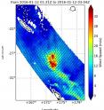
West satellite and NASA's RapidScat instrument provided a look at Tropical Cyclone Ula after it became extra-tropical north of New Zealand. On Jan. 12, RapidScat, instrument that flies aboard the International Space Station, saw Extra-tropical Storm Ula's strongest winds (red) east to south of the center at 32 meters per second (71.5 mph/ 115.2 kph). Maximum sustained winds are not always equally distributed in a tropical cyclone and the RapidScat instrument helps forecasters find the strongest quadrants of a storm.
Ula ran into increasing vertical wind shear that continued weakening the storm, and pushing its clouds and showers southeast of the center.
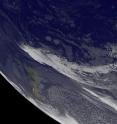
NOAA's GOES-West satellite captured an infrared view of extra-tropical Storm Ula north of New Zealand on Jan. 13 at 1500 UTC (11 a.m. EST). The image showed the bulk of clouds associated with the storm were pushed to the southeast of the center as a result of strong vertical wind shear. The image was created by the NASA/NOAA GOES Project at NASA's Goddard Space Flight Center, Greenbelt, Maryland.
At 0000 UTC on Jan. 13 (7 p.m. EST, Jan. 12) Extra-tropical Cyclone Ula ULA (1001hPa) was located over sub-tropical waters near 29.8 south latitude and 175.7 east longitude. Ula was moving south-southeast at 10 knots (11.5 mph/18.5 kph) away from the tropics. Ula is expected to dissipate in a couple of days.
For updated forecasts, visit the New Zealand Meteorological Service at: http://www.metservice.com/national/home.
Source: NASA/Goddard Space Flight Center
Articles on the same topic
- NASA analyzes winds and rainfall in unusual Atlantic system 90LWed, 13 Jan 2016, 19:44:39 UTC
- NASA and NOAA satellite data see North Atlantic system more concentratedWed, 13 Jan 2016, 19:44:04 UTC
- Tropical Cyclone Ula's winds, rainfall seen by NASA's GPM and RapidScatTue, 12 Jan 2016, 17:23:05 UTC
- NASA sees Tropical Cyclone Ula's eye closingMon, 11 Jan 2016, 17:51:10 UTC
- NASA sees stubborn Tropical Cyclone Ula kick upFri, 8 Jan 2016, 17:55:48 UTC
- NASA analyzes Tropical Storm Ula's windsThu, 7 Jan 2016, 18:32:30 UTC
- NASA sees Tropical Cyclone Ula weakeningWed, 6 Jan 2016, 17:21:29 UTC
- Tropical Storm Ula weakens, moves southTue, 5 Jan 2016, 19:20:20 UTC
- NASA-NOAA's Suomi NPP satellite sees Ula moving away from FijiTue, 5 Jan 2016, 19:20:03 UTC
Other sources
- NASA sees Ula go extra-tropicalfrom PhysorgWed, 13 Jan 2016, 18:33:04 UTC
- NASA and NOAA satellite data see North Atlantic system more concentratedfrom PhysorgTue, 12 Jan 2016, 20:37:23 UTC
- Tropical Cyclone Ula's winds, rainfall seen by NASA's GPM and RapidScatfrom PhysorgTue, 12 Jan 2016, 18:59:48 UTC
- NASA sees Tropical Cyclone Ula's eye closingfrom PhysorgMon, 11 Jan 2016, 17:41:26 UTC
- NASA sees stubborn Tropical Cyclone Ula kick upfrom PhysorgFri, 8 Jan 2016, 19:44:22 UTC
- NASA analyzes Tropical Storm Ula's windsfrom PhysorgFri, 8 Jan 2016, 0:05:24 UTC
- NASA sees Tropical Cyclone Ula weakeningfrom PhysorgWed, 6 Jan 2016, 16:50:37 UTC
- Tropical Storm Ula weakens, moves southfrom PhysorgTue, 5 Jan 2016, 19:16:01 UTC
- NASA-NOAA's Suomi NPP satellite sees Ula moving away from Fijifrom PhysorgMon, 4 Jan 2016, 17:05:34 UTC
- NASA sees Tropical Cyclone Ula's eye and rainfallfrom PhysorgFri, 1 Jan 2016, 17:02:13 UTC

