NASA and NOAA satellite data see North Atlantic system more concentrated
NASA and NOAA satellites continue to monitor the North Atlantic Ocean's non-tropical low pressure system for hints of development into a subtropical storm. NASA's Aqua satellite provided cloud top temperatures that show where strongest storms are within the larger system, and the storm appeared more consolidated on NOAA's GOES-East satellite imagery. NOAA's National Hurricane Center (NHC) noted the development of the extra-tropical low pressure area on Sunday, January 10 at 1:50 p.m. EST.
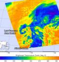
The Atmospheric Infrared Sounder known as the AIRS instrument aboard NASA's Aqua satellite measured temperatures in the system's cloud tops on Jan. 11 at 0435 (Jan. 10 at 11:35 p.m. EST) and later at 1541 UTC (10:41 a.m. EST). AIRS provides valuable temperature data such as cloud top and sea surface temperatures. AIRS saw the coldest cloud top temperatures near -63F/-53C and strongest storms expanded from east of center to around the center of this out-of-season extra-tropical low pressure area.
NOAA's GOES-East satellite captured a visible image of the low pressure area on Jan. 12 at 1445 UTC (9:45 a.m.) EST. Clouds and storms surrounded the center of circulation and in a band east of the center. The low pressure area has been designated "System 90L."
On Jan. 12 at 2 p.m. EST, the low was centered 1,100 miles southwest of the Azores, an archipelago in the mid-Atlantic. The National Hurricane Center noted that cloudiness and thunderstorms have become a little more concentrated and organized near the center of the storm's circulation. The low was producing winds to near 60 mph over the southern and eastern quadrants of its circulation. The cyclone is expected to move eastward to northeastward over the eastern subtropical Atlantic over the next couple of days.
NHC said "Although environmental conditions are only marginally conducive for development, this system could become a subtropical or tropical storm within the next day or so. Regardless of subtropical or tropical cyclone formation, this system is expected to produce hazardous marine conditions over portions of the eastern Atlantic for the next few days."
The National Hurricane Center gives this system a medium chance to develop into a depression over the next five days.
For updated forecasts, visit NHC at http://www.nhc.noaa.gov or the National Weather Service High Seas Forecast at http://www.opc.ncep.noaa.gov/shtml/NFDHSFAT1.shtml.
Source: NASA/Goddard Space Flight Center
Articles on the same topic
- NASA analyzes winds and rainfall in unusual Atlantic system 90LWed, 13 Jan 2016, 19:44:39 UTC
- NASA sees Ula go extra-tropicalWed, 13 Jan 2016, 19:44:22 UTC
- Tropical Cyclone Ula's winds, rainfall seen by NASA's GPM and RapidScatTue, 12 Jan 2016, 17:23:05 UTC
- NASA sees Tropical Cyclone Ula's eye closingMon, 11 Jan 2016, 17:51:10 UTC
- NASA sees stubborn Tropical Cyclone Ula kick upFri, 8 Jan 2016, 17:55:48 UTC
- NASA analyzes Tropical Storm Ula's windsThu, 7 Jan 2016, 18:32:30 UTC
- NASA sees Tropical Cyclone Ula weakeningWed, 6 Jan 2016, 17:21:29 UTC
- Tropical Storm Ula weakens, moves southTue, 5 Jan 2016, 19:20:20 UTC
- NASA-NOAA's Suomi NPP satellite sees Ula moving away from FijiTue, 5 Jan 2016, 19:20:03 UTC
Other sources
- NASA sees Ula go extra-tropicalfrom PhysorgWed, 13 Jan 2016, 18:33:04 UTC
- NASA and NOAA satellite data see North Atlantic system more concentratedfrom PhysorgTue, 12 Jan 2016, 20:37:23 UTC
- Tropical Cyclone Ula's winds, rainfall seen by NASA's GPM and RapidScatfrom PhysorgTue, 12 Jan 2016, 18:59:48 UTC
- NASA sees Tropical Cyclone Ula's eye closingfrom PhysorgMon, 11 Jan 2016, 17:41:26 UTC
- NASA sees stubborn Tropical Cyclone Ula kick upfrom PhysorgFri, 8 Jan 2016, 19:44:22 UTC
- NASA analyzes Tropical Storm Ula's windsfrom PhysorgFri, 8 Jan 2016, 0:05:24 UTC
- NASA sees Tropical Cyclone Ula weakeningfrom PhysorgWed, 6 Jan 2016, 16:50:37 UTC
- Tropical Storm Ula weakens, moves southfrom PhysorgTue, 5 Jan 2016, 19:16:01 UTC
- NASA-NOAA's Suomi NPP satellite sees Ula moving away from Fijifrom PhysorgMon, 4 Jan 2016, 17:05:34 UTC
- NASA sees Tropical Cyclone Ula's eye and rainfallfrom PhysorgFri, 1 Jan 2016, 17:02:13 UTC

