Wrangling data flood to manage the health of streams
Related images
(click to enlarge)
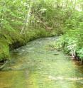
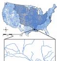
Today's natural resource manager tending to the health of a stream in Louisiana needs to look upstream. Way upstream -- like Montana. Michigan State University (MSU) scientists have invented a way to more easily manage the extensive nature of streams. There are 2.6 million stream reaches in the contiguous United States that are intricately interconnected. It's impossible to address the health of one reach without knowing what's happening upstream.
Science, wielding geographic information systems, has obliged with data on geology, climate, pollution and land use. But with that wealth of information comes a crushing amount of data files, making analysis slow and cumbersome.
In the current open-access edition of Springer Plus, Yin-Phan Tsang, a research assistant in MSU's Center for Systems Integration and Sustainability (CSIS), and her team present a new database and algorithm that allows other researchers and conservation managers to understand what's coming downstream without being weighted down by data files.
"Before, we needed a week to do an analysis on one parameter of land use in stream catchments," Tsang said. "Now, we can run 24 parameters for every one of the 2.6 million streams in five hours."
The algorithm script, included in the paper, can tackle entire countries, but also works with any database to characterize landscape factors in smaller areas. It just needs the regions in question to have its streams broken down into small "discrete" units assigned a unique identifier and an identifier that shows its upstream connectors.
Members of the aquatic landscape ecology lab and CSIS, parts of the Department of Fisheries and Wildlife, spend their time working to understand how landscape factors like agriculture and urban land use influence the physical characteristics like rivers and streams.
The paper, "An approach for aggregating upstream catchment information to support research and management of fluvial systems across large landscapes," was written by Tsang, Daniel Wieferich and associate professor Dana Infante from MSU, Kuolin Fung of 2DiiKaTwenty9 in East Lansing and Arthur Cooper of the Department of Natural Resources, Institute for Fisheries Research in Ann Arbor.
"We had been really struggling with one parameter at a time," Tsang said. "We are tired of it and we knew there was a better way to do this.."
Source: Michigan State University
Other sources
- Wrangling data flood to manage health of streamsfrom Science DailyTue, 4 Nov 2014, 9:02:37 UTC
- Wrangling data flood to manage the health of streamsfrom PhysorgMon, 3 Nov 2014, 15:00:58 UTC

