NASA sees birth of first Southern Indian Ocean season tropical storm
The Southern Indian Ocean cyclone season is off and running and NASA's Aqua satellite saw the birth of Tropical Cyclone 01S. Tropical Cyclone 01S (TC01S) formed Dec. 5, 2011. TC01S has maximum sustained winds near 55 knots (63 mph/102 kmh) and is rapidly consolidating and organizing, so strengthening is forecast. At 0900 UTC (4 a.m. EST) on Dec. 5, TC01S was located about 545 nautical miles west of the Cocos Islands near 12.2 South and 87.0 East. It was moving to the west at 7 knots 8 mph/13 kmh).
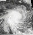
The Moderate Resolution Imaging Spectroradiometer (MODIS) instrument on NASA's Aqua satellite captured an image of Tropical Cyclone 01S on Dec. 5 at 08:18 UTC (3:18 a.m. EST) in the Southern Indian Ocean. Strong thunderstorms are visible around the center as they cast shadows on the lower surrounding clouds.
Microwave satellite instruments showed an eye developing in TC01S. There is also tightly curved banding of thunderstorms around the low-level center. T01S has intensified rapidly over the first 12 hours of its existence. The Joint Typhoon Warning Center forecasters expect TC01S to strengthen to hurricane-force over the next two days and track to the southeast, staying at sea.
Source: NASA/Goddard Space Flight Center
Other sources
- NASA sees Alenga become a cyclone in the Southern Indian Oceanfrom PhysorgThu, 8 Dec 2011, 22:00:40 UTC
- NASA sees Tropical Storm Alenga intensifyingfrom PhysorgWed, 7 Dec 2011, 21:31:08 UTC
- NASA's TRMM satellite sees the power in Tropical Storm Alengafrom Science DailyWed, 7 Dec 2011, 6:40:30 UTC
- NASA's TRMM satellite sees the power in Tropical Storm Alengafrom PhysorgTue, 6 Dec 2011, 22:31:03 UTC
- NASA sees birth of first Southern Indian Ocean season tropical stormfrom Science DailyTue, 6 Dec 2011, 0:50:54 UTC
- NASA sees birth of first Southern Indian Ocean season tropical stormfrom PhysorgMon, 5 Dec 2011, 22:21:43 UTC
