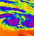
NASA Satellite sees two 'tropical fists' threatening Australia
Australia is getting hit with two "tropical fists" as NASA satellites watch two low pressure areas develop near the Northern Territory and Western Australia. System 99S is currently strengthening near Darwin, Australia and another low pressure area called System 97S is strengthening near Western Australia. System 97S was located about 210 nautical miles north-northwest of Learmonth, Western Australia, at 1800 UTC (1 p.m. EST), Feb. 15. It was centered near 19.2 South and 112.1 East. That puts the center of System 97S well to the northwest of Exmouth. System 97S is forecast to move west or southwest over the next few days.
NASA's Atmospheric Infrared Sounder (AIRS) instrument captured infrared satellite data of System 97S on Feb. 15 at 06:17 UTC (1:17 a.m. EST). AIRS flies onboard NASA's Aqua satellite and the data showed three areas of strong convection in the low pressure area. Those areas of convection appear to be consolidating. Water vapor imagery confirmed that System 97S has rapidly consolidated in the 12 hours before and showed banding of thunderstorms around the southern edge of the center of circulation.
Maximum sustained winds are estimated between 20-25 knots (23 to 29 mph/37 to 46 kmh) and minimum sea level pressure at 1003 millibars.
A Cyclone Watch has been declared for coastal areas from Onslow to Coral Bay. Strong Wind Warnings are in effect from Wallal to Barrow Island, Barrow Island to Northwest Cape, and Northwest Cape to Coral Bay.
The Joint Typhoon Warning Center gives System 97S a good chance of becoming a tropical depression in the next 24 hours. Forecasts currently keep System 97S away from land over the next three days.
Source: NASA/Goddard Space Flight Center
Articles on the same topic
- NASA sees former Tropical Storm Carlos still a soaker in the Northern TerritoryThu, 17 Feb 2011, 22:03:15 UTC
- NASA infrared satellite data see an intensifying Tropical Storm DianneThu, 17 Feb 2011, 22:03:14 UTC
- NASA sees tropical cyclone double-trouble for AustraliaWed, 16 Feb 2011, 19:37:20 UTC
- NASA Satellite catches a tropical cyclone forming near Darwin, AustraliaTue, 15 Feb 2011, 22:33:12 UTC
Other sources
- NASA infrared satellite data see an intensifying Tropical Storm Diannefrom Science BlogThu, 17 Feb 2011, 23:50:11 UTC
- NASA infrared satellite data see an intensifying Tropical Storm Diannefrom PhysorgThu, 17 Feb 2011, 23:20:33 UTC
- NASA sees former Tropical Storm Carlos still a soaker in the Northern Territoryfrom PhysorgThu, 17 Feb 2011, 23:20:31 UTC
- NASA sees former Tropical Storm Carlos still a soaker in the Northern Territoryfrom Science BlogThu, 17 Feb 2011, 22:20:13 UTC
- NASA sees tropical cyclone double-trouble for Australiafrom Science BlogWed, 16 Feb 2011, 20:30:45 UTC
- NASA sees tropical cyclone double-trouble for Australiafrom PhysorgWed, 16 Feb 2011, 20:00:16 UTC
- Aqua satellite catches a tropical cyclone forming near Darwin, Australiafrom PhysorgTue, 15 Feb 2011, 23:30:37 UTC
- NASA Satellite catches a tropical cyclone forming near Darwin, Australiafrom Science BlogTue, 15 Feb 2011, 23:30:34 UTC
- NASA Satellite sees two ‘tropical fists’ threatening Australiafrom Science BlogTue, 15 Feb 2011, 23:30:28 UTC
- NASA satellite sees two 'tropical fists' threatening Australiafrom PhysorgTue, 15 Feb 2011, 22:30:32 UTC
