NASA watching Jal's remnants in the Arabian Sea for possible rebirth
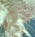
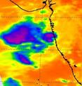
Infrared and visible imagery from NASA's Aqua satellite today hinted that the low pressure area formerly known as Cyclone Jal may have new life soon. Jal has emerged into the warm waters of the Arabian Sea after crossing India this past weekend. The Atmospheric Infrared Sounder (AIRS) instrument that flies onboard Aqua captured infrared and visible images of Jal's remnants on Nov. 9 at 1:30 p.m. local time/India.
Today's AIRS imagery hints that circulation is still occurring in Jal's remnants. The circulation was particularly apparent in the AIRS visible image. The AIRS infrared satellite image showed that the strongest convection and thunderstorms are now occurring to the west of the center of circulation and over the open waters of the Arabian Sea.
At 900 GMT (4 a.m. EST) on Nov. 9, the remnants of Tropical Cyclone Jal was over the waters of the eastern Arabian Sea. The Arabian Sea is located in the northwestern part of the Indian Ocean and covers a total area of about 1,491,000 square miles.
Relative to land and the nearest city in India, Jal's remnant low was about 70 miles east-southeast of Mumbai near 17.4 North and 71.9 East. Mumbai is the capital of the Indian state of Maharashtra and is located on India's west coast. It is the most populous city in India with 14 million residents.
The forecasters at the Joint Typhoon Warning Center are monitoring Jal's remnants for possible regeneration later today.
Source: NASA/Goddard Space Flight Center
Other sources
- NASA watching Jal's remnants in the Arabian Sea for possible rebirthfrom PhysorgTue, 9 Nov 2010, 19:01:16 UTC
- NASA watching Jal’s remnants in the Arabian Sea for possible rebirthfrom Science BlogTue, 9 Nov 2010, 18:32:46 UTC
- NASA sees Tropical Depression Jal's remnants entering and leaving Indiafrom PhysorgMon, 8 Nov 2010, 18:30:49 UTC
- NASA sees Tropical Depression Jal’s remnants entering and leaving Indiafrom Science BlogMon, 8 Nov 2010, 18:10:12 UTC

