NASA captures very heavy rain in Typhoon Fanapi and 2 landfalls
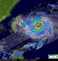
Taiwan experienced a landfall and a soaking from Typhoon Fanapi, and NASA and JAXA's TRMM satellite noted a large area of very heavy rain in the system before it made landfall this weekend. NASA's Aqua and Terra satellites also captured impressive visible images of Fanapi just before the Taiwan landfall, and as it was making landfall in eastern China very early today. The Tropical Rainfall Measuring Mission satellite known as TRMM captured an image of Typhoon Fanapi's rainfall on Sept. 18 at 0653 UTC (2:53 a.m. EDT) after the typhoon had intensified to 105 knots (~121 mph). TRMM rainfall data showed heavy rain, falling at a rate greater than 2 inches per hour, circling the Fanapi's eye, except in the north of the circulation. Most rainfall outside of the center was falling moderately.
The Moderate Resolution Imaging Spectroradiometer (MODIS) instrument flies on both NASA's Aqua and Terra satellites and provides high resolution images of tropical cyclones, fires, ice and various other areas on Earth. This past weekend, both satellites were flying over the Pacific Northwest Ocean where Typhoon Fanapi was making landfall twice, in Taiwan and China.
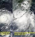
On Sept. 18 at 220 UTC NASA's Terra satellite captured Typhoon Fanapi approaching Taiwan. Two days later, today, Sept. 20, the MODIS instrument on NASA's Aqua satellite captured Typhoon Fanapi making landfall in China at 05:15 UTC (1:15 a.m. EDT).
Just before Fanapi made landfall, NASA's Aqua satellite captured an infrared look at the cold cloud tops of the storm. The infrared image of Typhoon Fanapi from the Atmospheric Infrared Sounder (AIRS) instrument aboard Aqua showed that the strongest convection, strongest thunderstorms and heaviest rainfall on Sept. 20 at 05:11 UTC (1:11 a.m. EDT) were still over the South China Sea and had not yet moved inland. Since that time, the heavy rainfall has moved inland.
After Typhoon Fanapi made landfall earlier today it weakened quickly. By 0900 UTC (5 a.m. EDT) Fanapi had already weakened to a tropical storm with maximum sustained winds near 56 mph. Fanapi made landfall more than 100 miles north of Hong Kong and continues to move inland in a westerly direction. The Joint Typhoon Warning Center placed the storm's center about 125 miles northeast of Hong Kong near 23.8 North latitude and 115.2 East longitude. Fanapi is expected to dissipate sometime on Tuesday, Sept. 21.
Source: NASA/Goddard Space Flight Center
Articles on the same topic
- NASA eyes Typhoon Fanapi approaching Taiwan14 years ago
Other sources
- NASA captures very heavy rain in Typhoon Fanapi and 2 landfallsfrom Science Blog14 years ago
- NASA eyes Typhoon Fanapi approaching Taiwanfrom Physorg14 years ago
- NASA eyes Typhoon Fanapi approaching Taiwanfrom Science Blog14 years ago
- NASA eyes Typhoon Fanapi approaching Taiwanfrom Science Blog14 years ago


