Like the writer, Agatha was a brief mystery
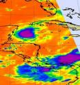
Tropical Storm Agatha made landfall this weekend in El Salvador and Guatemala, and crossed into the western Caribbean. Like Agatha Christie, the famous mystery writer, Agatha was somewhat of a forecasting mystery until today. NASA's infrared satellite data showed a strong area of thunderstorms in the middle of Agatha's remnants on June 1, but they have continued to erode and today, June 2, the mystery of possible regeneration has been solved as the National Hurricane Center gives the chance of reorganization "near zero percent."
Agatha's remnants swept into the Western Caribbean Sea and is now numbered "System 91L." At 1800 UTC (12 p.m. EDT) on June 1, the center was located east of the Yucatan Peninsula, Mexico, near 19.1 North and 85.9 West.
On Wednesday, June 2 at 1231 UTC (8:31 a.m. EDT) satellite imagery from the Geostationary Operational Environmental Satellite called GOES-13 showed three areas of concentrated scattered clouds in the Caribbean. One concentrated area of cloudiness was near northwestern Cuba, a larger area of cloudiness southeast of Florida, and in the Gulf of Mexico, one area of clouds south of Louisiana. None of these areas showed any signs of development.
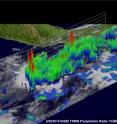
Looking back at May 28, when Tropical Storm Agatha was about to make landfall, NASA and the Japanese Space Agency's Tropical Rainfall Measuring Mission satellite captured rainfall rates and cloud heights of the storm. That data revealed hot towers (very strong thunderstorms around the center of circulation), higher than 16 kilometers (10 miles) with very heavy rainfall (more than 2 inches per hour) in red areas as it was making landfall.
Agatha's remnants, or the area that is now called "91L" in the Caribbean Sea doesn't appear have much of a chance of powering up to the kind of storm it was in the Eastern Pacific, and it is not a mystery anymore.
Source: NASA/Goddard Space Flight Center
Articles on the same topic
- Agatha drenches Guatemala and El Salvador, remnants now in CaribbeanTue, 1 Jun 2010, 21:52:03 UTC

