Super Typhoon Nida to pass east of Iwo To and Chichi Jima
Nida is still holding on to Super Typhoon status in the Western Pacific Ocean, and over the weekend, is forecast to pass east of both Iwo To and Chichi Jima islands. Although the center of Nida will remain at sea, both islands will face heavy surf, gusty winds and heavy rainfall. On Friday, November 27, at 0900 UTC (4 a.m. ET or 6 p.m. local Asia/Toyko time) Nida had maximum sustained winds near 149 mph (130 knots) with gusts to 184 mph (160 knots)! That makes Nida a Category 4 Typhoon. The range of sustained winds for a Category 4 typhoon (or hurricane) range from 131 to 155 mph (114-135 knots or 210-249 kilometers/hour).The National Hurricane Center says of a Category 4 Typhoon/hurricane: "Extremely dangerous winds causing devastating damage are expected."
Nida is about 300 miles in diameter, so tropical storm force winds extend as far as 150 miles from the center of the storm. Typhoon/hurricane-force winds extend 70 miles from Nida's center. Nida's eye is estimated to be about 25 nautical miles in diameter. Nida's center was located 415 nautical miles northwest of Guam, near 17.8 degrees North latitude and 139.2 degrees East longitude. Nida was moving north near 10 mph.
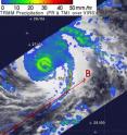
NASA and the Japanese Space Agency's Tropical Rainfall Measuring Mission (TRMM) satellite flew over the center of Super Typhoon Nida on November 26 and captured moderate rainfall around the storm's center between 20 and 40 millimeters (.78 to 1.57 inches) per hour, with some heavy rainfall, as much as 2 inches of rain per hour, in a rain band southeast of the storm's center.
The Joint Typhoon Warning Center noted that "Animated multispectral imagery shows a well-defined eye that is beginning to fill and become ragged. The same animation shows elongation on the northeast quadrant." Both of those factors indicate that the storm's strength is waning.
Nida was generating dangerously high waves, up to 39 feet high. As its center sweeps past Iwo To and Chichi Jima this weekend, those islands can expect very high surf with dangerous battering waves.
Nida is moving north, but will start heading northeast in the next day or two. It will also transition into an extra-tropical storm and continue weakening on its northern journey into cooler waters and areas of stronger wind shear.
Source: NASA/Goddard Space Flight Center
Articles on the same topic
- NASA's Terra and Aqua satellites see Nida fading, and 97W getting organizedThu, 3 Dec 2009, 18:19:37 UTC
- Nida getting knocked by winds, and 97W piquing interestWed, 2 Dec 2009, 21:47:00 UTC
- Typhoon Nida's cloud tops dropping as it zigzags in wind shearTue, 1 Dec 2009, 17:29:32 UTC
- NASA captures Typhoon Nida's clouds from 2 anglesMon, 30 Nov 2009, 21:07:53 UTC
Other sources
- NASA's Terra and Aqua satellites see Nida fading, and 97W getting organizedfrom PhysorgThu, 3 Dec 2009, 19:49:18 UTC
- NASA's Terra and Aqua satellites see Nida fading, and 97W getting organizedfrom Science BlogThu, 3 Dec 2009, 19:22:01 UTC
- Nida getting knocked by winds, and 97W piquing interestfrom Science BlogThu, 3 Dec 2009, 5:21:30 UTC
- Nida getting knocked by winds, and 97W piquing interestfrom Science BlogWed, 2 Dec 2009, 23:14:38 UTC
- Nida getting knocked by winds, and 97W piquing interestfrom PhysorgWed, 2 Dec 2009, 22:28:20 UTC
- Typhoon Nida's cloud tops dropping as it zigzags in wind shearfrom PhysorgTue, 1 Dec 2009, 18:07:37 UTC
- NASA captures Typhoon Nida's clouds from 2 anglesfrom Science BlogMon, 30 Nov 2009, 21:35:21 UTC
- NASA captures Typhoon Nida's clouds from 2 anglesfrom Science BlogMon, 30 Nov 2009, 21:14:46 UTC
- NASA captures Typhoon Nida's clouds from 2 anglesfrom PhysorgMon, 30 Nov 2009, 21:07:15 UTC
- Super Typhoon Nida to pass east of Iwo To and Chichi Jimafrom Science BlogMon, 30 Nov 2009, 17:21:47 UTC
- Super Typhoon Nida to pass east of Iwo To and Chichi Jimafrom PhysorgMon, 30 Nov 2009, 16:56:44 UTC
- Super Typhoon Nida to pass east of Iwo To and Chichi Jimafrom Science BlogMon, 30 Nov 2009, 16:35:48 UTC
