NASA's TRMM sees huge Typhoon Parma bringing more rain to the Philippines
Typhoon Parma is a huge storm and NASA's TRMM satellite sees it is already bringing more unwanted rains and gusty winds to the typhoon-weary and devastated Philippines. Parma, also called "Pepeng" in the Philippines, will bring heavy rains there today and tomorrow before moving back to sea. Parma is expected to make landfall in or near the northeastern province of Isabela on Saturday, October 2 (local time). That is a mountainous region, and not heavily populated, however its rains will cause life-threatening mudslides. Parma is also expected slam Luzon with rain over the next two days adding to the existing flooded conditions.
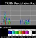
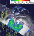
NASA's Tropical Rainfall Measuring Mission satellite (TRMM), a joint mission between NASA and the Japanese space agency JAXA, captured an image of Parma's rains already affecting the Philippines on October 2 at 00:43 UTC, 8:43 a.m. local Manila Time (8:43 p.m. EDT, Oct. 1). TRMM noticed that most of the rainfall around Parma's center is between 20 and 40 millimeters (.78 to 1.57 inches) per hour.
TRMM also noticed that some of Parma's "hot towers," towering thunderstorms are reaching as high as 14 kilometers (more than 8.5 miles high), indicating very powerful storms with heavy rainfall.
Warnings have already been posted in various areas of the Philippines. Public storm warning signal 1 is in force in Calayan Group of Islands, Babuyan Group of Islands, Ilocos Norte & Sur, Apayao, Abra, Kalinga, Mt. Province, Ifugao, Nueva Viscaya, Benguet, La Union, Pangasinan, Tarlac, Nueva Ecija, Zambales, Bataan, Pampanga, Bulacan, Laguna, Batangas, Cavite, Rizal, Rest of Quezon, Marinduque, Albay, Burias Islands, Sorsogon and Metro Manila.
Public storm warning signal 2 is in force in Cagayan, Isabela, Aurora, Quirino, Northern Quezon, Polilio Islands, Camarines Norte and Sur. Public storm warning signal 3 is in force in Catanduanes.
On October 2 at 15:00 UTC (11 p.m. local Asia/Manila Time, 11 a.m. EDT), Typhoon Parma had maximum sustained winds near 115 knots (132 mph) with higher gusts. That makes Parma a Category 4 Typhoon on the Saffir-Simpson Scale. Parma's center is located about 230 nautical miles east-northeast of Manila, the Philippines, near 16.2 North and 124.3 East.
At 11 a.m. EDT this morning, October 2, Manila is already experiencing rain and gusty winds, which will be tropical storm force later today. Typhoon Parma is a huge storm, and tropical storm-force winds extend outward from the center to as far as 210 miles. Hurricane/Typhoon-force winds extend up to 80 miles from Parma's center. Those winds are generating huge and dangerous ocean waves, as high as 32 feet high.
Parma is moving northwest at 8 mph and will continue in that direction, heading toward northeastern Luzon.
The National Hurricane Center's definition for a Category 4 Hurricane/Typhoon reads, "Sustained winds 131-155 mph (114-135 kt or 210-249 km/hr). Extremely dangerous winds causing devastating damage are expected. Some wall failures with some complete roof structure failures on houses will occur. All signs are blown down. Complete destruction of mobile homes (primarily pre-1994 construction). Extensive damage to doors and windows is likely. Numerous windows in high rise buildings will be dislodged and become airborne. Windborne debris will cause extensive damage and persons struck by the wind-blown debris will be injured or killed. Most trees will be snapped or uprooted. Fallen trees could cut off residential areas for days to weeks. Electricity will be unavailable for weeks after the hurricane passes."
After departing the Philippines, Parma will veer west, into the Luzon Strait and then into the northern South China Sea. Residents of eastern China and Taiwan need to monitor the progress of this storm.
Source: NASA/Goddard Space Flight Center
Articles on the same topic
- Warnings up for Philippines as Parma powers up to a super typhoonFri, 2 Oct 2009, 2:35:40 UTC
- NASA 3-D map shows flooding rains of Typhoon Ketsana in PhilippinesThu, 1 Oct 2009, 21:25:30 UTC
- NASA's infrared satellite images reveal Ketsana's deadly western Pacific marchWed, 30 Sep 2009, 22:10:43 UTC
Other sources
- NASA's TRMM sees huge Typhoon Parma bringing more rain to the Philippinesfrom Science BlogFri, 2 Oct 2009, 20:28:10 UTC
- NASA's TRMM sees huge Typhoon Parma bringing more rain to the Philippinesfrom PhysorgFri, 2 Oct 2009, 18:49:16 UTC
- NASA's TRMM sees huge Typhoon Parma bringing more rain to the Philippinesfrom Science BlogFri, 2 Oct 2009, 18:14:19 UTC
- Warnings up for Philippines as Parma powers up to a super typhoonfrom PhysorgFri, 2 Oct 2009, 2:35:09 UTC
- NASA 3-D map shows flooding rains of Typhoon Ketsana in Philippinesfrom PhysorgThu, 1 Oct 2009, 22:28:09 UTC
- NASA's infrared satellite images reveal Ketsana's deadly western Pacific marchfrom Science BlogThu, 1 Oct 2009, 1:28:19 UTC
- NASA's infrared satellite images reveal Ketsana's deadly western Pacific marchfrom Science BlogWed, 30 Sep 2009, 22:07:23 UTC
- NASA's infrared satellite images reveal Ketsana's deadly western Pacific marchfrom PhysorgWed, 30 Sep 2009, 22:07:10 UTC

