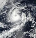
NASA follows Hurricane Orlene in the Eastern Pacific
The sixteenth tropical depression of the Eastern Pacific Ocean Hurricane Season formed on Saturday, Sept. 10 at 11 p.m. EDT and became a hurricane named Orlene early on Sept. 12. NASA-NOAA's Suomi NPP satellite captured an image of the strengthening storm. At 5:00 p.m. EDT (2100 UTC) on Sept. 11, 2016, NASA-NOAA's Suomi NPP satellite passed over Orlene when it was a strong tropical storm. The Visible Infrared Imaging Radiometer Suite (VIIRS) instrument aboard the satellite captured a visible image of the storm.
Using the Suomi NPP imagery and other satellite data, the National Hurricane Center noted "visible, infrared, and microwave satellite images indicate that Orlene continues to become more organized. The cyclone has well-defined curved bands, and a recent SSMIS image showed that it has a mid-level eye feature."
At 5 a.m. EDT (2 a.m. PDT/0900 UTC), the center of Hurricane Orlene was located near 17.1 degrees north latitude and 119.1 degrees west longitude.
The National Hurricane Center (NHC) said that Orlene is moving toward the northwest near 9 mph (15 kph). A turn toward the north-northwest and then north with a significant decrease in forward speed is expected during the next couple of days. Maximum sustained winds have increased to near 80 mph (130 kph) with higher gusts. Additional strengthening is forecast during the next day or so.
For additional updates on Orlene, visit the NHC website: http://www.nhc.noaa.gov.
Source: NASA/Goddard Space Flight Center
Articles on the same topic
- NASA sees formation of Central Atlantic Tropical Storm IanTue, 13 Sep 2016, 19:32:56 UTC
- NASA-NOAA's Suomi NPP finds powerful storms in Tropical Storm MalakasTue, 13 Sep 2016, 18:03:18 UTC
- NASA sees Tropical Depression Rai over Thailand, Vietnam, LaosTue, 13 Sep 2016, 17:33:30 UTC
- NASA catches Tropical Depression 19W nearing Vietnam after formationMon, 12 Sep 2016, 19:53:50 UTC
- NASA catches the short life of Tropical Depression 17WMon, 12 Sep 2016, 19:53:36 UTC
- NASA sees Tropical Storm 18W moving into Philippine seaMon, 12 Sep 2016, 19:53:11 UTC
- Tropical Depression 16W slowly intensifying and heading away from GuamMon, 12 Sep 2016, 19:53:00 UTC
Other sources
- NASA sees formation of Central Atlantic Tropical Storm Ianfrom PhysorgTue, 13 Sep 2016, 19:41:27 UTC
- Suomi NPP finds powerful storms in Tropical Storm Malakasfrom PhysorgTue, 13 Sep 2016, 18:12:29 UTC
- NASA sees Tropical Depression Rai over Thailand, Vietnam, Laosfrom PhysorgTue, 13 Sep 2016, 17:41:28 UTC
- NASA catches the short life of Tropical Depression 17Wfrom PhysorgMon, 12 Sep 2016, 20:51:32 UTC
- NASA sees Tropical Storm 18W moving into Philippine seafrom PhysorgMon, 12 Sep 2016, 20:51:31 UTC
- NASA catches Tropical Depression 19W nearing Vietnam after formationfrom PhysorgMon, 12 Sep 2016, 19:51:38 UTC
- NASA follows Hurricane Orlene in the Eastern Pacificfrom PhysorgMon, 12 Sep 2016, 17:21:33 UTC
- Tropical Depression 16W slowly intensifying and heading away from Guamfrom PhysorgFri, 9 Sep 2016, 19:51:27 UTC
