NASA data reveals tropical cyclone forming near Madagascar
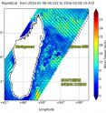
The Global Precipitation Measurement or GPM core satellite and NASA's RapidScat instrument aboard the International Space Station have provided forecasters with data that shows System 96S, a tropical low pressure area in the Southern Indian Ocean, is consolidating and developing into a depression. On Feb. 8, 2016 at 4 a.m. EDT RapidScat saw System 96S' winds were near 21 meters per second (46.9 mph/75.6 kph) on the storm's southeastern side. The RapidScat instrument flies aboard the International Space Station and measures surface winds over the ocean.
RapidScat is an important tool for meteorologists, because maximum sustained winds are not always equally distributed in a storm. RapidScat shows forecasters the location of the strongest winds in different quadrants of a storm, indicating locations facing greatest impacts.
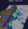
The GPM core observatory satellite flew over System 96S, located between Madagascar and Reunion, on Feb. 8, 2016 at 2137 UTC (4:37 p.m. EST). Rainfall derived from GPM's Microwave Imager (GMI) and Dual-frequency Precipitation Radar (DPR) data revealed that powerful convective storms near Madagascar's eastern coast were found to be dropping rain at a rate of over 94 mm (3.7 inches) per hour.
3-D measurements were made of convective storm tops with GPM's radar (DPR Ku band). A few of these tall thunderstorms were found to reach heights above 15 km (9.9 miles). Tall convective thunderstorms like this near the center of a tropical cyclone can signal intensification.
The Global Precipitation Measurement or GPM core observatory satellite is co-managed by both NASA and the Japan Aerospace Exploration Agency.
On Feb. 9, 2016 at 0200 UTC (Feb. 8, 2016 at 9 p.m. EST), System 96S was centered near 18.8 degrees south latitude and 51.3 degrees east longitude, approximately 280 nautical miles (322.2 miles/ 518.6 km) west-northwest of La Reunion island. La Reunion is located about 586 miles (944 km) east of Madagascar.
Recent animated infrared satellite imagery dhows deep convection (rising air that helps develop storms) and developing thunderstorms persisting over the western portion of the storm.
Forecasters at the Joint Typhoon Warning Center (JTWC) said that global computer models predict continued development of this disturbance over the next 24 hours. Low vertical wind shear will assist in the evolution of the tropical low as it was moves slowly toward the southwest. Maximum sustained surface winds are estimated between 27 to 32 knots (31 to 36.8 mph/50 to 59.2 kph). Minimum sea level pressure is estimated to be near 1002 millibars.
JTWC indicates that tropical cyclone development is likely in this area within 24 hours.
Source: NASA/Goddard Space Flight Center
Articles on the same topic
- NASA sees Tropical Cyclone Winston formThu, 11 Feb 2016, 20:28:56 UTC
- NASA's 2 eyes on Tropical Cyclone DayaThu, 11 Feb 2016, 19:16:27 UTC
- NASA's RapidScat spots newborn Tropical Cyclone TatianaThu, 11 Feb 2016, 19:16:16 UTC
- NASA sees Tropical Storm 10S formThu, 11 Feb 2016, 19:16:07 UTC
- NASA sees development of Tropical Storm 11P in Southwestern PacificThu, 11 Feb 2016, 19:16:00 UTC
- Intensifying Atlantic storm examined by NASA's GPMMon, 8 Feb 2016, 22:09:19 UTC
- NASA's GPM satellite examines violent thunderstormsMon, 8 Feb 2016, 22:09:01 UTC
- NASA measures 10 days of US extreme precipitation from spaceMon, 8 Feb 2016, 22:08:40 UTC
Other sources
- NASA sees Tropical Cyclone Winston formfrom PhysorgThu, 11 Feb 2016, 23:40:25 UTC
- NASA's RapidScat spots newborn Tropical Cyclone Tatianafrom PhysorgThu, 11 Feb 2016, 19:10:49 UTC
- NASA's two eyes on Tropical Cyclone Dayafrom PhysorgThu, 11 Feb 2016, 19:10:47 UTC
- NASA sees Tropical Storm 10S formfrom PhysorgWed, 10 Feb 2016, 18:27:58 UTC
- NASA sees development of Tropical Storm 11P in Southwestern Pacificfrom PhysorgWed, 10 Feb 2016, 18:23:06 UTC
- NASA data reveals tropical cyclone forming near Madagascarfrom PhysorgTue, 9 Feb 2016, 18:59:52 UTC
- Intensifying Atlantic storm examined by NASA's GPMfrom PhysorgMon, 8 Feb 2016, 22:01:07 UTC
- GPM satellite examines violent thunderstormsfrom PhysorgSat, 6 Feb 2016, 1:13:41 UTC
- NASA measures ten days of US extreme precipitation from spacefrom PhysorgThu, 4 Feb 2016, 22:28:40 UTC

