NASA sees wide-eyed Tropical Cyclone Victor
Related images
(click to enlarge)
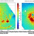
NASA satellites and instruments have been monitoring Tropical Cyclone Victor, a hurricane in the South Pacific Ocean with a large eye. NASA's Aqua satellite, NASA-NOAA's Suomi NPP satellite and the RapidScat instrument aboard the International Space Station have all gathered data on the storm. The RapidScat instrument that flies aboard the International Space Station measured Tropical Cyclone Victor's wind speed at the surface. Surface wind speed is always lower than speeds at higher altitude.
RapidScat is an important tool for meteorologists, because maximum sustained winds are not always equally distributed in a hurricane or tropical storm. RapidScat sustained wind data shows forecasters the location of the strongest winds in different quadrants of a storm. On Jan. 16 RapidScat measured Victor's strongest winds near 30 meters per second (67 mph/108 kph) in all quadrants except the western side, which was slightly weaker. By Jan. 18, the storm was hurricane-strength and those strongest winds had increased to 36 meters per second (80.5 mph/129.6 kph) and shifted to the western, southern and eastern quadrants of the storm.
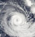
On Jan. 18 at 00:45 UTC (Jan. 17 at 9:45 p.m. EST) the MODIS or Moderate Resolution Imaging Spectroradiometer instrument aboard NASA's Aqua satellite provided a visible light image of Tropical Cyclone Victor. At that time, Victor's eye was almost due east of the Cook Islands.
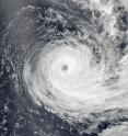
By Jan. 19 at 01:00 UTC when NASA-NOAA's Suomi NPP satellite passed over Victor, the eye had moved southeast of the Cook Islands. The VIIRS instrument aboard Suomi NPP captured another visible image of the wide-eyed hurricane and observed that the eye was more open than it was during the time the Aqua satellite passed overhead. The eye was about 35 nautical miles (40 miles/64 km) wide. The Suomi image showed strong bands of thunderstorms wrapping into that ragged eye.
Later in the day at 0900 UTC (4 a.m. EST), Victor's maximum sustained winds were near 80 knots (92 mph/ 148.2 kph). Victor was moving to the southwest at 6 knots (6.9 mph/11.1 kph). It was centered near 20.9 degrees south latitude and 167.3 degrees west longitude, about 410 nautical miles west of Rarotonga, Cook Islands.
Forecasters at the Joint Typhoon Warning Center expect Victor to continue moving in a west-southwesterly direction while slowly weakening over the next couple of days. By. Jan. 22, Victor is forecast to turn to the south and will have weakened to tropical storm status and transition into an extra-tropical storm.
Source: NASA/Goddard Space Flight Center
Articles on the same topic
- NASA sees Tropical Cyclone Victor weakening under wind shearFri, 22 Jan 2016, 21:44:47 UTC
- NASA measures rainfall in newborn Tropical Cyclone CorentinThu, 21 Jan 2016, 20:28:28 UTC
- NASA sees cloud top temperatures warming in Cyclone VictorThu, 21 Jan 2016, 20:28:13 UTC
- NASA measures winds in Tropical Cyclone VictorThu, 21 Jan 2016, 19:58:05 UTC
Other sources
- NASA sees Tropical Cyclone Victor weakening under wind shearfrom PhysorgFri, 22 Jan 2016, 23:44:01 UTC
- NASA sees cloud top temperatures warming in Cyclone Victorfrom PhysorgThu, 21 Jan 2016, 20:22:47 UTC
- NASA measures rainfall in newborn Tropical Cyclone Corentinfrom PhysorgThu, 21 Jan 2016, 19:52:31 UTC
- NASA measures winds in Tropical Cyclone Victorfrom PhysorgWed, 20 Jan 2016, 19:39:49 UTC
- NASA sees wide-eyed Tropical Cyclone Victorfrom PhysorgTue, 19 Jan 2016, 19:01:59 UTC


