NASA spots Kate speeding away from the Bahamas
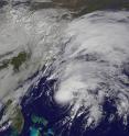
NOAA's Suomi NPP satellite and NOAA's GOES-East satellite both saw strong thunderstorms circling Tropical Storm Kate's center of circulation as the storm sped away from the Bahamas. A visible image Tropical Storm Kate near Bermuda was taken from NOAA's GOES-East satellite at 1430 UTC (9:30 a.m. EDT). The GOES-East image showed the concentration of thunderstorms around the center, which is covered by a small central dense overcast, and a fragmented band of thunderstorms northeast of the center.
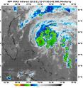
When NASA-NOAA's Suomi NPP satellite passed over Kate at 7:00 UTC (2 a.m. EST) the Visible Infrared Imaging Radiometer Suite or VIIRS instrument that flies aboard looked at the storm in infrared light. Cloud top temperatures of thunderstorms around the eyewall were between minus 70 and minus 80 degrees Celsius/minus 94 and minus 112 degrees Fahrenheit.
The higher the cloud tops, the colder they are as temperatures get colder with altitude in the troposphere. Storms with cloud top temperatures that cold have the capability of generating heavy rainfall.
At 10 a.m. EST (1500 UTC) on Nov. 10, the center of Tropical Storm Kate was located near latitude 30.2 North, longitude 74.7 West. That's about 350 miles (560 km) south of Cape Hatteras, North Carolina and 600 miles (970 km) west of Bermuda.
Kate was moving toward the northeast near 21 mph (33 kph), and the National Hurricane Center expects that general motion is expected to continue today with an increase in forward speed. On the forecast track, the center of Kate is expected to remain well offshore of the U.S. East Coast and pass north of Bermuda tonight and early Wednesday, November 11. Data from an Air Force Reserve Hurricane Hunter aircraft indicated that maximum sustained winds have increased to near 70 mph (110 kph) and Kate is forecast to become a hurricane at night on November 10. The latest minimum central pressure based on data from the aircraft is 999 millibars.
NHC forecasts Kate to turn northeastward and east-northeastward and accelerate more through Wednesday as it becomes embedded in the mid-latitude westerlies and speed into the North Atlantic. For forecast updates, visit the NHC website: http://www.nhc.noaa.gov.
Source: NASA/Goddard Space Flight Center
Articles on the same topic
- Former Tropical Cyclone Kate examined by GPM, RapidScat and GOES-EastFri, 13 Nov 2015, 18:04:10 UTC
- NASA spies Extra-Tropical Storm Kate racing through North AtlanticThu, 12 Nov 2015, 19:02:58 UTC
- NASA sees Tropical Storm Kate form, Bahamas under warningThu, 12 Nov 2015, 19:02:37 UTC
Other sources
- Former Tropical Cyclone Kate examined by GPM, RapidScat and GOES-Eastfrom PhysorgFri, 13 Nov 2015, 20:10:07 UTC
- NASA spies Extra-Tropical Storm Kate racing through North Atlanticfrom PhysorgThu, 12 Nov 2015, 19:00:09 UTC
- NASA spots Kate speeding away from the Bahamasfrom PhysorgTue, 10 Nov 2015, 17:30:37 UTC
- NASA sees Tropical Storm Kate form, Bahamas under warningfrom PhysorgMon, 9 Nov 2015, 20:50:27 UTC

