NASA satellites saw Tropical Depression Emily struggle over the weekend
Former Tropical Storm Emily made a brief comeback this weekend after degenerating over the mountains of Hispaniola late last week, and NASA's Aqua satellite captured an image of Emily just after her "rebirth." At 5 p.m. EDT on Saturday, August 6, Emily became a tropical depression for the second time in her life about 70 miles west-northwest of Great Abaco Island, near 26.9 North and 78.1 West. She was moving to the north at 8 mph and had a minimum central pressure of 1012 millibars. Maximum sustained winds were 30 mph.
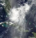
At 18:25 UTC 2:25 p.m. EDT, the Moderate Resolution Imaging Spectroradiometer (MODIS) instrument on NASA's Aqua satellite captured a visible image of Tropical Depression Emily, centered between southern Florida and the northern Bahamas. Emily's northeastern edge was over Grand Bahama Island at that time. Emily's northwestern edge was brushing southeastern Florida.
A close look at the visible imagery shows higher thunderstorms around the center of circulation that were casting shadows on the lower surrounding thunderstorms. Those higher thunderstorms around the center were an indication of strengthening and Emily's winds did pick up that night.
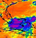
At the same time, another instrument on NASA's Aqua satellite took an infrared image of Emily's cloud top temperatures. The Atmospheric Infrared Sounder (AIRS) instrument saw several areas around Emily's center of circulation with highest, coldest, cloud tops, where thunderstorms were the strongest and the heaviest rain was falling. Those areas appeared southwest of the center.
Her winds peaked on Sunday, August 7 at 11 a.m. EDT when they reached 35 mph. At that time, she was near 30.1 North and 76.0 West, about 300 miles southeast of Charleston, South Carolina.
By 5 p.m. EDT on Sunday, August 7, just 24 hours after regaining her stature as a tropical depression, she was dissipating. Her winds were back down to 30 mph, and she was moving to the northeast near 17 mph. Maximum sustained winds were near 30 mph and pressure was 1011 millibars.
Monday, August 8 revealed that Emily was now a remnant elongated low pressure area centered near 32 North and 73 West. The remnants are being absorbed into a frontal boundary to the north.
Source: NASA/Goddard Space Flight Center
Articles on the same topic
- GOES-13 Satellite watches Emily fizzle, morph and hope for a comebackMon, 8 Aug 2011, 17:33:54 UTC
Other sources
- NASA satellites saw Tropical Depression Emily struggle over the weekendfrom PhysorgMon, 8 Aug 2011, 17:31:08 UTC
- GOES-13 Satellite watches Emily fizzle, morph and hope for a comebackfrom PhysorgSat, 6 Aug 2011, 6:30:31 UTC

