NASA measuring Tropical Storm Yasi's inland rainfall from space
Tropical Cyclone Yasi has continued moving through inland Queensland, Australia and has weakened to a tropical depression today. NASA and JAXA's TRMM satellite passed over Yasi as it continued to drop moderate to heavy rainfall. On February 3 at 0300 UTC (Feb. 2 at 10 p.m. EST/1 p.m. Australia local time) Tropical cyclone Yasi continued over land as a tropical storm. Yasi's maximum sustained winds were near 60 knots (69 mph/111 kmh). It was moving west-southwest near 20 knots/23 mph/37 kmh). It was located about 200 miles (321 km) southwest of Cairns, Australia near 19.3 South and 143.4 East.
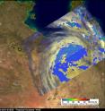
Just 39 minutes after the position of Yasi's center was determined, the Tropical Rainfall Measuring Mission (TRMM) satellite flew above the cyclone at 0339 UTC (Feb. 2 at 10:39 p.m. EST/1:39 p.m. Australia local time) collecting data on rainfall rates. Yasi had weakened to tropical storm strength but TRMM Microwave Imager (TMI) and Precipitation Radar (PR) data reveal that the storm was still dropping moderate to heavy rain over Australia in an area southeast of the Gulf of Carpentaria.
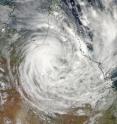
Just about an hour later, another NASA satellite passed over Yasi capturing the massive size of the strom in a visible image. The Moderate Resolution Imaging Spectroradiometer (MODIS) instrument that flies onboard NASA's Aqua satellite captured data on Yasi at 04:15 UTC (Feb. 2 at 11:15 p.m. EST/2:15 p.m. Australia local time. The center of Yasi had already moved inland and the eye of the storm had become obscured by clouds.
The Australia Bureau of Meteorology (ABoM) website has been updating residents of Yasi's movement and affects. To see the ABoM's radar, visit: http://www.bom.gov.au/products/national_radar_sat.loop.shtml.
At 9:30 a.m. EST (14:30 UTC) on Feb. 3 (or 12:30 a.m. Australia local time on Feb. 4) Yasi was approaching the border of the Northern Territory and had weakened into a tropical depression. The ABoM noted that isolated thunderstorms, heavy rains, flash flooding and damaging winds with gusts greater than 48 knots (55 mph/90 kmh) are possible in the western interior of Queensland. Updates from the ABoM can be found at: www.bom.gov.au.
Source: NASA/Goddard Space Flight Center
Articles on the same topic
- University of Leicester releases stunning satellite imagery of cyclone Yasi from spaceThu, 3 Feb 2011, 16:34:16 UTC
- NASA Aqua Satellite sees powerful Cyclone Yasi make landfall in Queensland, AustraliaWed, 2 Feb 2011, 22:03:02 UTC
- NASA satellites reveal heavy rains in dangerous Cyclone Yasi on its Australian approachTue, 1 Feb 2011, 20:34:36 UTC
- NASA sees large Tropical Cyclone Yasi headed toward Queensland, AustraliaMon, 31 Jan 2011, 19:20:49 UTC
Other sources
- NASA measuring Tropical Storm Yasi's inland rainfall from spacefrom PhysorgThu, 3 Feb 2011, 22:01:06 UTC
- NASA measuring Tropical Storm Yasi’s inland rainfall from spacefrom Science BlogThu, 3 Feb 2011, 22:00:37 UTC
- Scientists release stunning satellite imagery of cyclone Yasi from space (w/ Video)from PhysorgThu, 3 Feb 2011, 17:09:17 UTC
- University of Leicester releases stunning satellite imagery of cyclone Yasi from spacefrom Science BlogThu, 3 Feb 2011, 17:05:01 UTC
- NASA Aqua Satellite sees powerful Cyclone Yasi make landfall in Queensland, Australiafrom Science DailyThu, 3 Feb 2011, 3:30:41 UTC
- NASA Aqua Satellite sees powerful Cyclone Yasi make landfall in Queensland, Australiafrom PhysorgWed, 2 Feb 2011, 23:00:36 UTC
- NASA Aqua Satellite sees powerful Cyclone Yasi make landfall in Queensland, Australiafrom Science BlogWed, 2 Feb 2011, 23:00:28 UTC
- Cyclone Yasi expected to make landfall at midnight tonightfrom The Guardian - ScienceWed, 2 Feb 2011, 13:31:47 UTC
- Cyclone Yasi closes in on Australiafrom CBC: Technology & ScienceWed, 2 Feb 2011, 13:31:17 UTC
- Queenslanders bracing for cyclonefrom BBC News: Science & NatureWed, 2 Feb 2011, 10:32:27 UTC
- NASA satellite tracks menacing Australian cyclonefrom Science DailyWed, 2 Feb 2011, 6:30:49 UTC
- Monster cyclone Yasi eyes Australia in NASA imagefrom Science DailyWed, 2 Feb 2011, 6:30:31 UTC
- Monster Cyclone Yasi Eyes Australia in NASA Imagefrom NASA Jet Propulsion LaboratoryWed, 2 Feb 2011, 1:50:13 UTC
- NASA satellites reveal heavy rains in dangerous Cyclone Yasi on its Australian approachfrom Science BlogWed, 2 Feb 2011, 0:20:45 UTC
- NASA satellites reveal heavy rains in dangerous Cyclone Yasi on its Australian approachfrom PhysorgTue, 1 Feb 2011, 21:30:24 UTC
- NASA Satellite Tracks Menacing Australian Cyclonefrom NASA Jet Propulsion LaboratoryTue, 1 Feb 2011, 1:20:26 UTC
- NASA sees large Tropical Cyclone Yasi headed toward Queensland, Australiafrom Science BlogMon, 31 Jan 2011, 20:33:43 UTC
- NASA sees large tropical cyclone Yasi headed toward Queensland, Australiafrom PhysorgMon, 31 Jan 2011, 19:20:10 UTC

