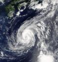
NASA sees Tropical Storm Lionrock sonsolidating
NASA's Terra satellite captured a visible image of Tropical Storm Lionrock that revealed the storm is consolidating and strengthening. Lionrock is moving through the Northwestern Pacific Ocean and away from Honshu, the big island of Japan. The Moderate Resolution Imaging Spectroradiometer or MODIS instrument aboard NASA's Terra satellite provided a visible look at Tropical Storm Lionrock on Aug. 22 at 9:40 p.m. EDT (Aug. 23 at 0140 UTC). The image showed powerful towering thunderstorms wrapping around the low-level center, with a thick band of thunderstorms extending from the north out to the east of the center. The Joint Typhoon Warning Center noted that animated multispectral satellite imagery showed a consolidating low-level circulation center with a formative eye and improved deep convective banding,
At 5 a.m. EDT (0900 UTC) on August 23, 2016 Tropical Storm Lionrock was centered near 27.2 degrees north latitude and 134.1 degrees east longitude, about 346 nautical miles east of Kadena Air Base, Okinawa, Japan. Lionrock has tracked south-southwestward at 5.7 mph (5 knots/9.2 kph). Maximum sustained winds were near 63 mph (55 knots/102 kph).
The Joint Typhoon Warning Center forecast calls for Tropical Storm Lionrock to move in a southwesterly direction and intensify into a typhoon. As it nears the island of Minami Diato Jima on Aug. 25 and 26 it is forecast to curve to the northeast.
Source: NASA/Goddard Space Flight Center
Articles on the same topic
- NASA sees examines new tropical storm in infrared lightThu, 25 Aug 2016, 18:04:09 UTC
- Tropical Depression 14W gets absorbed by system 92WThu, 25 Aug 2016, 16:04:25 UTC
- NASA sees a small tropical depression 14WWed, 24 Aug 2016, 17:06:54 UTC
- GPM sees Tropical Depression Kay fading into historyWed, 24 Aug 2016, 17:06:44 UTC
- NASA sees Lionrock strengthen into a typhoonWed, 24 Aug 2016, 16:36:10 UTC
- NASA's GPM observes Tropical Storm Gaston's developmentWed, 24 Aug 2016, 16:05:31 UTC
- NASA satellite spots new tropical depression in Northwestern Pacific OceanTue, 23 Aug 2016, 19:07:00 UTC
- NASA's Aqua Satellite sees Tropical Depression Kay sevoid of strengthTue, 23 Aug 2016, 17:04:40 UTC
- NASA witnesses Atlantic's Tropical Storm Gaston coming togetherTue, 23 Aug 2016, 16:04:42 UTC
- NASA Sees a Fading Fiona in AtlanticTue, 23 Aug 2016, 16:04:33 UTC
- NASA-NOAA's Suomi NPP Satellite sees two Tropical Cyclones near JapanMon, 22 Aug 2016, 17:34:20 UTC
- NASA sees Tropical Storm Fiona weakening from wind shearMon, 22 Aug 2016, 15:03:47 UTC
- NASA sees Tropical Storm Lionrock south of JapanFri, 19 Aug 2016, 18:04:13 UTC
- NASA spies Tropical Storm Mindulle's southern side strengthFri, 19 Aug 2016, 18:04:06 UTC
- NASA's Terra Satellite sees Tropical Storm Dianmu over VietnamFri, 19 Aug 2016, 18:03:54 UTC
- NASA spots strong convection in strengthening Tropical Storm KayFri, 19 Aug 2016, 15:05:16 UTC
- NASA sees wind shear affecting Tropical Storm FionaFri, 19 Aug 2016, 15:05:08 UTC
- NASA sees Tropical Storm 12W over the open Northwestern Pacific OceanThu, 18 Aug 2016, 19:07:13 UTC
- NASA sees Tropical Depression 10W form near GuamThu, 18 Aug 2016, 19:07:05 UTC
- NASA sees formation of Atlantic Ocean's Tropical Storm FionaThu, 18 Aug 2016, 17:03:51 UTC
- NASA sees Tropical Storm Chanthu moving over northern JapanWed, 17 Aug 2016, 17:06:02 UTC
- NASA sees sixth tropical cyclone form in AtlanticWed, 17 Aug 2016, 17:05:52 UTC
- NASA sees wind shear affecting Tropical Storm ChanthuWed, 17 Aug 2016, 17:05:44 UTC
- NASA sees Tropical Storm Chanthu east of JapanWed, 17 Aug 2016, 17:05:34 UTC
Other sources
- NASA sees examines new tropical storm in infrared lightfrom PhysorgThu, 25 Aug 2016, 18:01:39 UTC
- Tropical Depression 14W gets absorbed by system 92Wfrom PhysorgThu, 25 Aug 2016, 16:32:19 UTC
- NASA sees a small tropical depression 14Wfrom PhysorgWed, 24 Aug 2016, 20:01:51 UTC
- GPM sees Tropical Depression Kay fading into historyfrom PhysorgWed, 24 Aug 2016, 20:01:50 UTC
- NASA's GPM observes Tropical Storm Gaston's developmentfrom PhysorgWed, 24 Aug 2016, 19:02:06 UTC
- NASA satellite spots new tropical depression in Northwestern Pacific Oceanfrom PhysorgTue, 23 Aug 2016, 19:03:04 UTC
- NASA's Aqua Satellite sees Tropical Depression Kay sevoid of strengthfrom PhysorgTue, 23 Aug 2016, 17:31:30 UTC
- NASA sees a fading Fiona in Atlanticfrom PhysorgTue, 23 Aug 2016, 16:31:45 UTC
- NASA witnesses Atlantic's Tropical Storm Gaston coming togetherfrom PhysorgTue, 23 Aug 2016, 16:31:41 UTC
- NASA sees Tropical Storm Lionrock sonsolidatingfrom PhysorgTue, 23 Aug 2016, 16:31:40 UTC
- NASA-NOAA's Suomi NPP Satellite sees two Tropical Cyclones near Japanfrom PhysorgMon, 22 Aug 2016, 17:31:15 UTC
- NASA sees Tropical Storm Fiona weakening from wind shearfrom PhysorgMon, 22 Aug 2016, 15:31:15 UTC
- Tropical Storm Fiona weakens to tropical depressionfrom UPIMon, 22 Aug 2016, 14:02:58 UTC
- Tropical Storm Fiona steady as two Atlantic disturbances formfrom UPISun, 21 Aug 2016, 18:01:18 UTC
- NASA sees Tropical Storm Lionrock south of Japanfrom PhysorgFri, 19 Aug 2016, 19:31:22 UTC
- NASA's terra satellite sees Tropical Storm Dianmu over Vietnamfrom PhysorgFri, 19 Aug 2016, 19:31:20 UTC
- NASA spies Tropical Storm Mindulle's southern side strengthfrom PhysorgFri, 19 Aug 2016, 19:31:19 UTC
- NASA sees wind shear affecting Tropical Storm Fionafrom PhysorgFri, 19 Aug 2016, 18:31:39 UTC
- NASA spots strong convection in strengthening Tropical Storm Kayfrom PhysorgFri, 19 Aug 2016, 15:01:28 UTC
- NASA sees Tropical Depression 10W form near Guamfrom PhysorgThu, 18 Aug 2016, 19:31:35 UTC
- NASA sees Tropical Storm 12W over the open Northwestern Pacific Oceanfrom PhysorgThu, 18 Aug 2016, 19:01:50 UTC
- NASA sees formation of Atlantic Ocean's Tropical Storm Fionafrom PhysorgThu, 18 Aug 2016, 17:31:25 UTC
- NASA sees sixth tropical cyclone form in Atlanticfrom PhysorgWed, 17 Aug 2016, 17:31:35 UTC
- NASA sees Tropical Storm Chanthu moving over northern Japanfrom PhysorgWed, 17 Aug 2016, 17:01:40 UTC
- NASA sees wind shear affecting Tropical Storm Chanthufrom PhysorgTue, 16 Aug 2016, 18:31:44 UTC
- NASA sees Tropical Storm Chanthu east of Japanfrom PhysorgMon, 15 Aug 2016, 20:01:54 UTC
