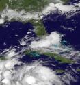
Satellite animation shows landfall of Hurricane Earl in Belize
A NASA satellite animation of imagery from NOAA's GOES-East satellite shows the movement and landfall of Hurricane Earl near Belize City, Belize. NOAA's GOES-East satellite has been providing visible and infrared data on Hurricane Earl since its development as a tropical depression on Aug. 2. At NASA's Goddard Space Flight Center in Greenbelt, Maryland, the NASA/NOAA GOES project combined the data into an animation that showed the movement and strengthening of Earl from Aug. 2 to Aug. 4 through the Caribbean Sea.
At 1 a.m. EDT on Thursday, Aug. 4, 2016 reports from an Air Force Reserve Hurricane Hunter aircraft indicated Earl's maximum sustained winds increased to near 80 mph (130 kph) making it a hurricane. At 2 a.m. EDT Hurricane Earl made landfall 5 miles southwest of Belize City, Belize.
By 11 a.m. EDT on Aug. 4, Earl was inland and already 115 miles (185 km) west of Belize City and had weakened to a tropical storm. The Government of Belize has discontinued all coastal warnings. There are no coastal watches or warnings in effect. Interests along the southern Bay of Campeche should monitor the progress of Earl.
The center of Tropical Storm Earl was located well inland near 17.2 degrees north latitude and 89.9 degrees west longitude. Earl was moving toward the west near 12 mph (19 kph), and the National Hurricane Center (NHC) said this general motion is expected to continue during the next couple of days. On the forecast track, NHC said Earl will continue to move across northern Guatemala and southeastern Mexico tonight and Friday. The estimated minimum central pressure is 990 millibars.
Maximum sustained winds have decreased to near 50 mph (85 kph) with higher gusts. Additional weakening is expected as the center moves over high terrain, and Earl is forecast to weaken to a tropical depression by tonight.
In the NHC discussion, Forecaster Lixion Avila wrote: "Earl is already well inland over northern Guatemala, and although visible satellite images still show a vigorous circulation, the convection is rapidly decreasing. There are no wind observations near the center, but the best estimate of the initial intensity is 45 knots. Since most of the circulation of Earl is forecast to move over the high terrain of Guatemala and southeastern Mexico, rapid weakening is anticipated. Earl is expected to degenerate into a tropical depression tonight and into a remnant low in a day or so."
For additional updates, visit the NHC website at: http://www.nhc.noaa.gov.
Source: NASA/Goddard Space Flight Center
Articles on the same topic
- NASA sees Tropical Storm Earl over MexicoFri, 5 Aug 2016, 15:37:49 UTC
- NASA's GPM sees towering thunderstorms in intensifying Tropical Storm EarlThu, 4 Aug 2016, 14:36:13 UTC
- Tropical Storm Earl forms in Caribbean SeaWed, 3 Aug 2016, 11:35:20 UTC
Other sources
- NASA's IMERG measures Hurricane Earl's deadly rainfall in Mexicofrom PhysorgTue, 9 Aug 2016, 19:51:25 UTC
- At least 39 dead in landslides as Tropical Storm Earl sweeps over Mexicofrom UPIMon, 8 Aug 2016, 6:31:15 UTC
- Tropical Storm Earl leaves six dead in Mexicofrom UPISun, 7 Aug 2016, 15:31:15 UTC
- NASA sees Tropical Storm Earl over Mexicofrom PhysorgFri, 5 Aug 2016, 15:31:35 UTC
- Flooding, mudslide warnings after Tropical Storm Earl passes Belize, Guatemala, Mexicofrom UPIFri, 5 Aug 2016, 12:31:14 UTC
- Satellite animation shows landfall of Hurricane Earl in Belizefrom PhysorgThu, 4 Aug 2016, 19:01:22 UTC
- GPM sees towering thunderstorms in intensifying Tropical Storm Earlfrom PhysorgThu, 4 Aug 2016, 15:01:17 UTC
- Hurricane Earl makes landfall in Belize; is expected to weakenfrom UPIThu, 4 Aug 2016, 11:31:23 UTC
- Hurricane warnings issued as Tropical Storm Earl heads toward Belize, Mexicofrom UPIWed, 3 Aug 2016, 11:31:09 UTC
- Tropical Storm Earl forms in the Caribbean after 6 die in Dominican Republicfrom UPITue, 2 Aug 2016, 20:01:44 UTC
- Tropical Storm Earl forms in Caribbean Seafrom PhysorgTue, 2 Aug 2016, 19:01:21 UTC
- Tropical Storm Earl Forms in the Caribbean after 6 die in Dominican Republicfrom UPITue, 2 Aug 2016, 18:31:21 UTC
