NASA gets 2 views of Tropical Depression 8 off the Carolina coast
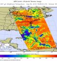
NASA got a look at Tropical Depression 8 in infrared and visible light as it started moving away from the coast of North Carolina. The Atmospheric Infrared Sounder or AIRS instrument that flies aboard NASA's Aqua satellite analyzed the depression when it was close to the coast of North Carolina. AIRS looked at Tropical Depression 8 (TD8) in infrared light on Aug. 30 at 2:05 p.m. EDT (1805 UTC) gathering temperature data of the system's clouds. Strong thunderstorms were seen around the center of circulation where cloud top temperatures exceeded minus 63 degrees Fahrenheit (minus 53 degrees Celsius). Storms with temperatures that cold are high in the troposphere and NASA research has shown they have the ability to generate heavy rain.
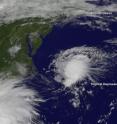
NOAA's GOES-East satellite captured a visible image of Tropical Depression 8 on Aug. 17 at 10:45 a.m. EDT (1445 UTC). The depression appeared as a circular area of clouds off the North Carolina coast. The National Hurricane Center discussion noted "The depression looks a little better organized this morning, with a large band on the eastern side of the circulation."
NOAA manages the GOES series of satellites and the NASA/NOAA GOES Project at NASA's Goddard Space Flight Center in Greenbelt, Maryland uses the satellite data to create images and animations.
At 11 a.m. EDT (1500 UTC), the center of Tropical Depression Eight was located near 35.5 degrees north latitude and 73.1 degrees west longitude. That's about 135 miles (220 km) east-southeast of Cape Hatteras, North Carolina.
The depression is moving toward the northeast near 15 mph (24 kph). This general motion with an increase in forward speed is forecast during the next day or so. The estimated minimum central pressure is 1010 millibars.
Maximum sustained winds are near 35 mph (55 kph) with higher gusts. Some strengthening is still possible and the depression could become a tropical storm later today.
There are no coastal watches or warnings in effect.
NHC forecaster Avila noted "The depression is moving slowly toward the northeast at 4 knots, and is already embedded within the southwesterly flow ahead of an amplifying mid-latitude trough (elongated area of low pressure). This pattern favors a continuation of the northeast track away from the U.S coast with a significant increase in forward speed."
Source: NASA/Goddard Space Flight Center
Articles on the same topic
- NASA's Terra satellite sees small burst in Tropical Depression MadelineFri, 2 Sep 2016, 18:06:19 UTC
- NASA satellite sees dissipation of Tropical Depression 8Thu, 1 Sep 2016, 15:24:37 UTC
- NASA's Terra satellite sees development of Depression 15WWed, 31 Aug 2016, 20:04:03 UTC
- Intensifying Tropical Depression 9 checked by NASAWed, 31 Aug 2016, 19:44:47 UTC
- Satellite sees large Tropical Depression 9 in the Gulf of MexicoTue, 30 Aug 2016, 17:15:13 UTC
- Satellites see Tropical Depression 8 off the North Carolina coastTue, 30 Aug 2016, 17:15:01 UTC
- NASA peers into Tropical Depression 9 in the Gulf of MexicoMon, 29 Aug 2016, 19:05:14 UTC
- Forming Atlantic Tropical Depression 8 seen by NASAMon, 29 Aug 2016, 19:05:02 UTC
Other sources
- NASA's Terra satellite sees small burst in Tropical Depression Madelinefrom PhysorgFri, 2 Sep 2016, 18:31:22 UTC
- NASA satellite sees dissipation of Tropical Depression 8from PhysorgThu, 1 Sep 2016, 15:01:32 UTC
- NASA's Terra satellite sees development of Depression 15Wfrom PhysorgWed, 31 Aug 2016, 22:31:28 UTC
- Intensifying Tropical Depression 9 checked by NASAfrom PhysorgWed, 31 Aug 2016, 20:02:10 UTC
- NASA gets 2 views of Tropical Depression 8 off the Carolina coastfrom PhysorgWed, 31 Aug 2016, 17:31:49 UTC
- Satellite sees large Tropical Depression 9 in the Gulf of Mexicofrom PhysorgTue, 30 Aug 2016, 18:41:30 UTC
- Satellites see Tropical Depression 8 off the North Carolina coastfrom PhysorgTue, 30 Aug 2016, 17:11:49 UTC
- Tropical storm warning issued for North Carolinafrom UPITue, 30 Aug 2016, 11:41:14 UTC
- NASA peers into Tropical Depression 9 in the Gulf of Mexicofrom PhysorgMon, 29 Aug 2016, 19:01:24 UTC
- Tropical depressions target Florida, North Carolinafrom UPIMon, 29 Aug 2016, 18:01:16 UTC
- Forming Atlantic Tropical Depression 8 seen by NASAfrom PhysorgMon, 29 Aug 2016, 15:31:33 UTC
- Tropical disturbance to bring soaking rain to Floridafrom UPISat, 27 Aug 2016, 19:31:14 UTC
- GPM examines Tropical Storm Lesterfrom PhysorgFri, 26 Aug 2016, 21:41:29 UTC

