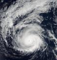
NASA satellite catches major Hurricane Madeline as Hawaii braces
NOAA's Suomi NPP and NOAA's GOES satellites showed major Hurricane Madeline nearing the Hawaiian Islands. An animation of satellite imagery showed the movement of Madeline and nearby Hurricane Lester over a two day period. At 7:25 p.m. EDT (23:25 UTC) on Aug. 29, the Visible Infrared Imaging Radiometer Suite (VIIRS) instrument aboard NASA-NOAA's Suomi NPP satellite captured a visible image of major Hurricane Madeline. The storm's eye extended up to 13 nautical miles wide in diameter and Madeline appeared very well organized.
By 11 p.m. EDT (5 p.m. HST) the storm was classified as a major hurricane when maximum sustained winds reached 115 mph (185 kph). Madeline had become a Category 3 hurricane on the Saffir-Simpson Wind Scale.
On Aug. 30, Madeline has sparked a hurricane watch for Hawaii County, Hawaii.
At NASA/NOAA's GOES project office at NASA's Goddard Space Flight Center in Greenbelt, Maryland, an animation of NOAA's GOES-East satellite imagery from Aug. 28 to Aug. 30 was created. The animation showed the movement of Hurricane Madeline intensify from a Category 2 to Category 4 hurricane. To the east of Madeline, Hurricane Lester was moving through the Eastern Pacific Ocean.
At 8 a.m. EDT (2 a.m. HST/1200 UTC), the center of Hurricane Madeline was located near 19.3 degrees north latitude and 147.7 degrees west longitude. That puts the eye of Madeline about 490 miles (790 km) east of Hilo, Hawaii and 680 miles (1,095 km) east of Honolulu, Hawaii.
NOAA's Central Pacific Hurricane Center (CPHC) said that Madeline is moving toward the west near 9 mph (15 kph) and this motion is expected to become west southwesterly late today through early Thursday. On the forecast track, the center of Madeline will pass dangerously close to the Big Island Wednesday and Wednesday night. The estimated minimum central pressure is 950 millibars.
Maximum sustained winds are near 130 mph (215 kph) with higher gusts. Madeline is a category 4 hurricane on the Saffir-Simpson Hurricane Wind Scale. Some weakening is forecast through early Thursday. Hurricane-force winds extend outward up to 30 miles (45 km) from the center and tropical-storm-force winds extend outward up to 125 miles (205 km).
Hurricane conditions are possible over Hawaii County on Wednesday, Aug. 31, and ocean swells are expected to reach the Hawaiian Islands over the next couple of days, possibly becoming damaging along some coastlines Wednesday and Thursday.
NOAA's CPHC said that heavy rains associated with Madeline may reach Hawaii County on Wednesday, and may impact other Hawaiian Islands later Wednesday into Friday. Madeline is expected to produce total rain accumulations of 5 to 10 inches, with isolated maximum amounts near 15 inches, especially over windward portions of the Big Island. This rainfall may lead to dangerous flash floods and mudslides.
Source: NASA/Goddard Space Flight Center
Articles on the same topic
- NASA sees Hurricane Lester approaching Hawaiian IslandsFri, 2 Sep 2016, 17:06:25 UTC
- NASA sees a weaker Tropical Storm Madeline passing south of Hawaii's Big IslandThu, 1 Sep 2016, 16:26:36 UTC
- NASA sees Lester move into central Pacific Ocean basinThu, 1 Sep 2016, 16:26:27 UTC
- Satellites show Hurricane Madeline weakening upon approach to HawaiiWed, 31 Aug 2016, 20:04:10 UTC
- NASA's GPM examines Category Four Hurricane LesterWed, 31 Aug 2016, 16:06:48 UTC
- NASA looks at Eastern Pacific's Category 3 Hurricane LesterTue, 30 Aug 2016, 17:15:25 UTC
Other sources
- Lester downgraded to tropical depression in Pacificfrom UPISun, 4 Sep 2016, 21:21:15 UTC
- NASA sees Hurricane Lester approaching Hawaiian Islandsfrom PhysorgFri, 2 Sep 2016, 18:31:24 UTC
- Hawaiian islands prepare for Hurricane Lesterfrom UPIFri, 2 Sep 2016, 10:31:25 UTC
- NASA sees Lester move into central Pacific Ocean basinfrom PhysorgThu, 1 Sep 2016, 17:32:01 UTC
- NASA sees a weaker Tropical Storm Madeline passing south of Hawaii's Big Islandfrom PhysorgThu, 1 Sep 2016, 17:31:54 UTC
- Hawaii avoids direct hit from Tropical Storm Madeline; Hurricane Lester loomsfrom UPIThu, 1 Sep 2016, 11:31:28 UTC
- Hawaii declares emergency as it prepares for first Hurricane hit since 1949from UPIThu, 1 Sep 2016, 1:01:18 UTC
- Satellites show Hurricane Madeline weakening upon approach to Hawaiifrom PhysorgWed, 31 Aug 2016, 22:31:23 UTC
- Cameras On The ISS Capture Gorgeous Time-Lapse Footage Of Three Hurricanesfrom PopSciWed, 31 Aug 2016, 19:31:13 UTC
- 3 for 1: Space Station Eyes Hurricanes Lester, Madeline and Gastonfrom Space.comWed, 31 Aug 2016, 18:41:22 UTC
- 3 for 1: Space Station Eyes Hurricanes Lester, Madeline and Gastonfrom Live ScienceWed, 31 Aug 2016, 18:41:21 UTC
- NASA's GPM examines Category Four Hurricane Lesterfrom PhysorgWed, 31 Aug 2016, 16:01:40 UTC
- Madeline weakens to Category 1 but still headed for Big Islandfrom UPIWed, 31 Aug 2016, 13:31:24 UTC
- Hurricane Madeline weakens to category 3, but still packing punch near Hawaiifrom UPIWed, 31 Aug 2016, 1:01:15 UTC
- Three Hurricanes Seen From Space Station On Same Day | Time-Lapse Videofrom Space.comTue, 30 Aug 2016, 21:11:20 UTC
- Three Hurricanes Seen From Space Station On Same Day | Time-Lapse Videofrom Live ScienceTue, 30 Aug 2016, 20:41:18 UTC
- NASA looks at Eastern Pacific's Category 3 Hurricane Lesterfrom PhysorgTue, 30 Aug 2016, 17:11:45 UTC
- NASA satellite catches major Hurricane Madeline as Hawaii bracesfrom PhysorgTue, 30 Aug 2016, 17:11:44 UTC
- Madeline strengthens into Category 4 hurricane, heads toward Hawaiifrom UPITue, 30 Aug 2016, 16:41:26 UTC
- Madeline strengthens into category 4 hurricane; heading toward Hawaiifrom UPITue, 30 Aug 2016, 15:41:20 UTC
- NASA spots Central Pacific's Madeline strengthening into a hurricanefrom PhysorgMon, 29 Aug 2016, 19:01:30 UTC
