NASA sees a tightly wrapped Tropical Cyclone Abela
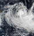
NASA satellite imagery shows that Tropical Cyclone Abela's center has become tightly wrapped. On July 16 the first Tropical Cyclone of the year formed in the Southern Indian Ocean. Tropical cyclone 01S, now known as Abela, developed about 320 nautical miles west-southwest of Diego Garcia.
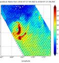
NASA's RapidScat instrument measured the surface winds around Tropical Cyclone Abela on July 17 and found the strongest winds stretching from northeast to southeast of the center of circulation (red) near 30 meters per second (67 mph/108 kph). Winds around the rest of the storm were around or less than 22 m/s (50 mph/80 kph).
RapidScat flies aboard the International Space Station and is helpful to forecasters because it shows where the strongest winds are in the storm (winds are not evenly distributed).
At 1500 UTC (11 a.m. EDT) on July 18, Tropical Cyclone Abela was located near 13.6 degrees south latitude and 59.8 degrees east longitude. That's about 440 nautical miles (506 miles/815 km) north-northeast of Port Louis, Mauritius. Abela has been moving to the west-southwest at 14 knots (16.1 mph/25.9 kph). Maximum sustained winds were near 50 knots (57 mph/92 kph).
On July 18 at 09:30 UTC (5:30 a.m. EDT), the Visible Infrared Imaging Radiometer Suite (VIIRS) instrument aboard the Suomi NPP satellite captured an image of Tropical Cyclone Abela east of Madagascar. The VIIRS image showed a tightly-wrapped low-level center with bands of thunderstorms spiraling into it.
Tropical Cyclone Abela is forecast to move west-southwest towards Madagascar and will begin weakening because of adverse atmospheric conditions and cooler waters.
Source: NASA/Goddard Space Flight Center
Articles on the same topic
- NASA looks at Tropical Cyclone Abela in 3-DWed, 20 Jul 2016, 17:29:59 UTC
- NASA sees two areas of strength in a weakening Tropical Cyclone AbelaWed, 20 Jul 2016, 17:29:48 UTC
Other sources
- NASA Looks at Tropical Cyclone Abela in 3-Dfrom PhysorgWed, 20 Jul 2016, 17:21:54 UTC
- NASA sees two areas of strength in a weakening Tropical Cyclone Abelafrom PhysorgTue, 19 Jul 2016, 16:31:14 UTC
- NASA sees a tightly wrapped Tropical Cyclone Abelafrom PhysorgMon, 18 Jul 2016, 17:31:33 UTC

