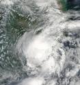
NASA's Aqua satellite sees Nepartak after landfall in China
The once powerful super typhoon Nepartak made landfall in eastern China as a minimal tropical storm after land falling in Taiwan as a typhoon. NASA's Aqua satellite captured an image of Nepartak over southeastern China after the storm's second landfall. he MODIS or Moderate Resolution Imaging Spectroradiometer instrument aboard NASA's Aqua satellite captured a visible image of Tropical Storm Nepartak on Saturday, July 9 at 05:25 UTC (1:25 a.m. EDT). Nepartak's center had already moved inland over southeastern China. Only the southeastern quadrant on the storm remained over the Taiwan Strait as the storm continued moving to the northwest.
At 0900 UTC (5 a.m. EDT) the Joint Typhoon Warning Center issued the final warning on Nepartak. It was a minimal tropical storm at the time with maximum sustained winds near 35 knots (40 mph/62 kph). It was near 25.1 north latitude and 118.4 longitude west. The center was located west of Quanzhou in the Fujian province of China. It was weakening quickly over land as it moved to the northwest at 9 knots (10.3 mph/16.6 kph).
By July 10, Nepartak had dissipated over China.
Source: NASA/Goddard Space Flight Center
Articles on the same topic
- NASA looks at Typhoon Nepartak over Taiwan in visible and infrared lightFri, 8 Jul 2016, 18:33:21 UTC
- NASA sees Super Typhoon Nepartak approaching TaiwanThu, 7 Jul 2016, 18:37:22 UTC
- Rapidly intensifying typhoon examined by NASA's GPM, RapidScatThu, 7 Jul 2016, 11:43:58 UTC
Other sources
- Aqua satellite sees Nepartak after landfall in Chinafrom PhysorgMon, 11 Jul 2016, 16:01:21 UTC
- Typhoon Nepartak kills six in China; eight missingfrom UPIMon, 11 Jul 2016, 11:31:14 UTC
- NASA looks at Typhoon Nepartak over Taiwan in visible and infrared lightfrom PhysorgFri, 8 Jul 2016, 20:11:15 UTC
- Super Typhoon Nepartak kills 2 in Taiwan, moves toward Chinafrom UPIFri, 8 Jul 2016, 12:11:05 UTC
- NASA sees Super Typhoon Nepartak approaching Taiwanfrom PhysorgThu, 7 Jul 2016, 23:01:15 UTC
- A Super Typhoon Is About to Wreak Havoc: What You Need to Knowfrom National GeographicThu, 7 Jul 2016, 21:11:07 UTC
- Super Typhoon Nepartak Spied from Space (Photos)from Space.comThu, 7 Jul 2016, 21:01:08 UTC
- Taiwan braces for Typhoon Nepartak, 200 mph winds expectedfrom UPIThu, 7 Jul 2016, 11:41:18 UTC
- Rapidly intensifying typhoon examined by NASA's GPM, RapidScatfrom PhysorgWed, 6 Jul 2016, 18:31:39 UTC
- NASA's Aqua satellite scans powerful Typhoon Nepartakfrom PhysorgTue, 5 Jul 2016, 19:31:31 UTC
