Rapidly intensifying typhoon examined by NASA's GPM, RapidScat
NASA looked at winds and rainfall within the first typhoon of the Northwestern Pacific 2016 hurricane season called Nepartak as it continued to intensify. On July 6, Nepartak strengthened into a super typhoon. NASA's RapidScat instrument measured winds around the system while NASA-JAXA's Global Precipitation Measurement or GPM core satellite analyzed rainfall rates with the typhoon.
Nepartak developed on July 3, 2016 south of Guam. Nepartak has moved to the west-northwest of Guam and has started to rapidly intensify. Warm water, low vertical wind shear and favorable outflow due an upper level trough are providing favorable environmental conditions for the typhoon.
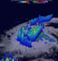
The GPM core observatory satellite flew above Nepartak on July 4, 2016 at 2151 UTC (5:51 p.m. EDT) when the tropical cyclone was still classified as a tropical storm. GPM's Microwave Imager (GMI) and Dual-Frequency Precipitation Radar (DPR) data showed that Nepartak was very close to forming an eye at that time. Very powerful storms near the center of Nepartak's circulation were found to be dropping rain at a rate of over 193 mm (7.6 inches) per hour.
GPM radar sliced through Nepartak and measured the 3-D vertical structure of very tall thunderstorm towers near the center of the intensifying tropical storm. These tall thunderstorms called "hot towers" were found to reach heights of 17.0 km (about 10.5 miles). These powerful storms near the center of a tropical cyclone are often seen prior to intensification. Energy released by rainfall into the center of a tropical cyclone provides the energy upon which tropical cyclones thrive.
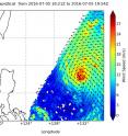
On July 5, NASA's RapidScat instrument measured Nepartak's wind speeds near or above 30 meters per second (67 mph/108 kph) around the center of the storm as the storm continued to strengthen. RapidScat measures winds on the surface of the ocean from its platform on the International Space Station.
Nepartak intensified over the next two days as it tracked under very warm sea surface temperatures, encountered very little wind shear and had good outflow of air at the top of the tropical cyclone.
Typhoon Warnings are in effect in Taiwan for Hualien and Taitung Counties. Hualien County is the largest county in Taiwan and is located on the mountainous eastern coast. Taitung county is south of Hualien County on the east coast. For updated warnings, visit Taiwan's Central Weather Bureau website at: http://www.cwb.gov.tw/eng/.
On July 7 at 1500 UTC (11 a.m. EDT) Super Typhoon Nepartak's maximum sustained winds had increased to 150 knots (172.6 mph/ 277.8 kph), making it a Category 5 hurricane on the Saffir-Simpson Scale. Nepartak was located approximately 509 nautical miles southeast of Taipei, Taiwan, near 19.8 north latitude and 127.7 east longitude. The storm was moving to the west-northwest at 18 knots (20.7 mph/33.3 kph). Napartak is generating wave heights to 48 feet (14.6 meters).
Because Nepartak entered the eastern edge of the Philippine Atmospheric Geophysical and Astronomical Services Administration or PAGASA's forecast coverage boundaries PAGASA has designated the storm as "Butchoy." PAGASA always aSpartassigns tropical cyclones local names to storms.
The Joint Typhoon Warning Center forecast expects Nepartak to move northwest and gradually weaken beginning July 7. The cyclone is forecast to approach Taiwan
Source: NASA/Goddard Space Flight Center
Articles on the same topic
- NASA's Aqua satellite sees Nepartak after landfall in ChinaMon, 11 Jul 2016, 15:04:57 UTC
- NASA looks at Typhoon Nepartak over Taiwan in visible and infrared lightFri, 8 Jul 2016, 18:33:21 UTC
- NASA sees Super Typhoon Nepartak approaching TaiwanThu, 7 Jul 2016, 18:37:22 UTC
Other sources
- Aqua satellite sees Nepartak after landfall in Chinafrom PhysorgMon, 11 Jul 2016, 16:01:21 UTC
- Typhoon Nepartak kills six in China; eight missingfrom UPIMon, 11 Jul 2016, 11:31:14 UTC
- NASA looks at Typhoon Nepartak over Taiwan in visible and infrared lightfrom PhysorgFri, 8 Jul 2016, 20:11:15 UTC
- Super Typhoon Nepartak kills 2 in Taiwan, moves toward Chinafrom UPIFri, 8 Jul 2016, 12:11:05 UTC
- NASA sees Super Typhoon Nepartak approaching Taiwanfrom PhysorgThu, 7 Jul 2016, 23:01:15 UTC
- A Super Typhoon Is About to Wreak Havoc: What You Need to Knowfrom National GeographicThu, 7 Jul 2016, 21:11:07 UTC
- Super Typhoon Nepartak Spied from Space (Photos)from Space.comThu, 7 Jul 2016, 21:01:08 UTC
- Taiwan braces for Typhoon Nepartak, 200 mph winds expectedfrom UPIThu, 7 Jul 2016, 11:41:18 UTC
- Rapidly intensifying typhoon examined by NASA's GPM, RapidScatfrom PhysorgWed, 6 Jul 2016, 18:31:39 UTC
- NASA's Aqua satellite scans powerful Typhoon Nepartakfrom PhysorgTue, 5 Jul 2016, 19:31:31 UTC

