NASA peers into major Hurricane Blas
Related images
(click to enlarge)
As NASA satellites gather data on the first major hurricane of the Eastern Pacific Ocean hurricane season, Blas continues to hold onto its Category 3 status on the Saffir Simpson Wind Scale. On July 6 at 2155 UTC (5:55 p.m. EDT) NASA-NOAA-DOD's Suomi NPP satellite captured a visible light image of Hurricane Blas in the eastern Pacific Ocean. The image showed that Blas maintained a large eye with bands of powerful thunderstorms wrapping into the low-level center of circulation from the east.
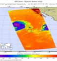
On July 6 at 2122 UTC (5:22 p.m. EDT), the AIRS or Atmospheric Infrared Sounder instrument aboard NASA's Aqua satellite captured an infrared view of Blas' cloud top temperatures, revealing powerful storms around the eye. By July 7, the National Hurricane Center (NHC) reported that the eye had become a little less distinct in the morning, and the surrounding ring of deep convection has warmed over the northwestern portion of the circulation. When cloud top temperatures warm that means they are not extending as high in the troposphere and indicate that the uplift of air is weakening.
At 11 a.m. EDT (1500 UTC) on July 7, the center of Hurricane Blas was located near latitude 16.2 North, longitude 127.1 West. That's about 1,210 miles (1,945 km) west-southwest of the southern tip of Baja California, Mexico. Blas was moving toward the west-northwest near 10 mph (17 kph), and the NHC said this motion is expected to continue through today. A turn toward the northwest is forecast on Friday.
Maximum sustained winds have decreased to near 120 mph (195 kph). NHC forecasts a weakening trend over the next two days and Blas is expected to weaken to a tropical storm by Friday night. For updated forecasts, visit the NHC website: http://www.nhc.noaa.gov.
Source: NASA/Goddard Space Flight Center
Articles on the same topic
- NASA sees Hurricane Blas closing its eyeFri, 8 Jul 2016, 16:04:11 UTC
- NASA sees Tropical Depression 4E formThu, 7 Jul 2016, 18:05:46 UTC
- NASA gets an eyeful of Hurricane BlasWed, 6 Jul 2016, 19:04:54 UTC
- NASA's Aqua satellite scans powerful Typhoon NepartakTue, 5 Jul 2016, 19:05:26 UTC
- NASA analyzes first hurricane of the Eastern Pacific seasonTue, 5 Jul 2016, 18:05:02 UTC
- Tropical Storm Agatha creates July 4th weekend fireworks in Eastern PacificTue, 5 Jul 2016, 18:04:51 UTC
Other sources
- NASA peers into major Hurricane Blasfrom PhysorgThu, 7 Jul 2016, 23:31:24 UTC
- NASA sees Tropical Depression 4E formfrom PhysorgThu, 7 Jul 2016, 23:01:13 UTC
- NASA gets an eyeful of Hurricane Blasfrom PhysorgWed, 6 Jul 2016, 19:32:03 UTC
- Tropical Storm Agatha creates July 4th weekend fireworks in Eastern Pacificfrom PhysorgTue, 5 Jul 2016, 18:01:42 UTC
- NASA analyzes first hurricane of the Eastern Pacific seasonfrom PhysorgTue, 5 Jul 2016, 18:01:41 UTC
- Tropical storms Agatha and Blas form in Eastern Pacific, no threatfrom UPISun, 3 Jul 2016, 17:41:05 UTC

